
1842 Tessan and Dépôt-Général de la Marine Map of the Galapagos Islands

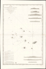
Carte d'une Partie de L'Archipel des Galapagos Levée et dressée en 1838 à bord de la Vénus...
Second earliest, and earliest obtainable scientific map of the Galapagos.
- Digital Map Information
- Suitable for large format printing
- File Size: 2032.23 MB
- File Type: ZIP / TIFF
- ICC color profile embedded
- Delivered instantly via download link
Second earliest, and earliest obtainable scientific map of the Galapagos.
An extraordinary discovery, this is Urbain Dortet de Tessan's 1842 nautical map of the Galapagos Islands, considered the second scientific map of the Galapagos. The map is the result of survey work performed in July of 1836 on the westward circumnavigation of the Vénus under Admiral Abel Aubert Dupetit-Thouars. The Vénus's visit to the Galapagos followed Darwin by just one year, and thus Beagle hydrographer Robert Fitzroy's contemporaneous mapping of the archipelago. This chart, published in 1842, and Fitzroy's chart, published in 1841, constitute the first comprehensive nautical overview of the islands and are comparable in both rarity and significance.A Closer Look
The chart is the result of about 10 days of survey work from July 4 - 14, 1836. Its coverage embraces the 12 major islands comprising the bulk of the archipelago. The whole is overlaid on a ghost-map following the Fitzroy survey. The Fitzroy content was likely added by the engraver, as it is unlikely that Tessan, the map's compiler, had access to Fitzroy's hydrography, given that the Beagle did not return to Europe until October 1836.The eastern part of the archipelago is neatly mapped with fully detailed topography and elevations - this is where the Vénus first arrived and began their survey in earnest. The larger islands to the west, including Albemarle (Isabela), Narborough (Fernandina), James (Santiago), and Indéfatigable (Santa Cruz), are more tenuously mapped from shipboard observations, some of which are distant.
Here, intriguingly, this map illustrates where Dupetit-Thouars's observations and ship hydrographer Jules Marie Enouts' calculations differ from those of Fitzroy. The Vénus observations, based on highpoints visible at sea, are in general about 1-2° further north.
The map includes 8 finely-engraved profile views of the islands of Culpepper, Wenman, Abingdon, Bindloe, Tower (Hawk), Chatham, Charles (Floriana), and Hood.
Circumnavigaton fo the Vénus
The Vénus expedition launched at the peak of the July Monarchy (1830 - 1848) under 'Citizen King' King Louis-Philippe I. After decades of upheaval following the French Revolution (1789 - 1799) and Napoleonic Wars (1803 - 1815), Louis-Philippe's government followed a pragmatic path in European relations, intent on stabilizing France and avoiding war. In contrast to the regime's diplomatically cautious approach to Europe, overseas it pursued a more aggressive campaign, intent on re-establishing French colonial power. The Vénus Expedition, under Admiral Abel Aubert Dupetit-Thouars, was part of this effort. Although steeped in enlightenment values, the mission also had a military purpose - to establish French political, colonial, and cultural influence throughout the Pacific, and in doing so challenge British regional hegemony.The Vénus Expedition (1836 - 1839) was launched to promote scientific discovery, naval prestige, and diplomatic presence - not necessarily in that order. Departing from Brest in December 1836, the westward circumnavigation reflected France's resurgence as a maritime power. It visited South America, the Galápagos, the Marquesas, Tahiti, New Zealand, the Indian Ocean, and Asia before returning to France in 1839. Its objectives were threefold: to chart and map poorly known coasts, to establish and strengthen commercial relations with Pacific and Asian ports, and to demonstrate French naval capability in regions dominated by Britain. The expedition's crew conducted hydrographic, astronomical, ethnographic, and natural history research, producing detailed maps (including of the Galápagos), specimen collections for the Muséum d'Histoire Naturelle, and extensive illustrated reports published as Voyage autour du monde sur la frégate La Vénus. Beyond its scientific achievements, the voyage marked the beginning of France's sustained Pacific involvement, laying the groundwork for potential territorial expansion in Polynesia, Southeast Asia, and the Philippines.
Publication History and Census
This map was produced by surveys conducted in July 1836 by the crew of the Vénus, specifically by the expedition's leader, Abel Aubert Dupetit-Thouars, hydrographer Jules Marie Enouts, and meteorologist Urbain Dortet de Tessan. When the expedition returned to France in 1839, Tessan took on the work of compiling the hydrographic and survey data into comprehensive, publishable charts. The current chart was engraved by Charles-Étienne Collin, with letter-engraving by Jacques Marie Hacq. It was published by the Dépôt Général de la Marine.Surviving examples are extremely scarce. OCLC notes just 2: British Library and PARIS-BSG Bibliothèque Nordique. In rarity, it is comparable to the Robert Fitzroy chart, itself known only at the British Library and the National Maritime Museum, Greenwich, with no history on the private market.
Cartographers
Urbain Dortet de L'Espigarié de Tessan (August 25, 1804 - September 30, 1879) was a French physicist and Hydrographer Engineer active in Paris during the early to middle part of the 19th century. Tessan was considered among the most scientific of cartographers active at the time, and his work is notable for its meticulousness and precision. Tessan was born in Vigan, the scion of an old Languedoc family. He graduated from the École Polytechnique in 1825. On graduation, he was placed in the command of Beautemps-Beaupré (1824), under whom he participated in the Gironde estuary campaigns (surveying shifting sandbanks) and Bayonne (1825 - 26), before conducting seabed surveys at Saint-Malo and Saint-Brieuc. He was then reassigned to Lieutenant Commander A. Bérard of the brig Le Loiret; with whom he mapped the Algerian coast, devising in the process a new technique for offshore surveying (1831 - 33). From 1836 to 1839, he participated as expedition meteorlogist on the Abel Aubert Dupetit-Thouars (1793 - 1864) expedition, a scientific-naval westward circumnavigation of the globe on the frigate Vénus. After the circumnavigation, he worked mostly in and around France, retiring in 1852 as a first-class engineer. In 1861, he was voted a full member of l'Académie des Sciences. Tessan published several important works on physics, hydrography, astronomy, and more. Some of his more significant research presaged the invention of sonar over one hundred years later. Further Details...
Dépôt des Cartes et Plans de la Marine (fl. 1720 - present), often called the Dépôt Général de la Marine, was a French hydrographic mapping organization founded in 1720 under Charles-Hercule of Albert de Luynes (1674 - 1734). Much like the U.S. Coast Survey, the British Admiralty, and the Spanish Deposito Hydrografico, the Dépôt was initiated as a storehouse and distribution center of existing nautical and marine charts. Eventually the Dépôt initiated its own mapping activities in an attempt to improve and expand upon existing material. Some of the more prominent cartographers and hydrographers associated with the of Dépôt Générale des Cartes were, Philippe Buache, Jacques-Nicholas Bellin, Giovanni Rizzi-Zannoni, Rigobert Bonne, and Jean Nicolas Buache. Further Details...
Charles-Étienne Collin (1770 - 1840) was a French engraver active in Paris during the late 18th and early 19th centuries. Collin was born in Paris to a long line of important French engravers dating back to Jean Collin. He was the son of Bernard Collin (1737 - 1791), son of Jean. Collin engraved for the seminal 1809 - 1822 Description de l'Egypte and extensively for the Dépôt de la Marine. He was contracted by his cousin by marriage, Phillipe Buache (1700 - 1773), for his exceptional engraving mastery to work for the Dépôt de la Marine from at least August 1793. He worked with his brother, Jean-Louis Collin (1775 - 1858), from 1800 to 1803. His son, also Charles-Étienne Collin or just Étienne Collin II (1790 - 1852), apprenticed under him and worked with him from 1821 to 1829. Under Charles-Étienne Collin (1770 - 1840) and then his son, the firm was located in Paris at N° 45, Rue de la Harpe - the last known work attributed to 'E. Collin' appeared in 1831. Distinguishing between the 'Collin' family of engravers on Dépôt de la Marine charts is difficult. The elder Étienne Collin (1770 - 1840) typically signed his work 'E. Collin' or later 'E. Collin père'. His son signs some of his work as 'E. Collin' and others as 'C.E. Collin fils.' There is some evidence of another generation of Collin engravers, also Charles-Étienne Collin, signing his work as 'C. E. Collin' between 1840 and 1875. Further Details...
Jacques-Marie Hacq (September 22, 1785 – 18??) was a French letter and line engraver, and historian, active in Paris during the middle part of the 19th century. Hacq was born in Paris and trained under J. P. Besançon, who he succeeded at the Dépôt de la Guerre in 1830. He engraved for the Dépôt de la Guerre as early as 1830 and for the Dépôt des Cartes et Plans de la Marine from, at least, 1840 to 1852. In addition to his work for the French Government, he also completed maps and engravings for Lesage, Lapie, Dufour, Duperrez, Gouvion St. Cyr, and Dumont d'Urville. His historical works include a history of the Napoleonic Wars and a history of Paris under the reign of Louis XIII. During most of his career in Paris he lived at 58 Rue de la Harpe. Further Details...
Condition
Very good. Partial centerfold repair on verso.
References
OCLC 497901782, 866848550.