This item has been sold, but you can get on the Waitlist to be notified if another example becomes available, or purchase a digital scan.
1795 Carey / Barker Map of Georgia
Georgia-carey-1795$500.00

Title
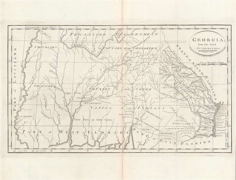
Georgia, from the latest authorities.
1795 (undated) 8.75 x 15.5 in (22.225 x 39.37 cm) 1 : 3000000
1795 (undated) 8.75 x 15.5 in (22.225 x 39.37 cm) 1 : 3000000
Description
This is a significant map of Georgia from Carey's General Atlas, considered the first atlas published in the new American Republic. It demonstrates that much of the modern state of Georgia was still occupied primarily by Native Americans and little understood by white settlers.
In the decades after independence, larger numbers of white settlers arrived in Georgia and pushed further inland, sparking conflicts with various Native American groups. In the early 1830s, President Andrew Jackson championed a policy of 'Indian removal,' a brutal program of ethnic cleansing.
The map includes West Florida, roughly concurrent with present-day southern Alabama The region changed hands between the French, Spanish, and British, while none maintained a significant presence there. It was primarily inhabited by Native American groups including the Natchez, Muscogee, and Choctaw. Spain had indirectly supported the American colonists in the Revolutionary War and taken control of West Florida as a result, but the northern boundary of both East and West Florida had not been fixed, precipitating a drawn-out diplomatic struggle with the new American Republic. Eventually, by the 1820s, through treaties, purchases, and declarations of independence by American settlers, both Floridas were incorporated into the United States, aided greatly by the rapid collapse of Spain's American empire, itself made possible by Napoleon's conquest of Spain in the Peninsular War.
A Closer Look
This map covers an area that was at that time filled with dense forests and swamps, and inhabited primarily by Native American peoples, who are indicated. Along with Savannah and Augusta, a string of towns and counties hug the coast and the Savannah and Tugaloo (here as Tongaloo) Rivers. Inland trade outposts, many with Native American names, and routes between them are signified with tents, tapering off further to the west.In the decades after independence, larger numbers of white settlers arrived in Georgia and pushed further inland, sparking conflicts with various Native American groups. In the early 1830s, President Andrew Jackson championed a policy of 'Indian removal,' a brutal program of ethnic cleansing.
The map includes West Florida, roughly concurrent with present-day southern Alabama The region changed hands between the French, Spanish, and British, while none maintained a significant presence there. It was primarily inhabited by Native American groups including the Natchez, Muscogee, and Choctaw. Spain had indirectly supported the American colonists in the Revolutionary War and taken control of West Florida as a result, but the northern boundary of both East and West Florida had not been fixed, precipitating a drawn-out diplomatic struggle with the new American Republic. Eventually, by the 1820s, through treaties, purchases, and declarations of independence by American settlers, both Floridas were incorporated into the United States, aided greatly by the rapid collapse of Spain's American empire, itself made possible by Napoleon's conquest of Spain in the Peninsular War.
Publication History and Census
This map is was engraved by William Barker (fl. 1785 - 1803) for the 1795 edition of Carey's General Atlas (sometimes subtitled American Edition of Guthrie's Geography improved). Multiple editions of which were printed between 1795 and 1818. The prevalence of the map is difficult to determine since it is not always cataloged with the year recorded, but both the individual map and the entire atlas are held by a handful of universities and research institutions in the United States and Europe.CartographerS
Matthew Carey (January 28, 1760 - September 16, 1839) was a Dublin born publisher who established himself in Philadelphia in the late 18th and early 19th century. A young man of socially progressive views, Carey's first known publication, produced when he was but 17 years old, was a pamphlet criticizing dueling. Another pamphlet, issued in the same year, attacked the Irish penal code. Shortly afterwards, in 1779, legal issues, possibly arising from his liberal political activism, forced Carey to flee to Paris. In Paris, Carey had the good fortune to befriend the visiting American diplomat and founding father, Benjamin Franklin (1706 - 1790). As an Irishman chafing under the rule of England, Carey sympathized with and admired the American revolutionary. The liberally minded pair struck up a lifelong friendship and Carey was hired to work at Franklin's press in Passy, France. A year later, Carey returned to Ireland and resumed his politically provocative publishing career with The Freemans's Journal and The Volunteer's Journal. It didn't take long for political pressure to once again force Carey from Ireland - this time to America (1784). Although largely without funds, Carey convinced Gilbert du Motier, Marquis de Lafayette (1757 - 1834), who he knew from Franklin's Paris circle, to lend him funds to establish a new publishing concern in Philadelphia. Despite this loan, Carey's firm remained under financed and opened on a shoestring budget. It was most likely his limited budget that led Carey to some of his most important publishing innovations. At the time cartographic publishing was dominated by large printing houses in London and Paris where most, if not all, of the work was completed in house. Without the finances to emulate this large publishing houses, Carey was forced to outsource much of his publishing work. This set the stage for subsequent American publishers who, in order to compete effectively with European firms, relied on an often bewildering network of alliances and collaborations. Carey was also a master of republishing many of his own maps in multiple different atlases and formats to maximize their profitability. His most important work is without a doubt the 1795 issue of the American Atlas the first atlas to be published in America. Carey died in 1839 but was succeeded by his son Henry Charles Carey (1793 - 1879) who, in partnership with his brother-in-law Isaac Lea (1792 - 1886), published numerous important maps and atlases under the Carey and Lea, Lea Brothers, and Lea and Blanchard imprints. More by this mapmaker...
William Barker (June 29, 1770 - April 19, 1805) was an engraver active in Philadelphia un the late 18th and early 19th centuries. Barker was born in Philadelphia, the son of Elihu Barker (17?? - 1792). Both father and son worked for the firm of Mathew Carey (1760 - 1839) and engraved maps for Carey's American Atlas, considered the first general atlas published in America. He appears in Philadelphia directories for 1795 - 1796 and 1800 - 1809. His business may have been carried on by a son of the same name, but it is unclear. Learn More...
William Guthrie (1708 - March 9, 1770) was a Scottish historian, journalist, and writer. Born in Brechin, he studied at Aberdeen University with the idea of becoming a parochial schoolmaster. Instead, in 1730, he elected to settle in London and try his hand at literature. He covered parliamentary debates f or the Gentleman's Magazine and soon earned a reputation for being a political writer. He published several scholarly works, including a History of England from the Invasion of Julius Caesar to 1688 in four volumes, and, most notably, his Geographical Historical, and Commercial Grammar. Learn More...
Source
Carey, M., Carey's General Atlas, (Philadelphia: Carey) 1796.
Condition
Very good. Wear toning, and verso stabilization on original centerfold.
References
Rumsey 2542.016, OCLC 852229935.