
1962 Jessup Propaganda Map of the World and Communist Expansion

Pattern of the Red Offensive.
The Red Scare.
$300.00
Choose a Collection:
This Item
Enquire
The Red Scare.
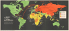
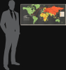
This 1962 Tony Sodaro map of the world strikingly illustrates the Cold War (1947 - 1991) dichotomy between the 'Allied Free Nations' and the 'Communist Alliance'. The map was published just months before the Cuban Missile Crisis. It captures rising global tensions between the West and the Soviet Union and China, and warns Western readers of the Communists' expansionist goals.A Closer Look
Centered on Europe, the map covers the wolrd on a Mercator Projeciton. Red, indicating communist territory dominates Asia - and thus the map. Large red arrows arc out of Moscow and Beijing, illustrating where the 'Communist Alliance' aimed to expand its influence. The Communist arrows spread worldwide, penetrating the Western Hemisphere in Cuba, Mexico, and Venezuela. Red and white stripes fill Cuba and Yugoslavia, marking these countries as having a 'Red Regime in Power'. Green (the color of money) indicates the global network of 'Allied Free Nations', with yellow defining 'Nonaligned Nations' (those that chose not to side with either the West or the Communists). Some of the red arrows point to these nonaligned countries. The remaining few countries, including the Republic of the Congo, Angola, Algeria, South Vietnam, and Laos, are orange, representing 'trouble and tension' - front lines in the Cold War.Historical Context
In March 1962, American involvement in Vietnam was expanding, the French lost the Algerian War, and, following the 1961 assassination of Congolese Prime Minister Patrice Lumumba, the CIA was still running covert operations in the Republic of the Congo. Both the Chinese and the Soviets were helping North Vietnam in its fight against South Vietnam (and the increasingly involved Americans), and China was still threatening Taiwan. Even with all these hotspots around the world, the world remembers 1962 for the Cuban Missile Crisis.The Cuban Missile Crisis
The Cuban Missile Crisis lasted for 13 days in October 1962, from the 16th through the 28th. This confrontation between the United States and the Soviet Union is considered the closest the two superpowers ever came to a full-scale nuclear war. The Crisis was ignited by Soviet ambitions to deploy ballistic missiles in Cuba, which were spurred by American deployments of Jupiter ballistic missiles in Italy and Turkey and the failed 1961 Bay of Pigs invasion. American U-2 spy planes confirmed Soviet preparations in Cuba, and American President John F. Kennedy declared that the United States would not tolerate offensive weapons in Cuba and ordered a naval blockade of the island. Kennedy and Soviet Premier Nikita Khrushchev came to an agreement after several days of negotiations. The Soviets agreed to remove all their offensive weapons in Cuba (which would be verified by the United Nations), and the U.S. publicly declared that it would never again attempt an invasion of the island. In secret, the U.S. agreed to dismantle the Jupiter missiles in Turkey, and it is speculated that the missiles in Italy were also included in the agreement. The negotiations also resulted in the creation of the Moscow-Washington hotline.Publication History and Census
This map was originally drawn by Tony Sodaro to illustrate Communism: The Nature of Your Enemy, a 77-page booklet published by LIFE Magazine and John K. Jessup in March 1962. The present example is an enlargement of the map that was published in that booklet. (A copy of the booklet has been digitized by the John F. Kennedy Presidential Library and Museum.) We note examples at: the University of Illinois at Urbana-Champaign and the University of California, Berkeley, and in Persuasive Maps: The PJ Mode Collection at Cornell University. This map occasionally appears on the private market.Condition
Average. Wear along original fold lines. Verso repairs to fold separations. Slight loss at fold intersections. Creasing.
References
Persuasive Maps: PJ Mode Collection 8548. OCLC 44524895.