
1775 Mannevillette Nautical Chart or Map of the Bay of Bengal, Indian Ocean


This item has been sold.
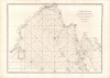
Carte Reduite du Golfe de Bengale, depuis L'Isle de Ceyland jusqu'au Golfe de Siam avec la partie Septentrionale du Detroit de Malac.
Among the earliest accurate charts of the Bay of Bengal.
- Digital Map Information
- Suitable for large format printing
- Full resolution TIFF file
- ICC color profile embedded
- Delivered instantly via download link
Among the earliest accurate charts of the Bay of Bengal.
An important 1775 chart of the Bay of Bengal issued for Jean-Baptiste Nicolas Denis d'Après de Mannevillette's La Neptune Oriental, the most influential work of hydrography dealing with Asia in its time.A Closer Look
As the subtitle indicates, coverage ranges from the southern tip of the Indian subcontinent to Cambodia and the Mekong Delta. Rivers, landmarks (such as pagodas), and coastal settlements are noted, including the French outposts of Pondicherry (Pondicheri), Yanam (Yanaon), and Karaikal (Careical), among others. Soundings are provided around Bengal and the Gulf of Thailand.Islands, shoals, hazards, and other features noted throughout, especially in difficult to navigate areas like the western coast of the Malay Peninsula and the Palk Strait between the Indian mainland and Ceylon (Sri Lanka). The placenames here are recognizable, although some are rather idiosyncratic. A prominent example is the term 'Rivière Japonoise' for a branch of the Mekong River, perhaps derived from the presence of Japanese traders in the area in the 17th century.
Publication History and Census
This chart appeared in the 1775 expanded edition of Mannevillette's La Neptune Oriental, first published in 1745. It is independently cataloged among the holdings of Northern Illinois University, Leiden University, the Sächsische Landesbibliothek of the Staats- und Universitätsbibliothek Dresden, the Bayerische Staatsbibliothek, and the National Library of Australia, while the Neptune Oriental is somewhat more widely distributed.Cartographer
Jean-Baptiste Nicolas Denis d'Après de Mannevillette (February 11, 1707 - March 1, 1780) was a French hydrographer, cartographer, and captain of the Compagnie des Indes, active principally at sea and at Lorient during the 18th century. Born at Le Havre into a seafaring family, he accompanied his father, the company captain Jean-Baptiste Claude d'Après de Blangy (1672 - 1744), aboard the Solide on a voyage to India and Bengal in 1719 - 1721. He subsequently studied geography and astronomy in Paris and entered the company's service in 1724. Voyages to West Africa, India, and China supplied observations and nautical documents for his systematic revision of charts of the eastern seas. An early French practitioner of navigation with Hadley's octant, he tested the instrument during a voyage to China beginning in 1736 and published instructions for its use in 1739. In 1742, he submitted his proposed sea atlas to the Compagnie des Indes, which supported its publication; in 1743, he became a corresponding member of the Académie royale des sciences. His principal work, Le Neptune Oriental, appeared in 1745 with 22 charts and accompanying sailing directions, establishing an influential reference for navigation between Africa and China. The atlas was well received, but shortly after publication, the French Admiralty destroyed most unsold copies, which it considered too dangerous to disseminate. He continued collecting surveys, comparing ships' journals, and correcting geographical positions throughout his career. In February 1762, he became keeper of the company's newly established repository of charts and journals at Lorient. His extensive correspondence with the Scottish hydrographer Alexander Dalrymple (1737 - 1808), begun in 1767, facilitated a reciprocal exchange of charts and observations that contributed to the greatly enlarged 1775 edition of Le Neptune Oriental. The two hydrographers never met. Mannevillette died at Lorient on March 1, 1780, aged 73; his papers were transferred to Paris, and further chart corrections appeared in a posthumous supplement in 1781. Further Details...
Source
Mannevillette, Jean-Baptiste d'Apres de, Le Neptune Oriental, (Paris) 1775.
Le Neptune Oriental was a large-scale maritime atlas first issued in 1745 by Jean-Baptiste Nicolas Denis d'Après de Mannevillette, a wealthy French sailor and hydrographer. From his first voyage as an adult in 1726, Mannevillette collected, revised, and created new nautical charts. These he published 20 years later in the first edition of Le Neptune Oriental, an important work issued for the Compagnie des Indes (French East India Company), for whom Mannevillette was a captain. The first edition of Le Neptune Oriental, containing 25 charts, was received and earned him accolades in both navigational and scientific circles. Nonetheless, according to Manonmani Filliozat, writing in the Indian Journal of the History of Science,
The French Admiralty, considering that the Neptune Oriental was too dangerous ... ordered the remaining copies to be destroyed. (#292, 1994, p. 341)This accounts somewhat for the extreme scarcity of the first edition and all of the maps contained therein. We also note a supportive comment in a 1763 catalog of maps and charts issued by the French chart and map dealer Roch-Joseph Julien (1745 - 1779). Mannevillette nonetheless continued to collect and revise charts for the next 30 years, often working with the important English cartographer Alexander Dalrymple (1737 - 1808). In 1775, he issued a greatly expanded and updated second edition of Le Neptune Oriental. The new edition featured an additional 41 charts, making a total of 63 charts. This edition also proved popular and was widely disseminated. As noted by multiple cartobibliographers, there are variations between examples, and no two seem to be identical, suggesting that many were compiled to order, often with additional maps that could be purchased but which were not in the standard collation. The second edition was published in Paris by Demonville and in Brest by Malassis. In 1781, one year after Mannevillette's, another work, Supplement au Neptune Oriental was issued, also by Demonville and Malassis.
Condition
Good. Edge wear and toning, including repaired wormholes in the bottom margin. Some centerfold wear. Light offsetting.
References
Rumsey 13102.045 (1810 edition). OCLC 7449425, 220498753, 220498753.