This item has been sold, but you can get on the Waitlist to be notified if another example becomes available, or purchase a digital scan.
1746 Anderson Map of Greenland and Iceland
Greenland-anderson-1746$1,000.00

Title
Nova Gronlandiae Islandiae et Freti Davis tabula : quam ex recentissimis, usque selectissimis peritiorum Navarchorum, item Dannicae missionis observationibus, relationibus atque diariis, peculiari studio.
1746 (dated) 14.5 x 11.5 in (36.83 x 29.21 cm) 1 : 7800000
1746 (dated) 14.5 x 11.5 in (36.83 x 29.21 cm) 1 : 7800000
Description
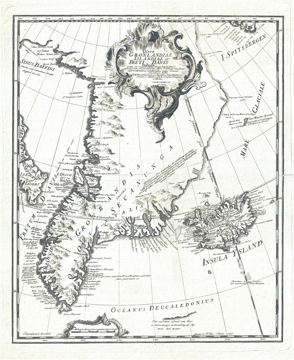
A scarce 1746 map of Greenland drawn to illustrated Johann Anderson's study on the North Atlantic, Nachrichten von Island, Grønland und der Strasse Davis. This is one of the earliest specific maps of Greenland. It covers from the Baffin Sea and Spitsbergen to the southern tip of Greenland, inclusive of Iceland. The map compiles all available knowledge of Greenland as of 1746 but remains quite vague beyond coastal settlements. Various early settlements are noted as are geographical oddities such as the Uunartoq Hot Springs (Onartook Thermae). The map also noted several early Danish settlements on the east littoral of Greenland, usually associated with churches, all of which were later abandoned. It also identifies the settlement of Norwegian cleric Hans Egede, on the western shore of the island. No doubt owing to Anderson's superior knowledge, there is no trace of the speculative passage through the island that would appear one year later in Emanuel Bowen's map. Iceland, appearing on the right hand side of the map, follows the model common on Dutch sea charts issued during the latter part of the 17th century.
Johann Anderson (1674-1743) was the son of a whaling ship owner from Hamburg, Germany. He became a lawyer, served in the Hamburg Senate, and was mayor of the city for many years. Anderson systematically gathered the available literature on Iceland, Greenland, and the adjacent seas, as well as gleaned information from sailors and merchants. This book, which he prepared mainly in the 1730s, was published in 1746, after his death. It includes descriptions of the land and peoples of Iceland and Greenland, and covers topics ranging from the herring fishery to the volumes of oil produced by different species of whales. Although he was wrong on some points, Anderson made scientific contributions in a number of areas. He developed a system for classifying species of whales and made estimates of commercial marine stocks that prefigured later work in fisheries biology. Appended to the work was a grammar and vocabulary of the Inuit language spoken on Greenland, and a selection of extracts from religious texts presented in German, Danish, and Inuit. Anderson’s book was valued throughout Europe, and was translated into and published in Danish (1748), Dutch (1750), and French (1750).
This map was drawn by Ernst Georg Sonnin , engraved by Jonas Carl Frederik Washer Haas, and printed by Georg Christian Grund for inclusions in Johann Anderson's posthumously published study on the North Atlantic, Nachrichten von Island, Grønland und der Strasse Davis.
CartographerS
Ernst Georg Sonnin (June 10, 1713 – July 8, 1794) was a German architect, engineer, cartographer, and architect active in Hamburg in the middle part of the 18th century. Sonnin attended the Friedrich School from 1727 to 1731 and then afterwards in Halle and Jenna. His focus was initially theology, but it quickly transitioned into mathematics. Relocating to Hamburg he tutored Latina and mathematics while founding a workshop for precision scientific instruments. As a master engineer he was contracted to do restoration work on the steeples of a number of important churches. He was a member of the first German Masonic Lodge and a founding member of the Hamburg Patriotischen Gesellschaft. Sonnin was a hobbyist astronomer and dedicated himself determining the exact geographical location of Hamburg. IN conjunction with his astronomical studies he contributed to several other little known maps in affiliation with other Hamburg scholars. More by this mapmaker...
Georg Christian Grund (July 11, 1695 – February 10, 1758) was a German printer, publisher, and engraver active in Hamburg in the middle part of the 18th century. He was the sone of the German typographer Hermann Heinrich Holle. Grund was the owner of the Hamburgischer Correspondent, which he renamed Staats- und gelehrte Zeitung des Hamburgischen unparteyischen Correspondenten (State and scholarly newspaper of Hamburg's nonpartisan correspondents). Until the outset of the French Revolution, this periodical was the only reliable source in Germany for foreign news. Little is known of his life and work but he appears to have engraved maps and images for Johann Anderson's 1746 Nachrichten von Island, Grønland und der Strasse Davis. Grund was a founding member of the Hamburg Patriotischen Gesellschaft. He was survived by his daughter Sophia Maria Grund. Learn More...
Jonas Carl Frederik Washer Haas (1720 - April 10, 1775) was a Nuremberg-born artist and engraver active in Copenhagen, Denmark, in the middle to late 18th century. Haas was born in Nuremberg in 1720. After several years in Hamburg, Haas relocated to Copenhagen along with several other of his fellow artists, including Johan Martin Preisler and Carl Marcus Tuscher. In 1755, Haas was appointed official engraver for the University of Copenhagen. In addition to numerous portraits, he engraved maps for Johan Jacob Bruun's Novus Atlas Daniæand, and vignettes of Frederik Ludvig Norden's Travels. In Hamburg, he had married Anna Rosine Fritsch, the daughter of a fellow engraver, with whome he had four children. Three of his sons, Georg, Meno, and Peter were also engravers. Haas is interred at St. Peter's church cemetery. Learn More...
Source
Anderson, J., Nachrichten von Island, Grønland und der Strasse Davis (Hamburg), 1747.
Condition
Very good. Minor verso reinforcement along centerfold. Platemark. Blank on verso.
References
OCLC 645249896.