
1969 Bullock Pictorial Historical Map of Ireland

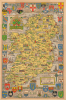
Historical Map of Ireland.
Playful pictorial map of Ireland.
Playful pictorial map of Ireland.
This is a delightful 1969 L. G. Bullock pictorial historical map of Ireland, published by the Edinburgh cartographic firm John Bartholomew and Sons. Combining decorative cartography, Irish history, genealogy, folklore, heraldry, architecture, and national identity, the map presents the island of Ireland as a vibrant tapestry of ancient clans, medieval castles, monastic foundations, historic battlefields, Viking incursions, regional traditions, and cultural landmarks.A Closer Look
The eye is drawn to lively sketches of Irish dancers, rural inhabitants, historical figures, and Viking invaders. Quotations, folk sayings, and explanatory inscriptions enliven the surrounding geography, providing cultural and historical context. Historic cathedrals, churches, and abbeys are marked with yellow crosses, while castles appear as small brown symbols; numerous additional monuments and historical sites are also identified. The locations of important battles and sieges are recorded throughout, including the sites of repeated conflicts. Names of ancient Irish clans and prominent families appear across their traditional territories, illustrating regional ancestry and genealogical associations. The map is framed by the heraldic arms of Irish cities and towns, including Belfast, Dublin, and Cork, together with the crests of the National University of Ireland and Queen's University Belfast.Publication History and Census
This map was designed and published in 1969 by L. G. Bullock and printed and published in Great Britain by John Bartholomew and Sons Ltd. of Edinburgh. It is part of a series of similar historical pictorial maps focused on the British Isles. The map is well represented in institutional collections.Cartographers
Leslie George Bullock (March 12, 1895 – November 29, 1971) was an English civil servant and cartographer active London during the middle part of the 20th century. Bullock was educated at the Alleyns School of Dulwich. After his schooling he took work with the Union Assurance Company with whom he trained as a fire surveyor. When World War I broke out he joined the Territorial Army. After the war he took work with the Port of London, where he remained until about 1932, when he was transferred to Scotland. Bullock enjoyed visiting London where he felt the truest way to experience the city was by riding the bus or talking a walk, where he would notice and appreciate little vignettes of life. This idea transferred to his cartographic designs, which are defined by small slice-of-life vignettes. All of his cartographic work was published by the firm of John Bartholomew. His most notable maps are his Children's Map of London, his historical maps of England, Scotland, Ireland, and Wales, his city plan of Glasgow, and his United Nations Map of the World. Further Details...
The Bartholomew Family (fl. c. 1810 - 1920) is clan of map publishers active in London through the 19th century. They represent one of the great names in British cartography. The cartographic story of the Bartholomew family begins with George Bartholomew (January, 8 1784 - October 23, 1871, active from 1797), an engraver in the employ of the Daniel Lizars firm of Edinburgh. George was the first of six generations in the Bartholomew map-making dynasty. It was his son, John Bartholomew Sr. (1805 - April 9, 1861) who ultimately founded John Bartholomew and Sons in 1828. The John Bartholomew firm produced thousands of maps and rose to become one of the largest and most prolific cartography firms in Scotland. John Sr. was succeeded by his son, also John Bartholomew Jr. (1831-93). John George Bartholomew (1860-1920), son of John Bartholomew (1831-93) took control of the firm at its height. John George was a charter member of the Royal Scottish Geographical Society and supported the creation of a National Institute of Geography - a good idea that never took off. John George is also reliably attributed to be the first to bring the term "Antarctica" into popular usage as a denominator for the Southern Continent. In recognition of his work, John George was awarded a warrant from the king and often used the title "Cartographer to the King" on his imprint. Among his friends and admirers he was referred to as the "Prince of Cartography". John (Ian) Bartholomew (1890 - 1962) continued the family business and oversaw publication of the Times Survey Atlas of the World in 1922 and the Mid Century Edition of the Time Atlas of the World from 1955 - 1960. John Christoper Bartholomew (1923 - 2008) continued the family business into a fifth generation and was fascinated by the natural sciences. He spearheaded the publication of many of the most detailed and popular maps of the last century. His brother Robert, a trained printer, became production director. Another brother, Peter, an accountant, started as a managing director and eventually became executive chairman. The John Bartholomew firm has been part of the HarperCollins family of publishers since 1989. The vast archive of maps and atlases produced by the Bartholomew family has since been transferred to the National Library of Scotland where it is currently in the cataloguing process. Further Details...
Condition
Good. Mounted on linen. Wear along original fold lines. Old cellophane tape in all four corners in margins. Pinholing in bottom center. Slight loss to top margin.
References
OCLC 27943037.