
1945 Army Map Service Map of Hong Kong, World War II, Proof Print

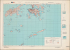

Hong Kong and Lema Islands. South Sheet. Second Edition - AMS 3.
Last Days of Japan's Occupation of Hong Kong
- Digital Map Information
- Suitable for large format printing
- Full resolution TIFF file
- ICC color profile embedded
- Delivered instantly via download link
Last Days of Japan's Occupation of Hong Kong
This is a 1945 Army Map Service map of Hong Kong, produced in the closing days of World War II. By this time, Hong Kong had suffered through nearly four years of starvation and oppression under Japanese occupation.A Closer Look
This map covers the most urbanized parts of Hong Kong, including the shores of Hong Kong Island and Kowloon on either side of Victoria Harbor, at the top. The rest of Hong Kong Island, along with Lantau Island, Lamma Island, and other outlying islands, including the titular Lema Islands, are displayed with contour lines indicating elevation. A legend at the bottom right explains the symbols and lines used for roads, railways, tracks of various qualities, footpaths, telegraph lines, churches, temples, lighthouses, maritime features, and terrain. This may have been a proof print for the A.M.S., given the line of colored squares in the top-left margin.The Occupation of Hong Kong
During World War II, Hong Kong was under Imperial Japanese occupation, which began on December 25, 1941, after the city surrendered following 18 days of fierce fighting. The Battle of Hong Kong was among the first battles of the Pacific War and coincided with the bombing of Pearl Harbor. Despite strong port-side defense capabilities, Hong Kong's garrison, composed of British, Indian, and Canadian units, along with Auxiliary Defence Units and the Hong Kong Volunteer Defence Corps, was quickly overwhelmed, leading to the surrender of the colony. The occupation lasted until the end of World War II (1939 - 1945), spanning 3 years and 8 months, marked by martial law and severe human rights abuses, including brutality, famine, malnourishment, and sickness in internment camps. (Macao, by contrast, remained neutral territory, though under increasing Japanese pressure and 'supervision' as the war went on.) The occupation of Hong Kong ended with the surrender of Japan following the dropping of the atomic bombs on Hiroshima and Nagasaki, and British troops returned to Hong Kong on August 30, 1945. However, this map was likely produced in the weeks before the dropping of the atomic bombs, when their existence was still a secret and Allied war planners would have had to contemplate a conventional operation to recapture Hong Kong.Publication History and Census
This map was issued by the Army Map Service in 1945, most likely in August, given the notation '8-45' in the bottom-right margin. It is based on an earlier map produced by the Geographical Section, General Staff of the British War Office, itself modifying an even earlier map by the British Admiralty. This is the second edition of both the War Office and A.M.S. map with this title, the first being issued in 1942 (OCLC 1602544846). There was a partner North Sheet, titled 'Hong Kong and New Territories,' with which the present map is generally cataloged. Although this map is well distributed in institutional collections, it is scarce to the market.Cartographers
The Army Map Service (AMS) (1941 - 1968) was the military cartographic agency of the U.S. Department of Defense and part of the U.S. Army Corps of Engineers. The AMS compiled, published, and distributed military topographical maps and other related materials for use by the U.S. Armed Forces. They also prepared maps for space exploration, intelligence reports, and the establishment of world geodetic control networks. Formed during World War II, by the end of the war the Army Map Service had prepared 40,000 maps. 3,000 different maps were created for the Normandy invasion alone. The AMS was instrumental in the Korean War and the Vietnam War, and during all three of these conflicts distributed tens of millions of maps to U.S. servicemen. On September 1, 1968, the AMS was resdesignated the U.S. Army Topographic Command, and continued under this name as an independent organization until January 1, 1972 when it was merged with the new Defense Mapping Agency and renamed the DMA Topographic Center. The Defense Mapping Agency was added to the National Imagery and Mapping Agency on October 1, 1996, which was redesigned the National Geospatial-Intelligence Agency in 2003. Further Details...
The British War Office (1857 - 1964) was a department of the British Government responsible for the administration of the Royal Army until 1964, when its functions were transferred to the Ministry of Defense. The War Office was to the Royal Army what the Admiralty was to the Royal Navy, and later, the Air Ministry. Within the War Office, the General Staff Topographical Section was responsible for thousands of maps issued for British intelligence and military use. The Topographical Section was renamed Geographical Section in April 1907. Many, once their military use passed, were offered through licensed agents to the general public. The sole London agent for War Office material was Edward Stanford. Further Details...
Condition
Very good. Closed margin tears professionally repaired on verso.
References
OCLC 706475845, 760226072.