
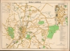
1950 Malay Surveyor General Map of Kuala Lumpur


This item has been sold.
Kuala Lumpur.
The growth of an international capital.
Choose a Collection:
- Digital Map Information
- Suitable for large format printing
- File Size: 1352.77 MB
- File Type: ZIP / TIFF
- ICC color profile embedded
- Delivered instantly via download link
This Item
Enquire
The growth of an international capital.
This is a large-scale 1950 map of Kuala Lumpur produced by the Survey Department of the Federation of Malaya. It showcases the city as Malaya (Malaysia) transitioned towards independence, with Kuala Lumpur as its capital. It showcase a multi-ethnic, multidenominational city as reflected in the buildings: Confucian, Malay, and Islamic schools; Masonic, Chinese, and Malay Assembly Halls; and houses of worship for Christians, Muslims, Sikhs, and more.Historical Context
Kuala Lumpur grew from humble and recent origins in the late 19th century on the back of the very productive rubber trade in the countryside surrounding the city. The Klang River and several railways provided access to the Straits of Malacca and from there on to global markets. The availability of rubber made the region a target for attack and it was occupied by Japanese troops in the early days of the Pacific War, scarcely a month after the Pearl Harbor attack. The city's Chinese population suffered terrible atrocities, akin to the 'Sook Ching' massacres in Singapore, as the Japanese saw any ethnic Chinese as likely insurgents. Other residents were imprisoned or sent as forced laborers on wartime infrastructure projects such as the Burma Railway. This map was produced in the period of postwar recovery, as Malaya, with Kuala Lumpur as its capital, moved gradually towards independence within the British Commonwealth.Publication History and Census
This map was produced by the Survey Department of the Federation of Malaya in 1950. This edition of the map is only listed among the holdings of the University of Michigan, while other (later) editions are held by eight other institutions in North America and Singapore.Condition
Very good. Some wear on old fold lines.
References
OCLC 1194692377.