
1976 Al-Saidan City Plan or Map of Kuwait City, Kuwait


Kuwait City / مدينة الكويت.
The Transformation of Kuwait City.
The Transformation of Kuwait City.
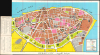
This is an unrecorded 1976 large-format city plan or map of Kuwait City, Kuwait, prepared by Hamad Al-Saidan. It was published as Kuwait City was emerging as one of the most modern, cosmopolitan cities in the Arab World after a wholesale transformation following Kuwait's independence in 1961.A Closer Look
The map is oriented with north towards top-right. Color-shading is used to distinguish different types of land and land use, including brown for old buildings and empty land. At this time, the city was in the process of demolishing old, mud structures and replacing them with taller concrete buildings and greenspace, most notably the 'green belt' (now the Al Shaheed Park and Al-Soor Gardens), which separated the city from what was its hinterland when planned in the 1960s. Aside from land use, the map also indicates street names, which are also listed in an index at left corresponding to a grid surrounding and overlying the map. Additional sites such as hospitals, mosques, cemeteries, and commercial centers are also indicated. At bottom-left is a map of the city center and its surrounding suburban areas in the Capital Governorate, such as Dasma, Mansouria, and Shamiya. Nearby, the building marked 'K.B.C. and TV' (الإذاعة والتلفزيون) is now the Ministry of Information.Historical Context
This map was produced during a golden age for Kuwait City, a period defined by unprecedented economic growth and rapid transformation following the country's independence in 1961. Fueled by skyrocketing oil revenues, the government launched ambitious master plans that dismantled the old, mud-brick walled town to make way for a glittering, modern metropolis. The historic city walls were replaced by expansive ring roads, commercial high-rises, and decentralized residential neighborhoods. Kuwait City became the vibrant, pioneering hub of the Arabian Gulf during these two decades. The city embraced bold, modernist architecture, a movement encapsulated by the construction of the iconic Kuwait Towers (not indicated here), which were constructed between 1971 and 1976, opening to the public in 1979, as a symbol of national progress and economic triumph. Beyond the concrete and glass, the capital fostered a highly progressive social and intellectual climate. With the region's first established constitution, an active parliament, a thriving independent press, and a booming arts and theater scene, 1970s Kuwait City stood as a cosmopolitan beacon of Arab modernity and financial influence.Publication History and Census
This map was prepared by Hamad Al-Saidan and published in London in 1976 with the aim of encouraging travel to Kuwait. It is unrecorded in institutional collections and has no known history on the market.Cartographer
Hamad Muhammed Al-Saidan (حمد محمد السعيدان; November 25, 1939 - August 27, 1991) was a prominent Kuwaiti researcher and historian. Al-Saidan was born in Kuwait City. His father was a carpet merchant as well as a pious and devout Muslim, leading Hamad to study the Quran, Islamic jurisprudence, and related topics. He attended high school but not graduating due to taking a job at Kuwait Radio (إذاعة الكويت). Soon afterwards, he went to Britain to study English and topographic drawing before returning to Kuwait in 1959 to again work at Kuwait Radio, which was the only local station in operation, radio signals otherwise coming from Baghdad or Kuwait. In 1962, Al-Saidan was transferred to work at the Radio station's library, which allowed him to access a wide range of information. In 1963, due to his education and language skills, he was hired to work at Kuwait's nascent Ministry of Foreign Affairs. In 1965, he was assigned to diplomatic work in Nairobi, Kenya, where he wrote a primer for Kuwaitis to understand the outside world (العالم حقائق وأرقام), as well as the first edition of his most influential book, The Concise Kuwaiti Encyclopedia (الموسوعة الكويتية المختصرة), first published in 1970 and, despite its title, consisting of three volumes of more than 1,600 pages. In 1972, he was sent to the critically important Kuwaiti Embassy in London, where he would work for the next fourteen years as a media attaché. During his time in London, he published many works relating to history and geography, including maps and street guides for Kuwait City, as well as works on vexillology and philately. In 1985, Al-Saidan returned to Kuwait to work as Secretary-General of the library of the Ministry of Foreign Affairs. He died in 1991 while seeking medical treatment in London, but wrote continuously until his death, fired by patriotic fervor in the wake of Iraq's 1990 invasion of Kuwait. Al-Saidan compiled a considerable personal library including rare books and manuscripts, though sadly much of it was damaged or destroyed during the 1990 Iraqi invasion. After his death, the surviving works were distributed among several libraries and research institutions in Kuwait. Further Details...
Condition
Excellent. Visible folds.