
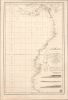
1800 Desposito Hidrgrafico Chart of the Coast of Peru and Southern Panama

Spain's Answer to Cook and Laperouse.
- Digital Map Information
- Suitable for large format printing
- Full resolution TIFF file
- ICC color profile embedded
- Delivered instantly via download link
Spain's Answer to Cook and Laperouse.
This is an 1800 maritime map or nautical chart of the northern part of the Pacific Coast of South America, prepared by Felipe Bauzá y Cañas and published by the Deposito Hidrografico (Direccion Hidrografía). Bauzá has been the main hydrographer on the Alexandro Malaspina Expedition (1789 - 1794), a Spanish effort to chart the western coast of America and explore the Pacific Ocean, akin to the slightly earlier British and French voyages led by James Cook and Lapérouse, respectively.A Closer Look
The chart covers from Coiba (Quibo) Island and the Gulf of Panama in the north to northern Peru in the south, taking in the coasts of today's Colombia and Ecuador. The tracks of Malaspina's two corvettes, the Descubierta and the Atrevida, are marked with each day recorded, including a point where the two ships diverged near top. Soundings are indicated throughout (even in the Chiriquí Lagoon on Panama's Atlantic side at top), as are sandbanks, anchorages, hazards, coastal features, the locations of astronomical observations, and some inland features such as mountains, rivers, and important cities or towns. Five vignette illustrations are included as navigational aids. Cadiz (more specifically, the Real Instituto y Observatorio de la Armada) is employed as the Prime Meridian.Malaspina Expedition
Setting off from Cadiz in 1789, the five-year Malaspina Expedition was the most important Spanish voyage of discovery of the 18th century. Aboard the two corvettes, Malaspina and his subordinate José de Bustamante y Guerra sailed from Spain to the Pacific, surveying both the physical coasts and the political landscape of the Spanish Empire in America and the Philippines. The leg of the voyage depicted here took place between late September 1790 and early January 1791. After further exploration of the Pacific, from Nootka to Manila to Australia, the fleet returned to Cadiz in September 1793.Malaspina's Exile and Silencing
On his return, Malaspina was well-received by King Charles IV and Prime Minister Manuel de Godoy, who promoted him to fleet-brigadier. But when he submitted his political review of the Empire to the government, it was deemed politically volatile for his recommendation that Spain free its colonies - among other absurdities! - and he was not permitted to publish. Malaspina complained vehemently in Madrid newspapers, whilst joining in a conspiracy to oust Godoy. He was accused of his role in the conspiracy, stripped of rank, and imprisoned from 1796 to 1802. When he was freed - partially under pressure from Napoleon - he was exiled from Spain.Due both his political disfavor and the economic constraints of Spain's war with revolutionary France, Malaspina's account remained unpublished. Nonetheless, several charts based upon the expedition's discoveries were issued by the Dirección de Hidrografía, some of which were later translated; see, for example, our Peru-faden-1804, as well as the 1821 Depot General de la Marine French translation of the present chart, held by the David Rumsey Historical Map Collection ('Carte reduite de la cote occidentale de l'Amerique,' Rumsey 0233.014).
Publication History and Census
This map was prepared by Felipe Bauzá y Cañas and engraved by Fernando Selma for the Deposito Hidrografico (Direccion Hidrografía) in 1800. It is held by eight institutions in the OCLC as well as the David Rumsey Historical Map Collection.Cartographers
The Direccion Hidrografía (1787 - 1927), also known as the Deposito Hydrografico and the Direction de Hidrografía, was the Spanish equivalent of the British Admiralty or the U.S. Coast Survey. This organization, founded in 1787, was commissioned to collect and produce accurate nautical charts of all waters frequented by Spanish vessels. In essence, it replaced the Casa de la Contratación de las Indias (House of Trade of the Indies), which closed its doors in 1790. Like most such organizations, the Direccion Hidrografía marked a new age in cartography. Rather than simply collect charts created by navigators, explorers, and merchants, the Direccion Hidrografía worked closely with naval and military personnel to mount cartographic and hydrographic expeditions in pursuit of the most accurate hydrographical, astronomical, and geodetic measurements. The Direccion Hidrografía created a massive library of nautical charts that, though not nearly as common as similar nautical charts by the U.S. Coast Survey and British Admiralty, are highly desirable for the beauty of their manufacture as well as their accuracy and detail. The office was originally located on Calle Ballesta, but relocated to 36 Alcala, both in Madrid. After 1908 the Dirección was subsumed into other governmental agencies. In 1927 the Direccion was absorbed into the Institute and Observatory of San Fernando, located in Cadiz. The library of original maps, charts, and journals was transferred to the Naval Museum of Madrid - where it resides to this day. Further Details...
Felipe Bauzá y Cañas (February 17, 1764 - March 3, 1834) was a Spanish cartographer, navigator, and naval officer active in the late 18th and early 19th centuries. Bauzá was born on the Balearic Islands in the Mallorcan city of Palma. He attended the Spanish maritime college in Cartagena, Spain. He saw action during the Siege of Gibraltar (1779 - 1782), the capture of Port Mahón, and a campaign against the Moors (1783 - 1784). Exhibiting a proficiency in mathematics and draftsmanship, he subsequently trained as a hydrographer and cartographer under Vicente Tofiño (1732 – 1795), the premier Spanish nautical chartmaker of the day. Bauzá was the head cartographer on the Malaspina Expedition (1789 - 1794) to the Americas, Oceania, and Australasia. From 1797, he worked with the Depósito Hidrográfico / Dirección Hidrografica in Madrid, becoming head of said organization in 1815. Renowned as a cartographer, he was honored with the Russian Cross of St. Vladimir in 1816 and was elected a Foreign Member of the Royal Society of London in 1819. From about 1800, he began assembling a personal collection of maps and charts intended to form the backdrop of a series of definitive maps of Latin America. Political fate intervened with his plan. Bauzá was a supporter and leader of the of Rafael de Riego Revolution in 1820, and served the Cortes Generales during the Trienio Liberal ('Three Liberal Years', 1820 - 1823), as the deputy for Mallorca. After the fall of that regime, in 1823, he was sentenced to death by King Ferdinand VII. Bauzá fled to England in that year, taking with him his nautical charts and other geographical source materials. Bauzá and his family struggled in London, attempting to support themselves by publishing his cartography and selling parts of his collection to the British Admiralty's Hydrographic Office. His death sentence was finally commuted in 1833, but before he could return to Spain, he died of a brain hemorrhage. He family was left in destitution and his widow Teresa Rivera y Bauzá, made ends meet by selling his map collections. Some went to foreign governments (Venezuela) but most are now part of the Bauzá collection in the British Library. Further Details...
Ferdinand Selma (Fernando Selma; 1752 - January 8, 1810) was a Spanish line engraver active in Madrid with the Direccion Hidrografía in the late 18th and early 19th centuries. Selma was born in Valencia and died in Madrid. His is best known for his engravings for his 1788 Illustrations de Relacion del ultimo viage al estracho de Magallanes. Further Details...
Condition
Good. Even toning, some foxing, few surface mends, some entering printed area.
References
Rumsey 4232.000. OCLC 956494165, 790705611, et al.