
1827 First Edition Greenwood Map of London, England

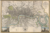
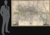
Map of London, from An Actual Survey made in the Years 1824, 1824 and 1826 by C. an J. Greenwood.
Grandest Cartographic Representation of Regency London.
- Digital Map Information
- Suitable for large format printing
- Full resolution TIFF file
- ICC color profile embedded
- Delivered instantly via download link
Grandest Cartographic Representation of Regency London.
This is the rare first edition of Christopher and John Greenwood's large-scale 1827 map of London, produced at the height of the Regency period, during which the city was being crafted into a neoclassical metropolis, driven by the Prince Regent (George IV) himself but realized by his favored architect, John Nash. Greenwood's map, in its grand presentation and monumental scope, is the essential cartographic expression of the Regency, and it is considered the largest and finest plan of London to appear in the 19th century.A Closer Look
This map is the result of a 3-year-long survey effort by brothers Christopher and John Greenwood. Coverage extends from Kentish Town in the north, to the River Lea, Greenwich, and Kensington. Vignette images in the lower corners illustrate Westminster Abbey and St. Paul's Cathedral. The map captures Thomas Cubitt's development of Belgravia, outlines new roads in Bayswater, and follows the 1826 completion of the Grand Surrey Canal.John Nash's Stamp on London
Architect John Nash (1752 - 1835), with the encouragement and support of the Prince Regent, undertook an array of projects which characterized the period, and which are evident on the map. As architect to the Office of Woods and Forests, he created a plan for Marylebone Park, which met with the Regent's approbation: today Regents' Park. Its prospective plan appears here, as the park was still being developed and would not open to the public until 1835. To connect the new park with the West End and Westminster, Nash also designed Regent Street: this thoroughfare was completed in 1826, and it is clearly marked here. It served another purpose, also extremely characteristic of the Regency period, to create a boundary between the well-heeled West End and the impoverished rookeries of SoHo.Regent's Canal, also spearheaded by Nash and completed in 1820, can be seen arching over London (and under it, via tunnel) from the Limehouse docks to the Grand Junction Canal at Paddington. It too was a reaction to the overfull central London, allowing river freight to be brought through the city while avoiding the congestion of its streets.
The expansive green spaces to the west of Regent's Street include St. James's Park (completed 1829), also developed by Nash on the orders of the Regent. Oddly, Trafalgar Square, also conceived by Nash, does not appear - although the area between Pall Mall East and Cockspur Street is uncharacteristically ill-defined. Nash's death stalled that project, and it may be that a plan of it was not yet available when this map was engraved.
Other features include an extremely early instance of the proposed Thames Tunnel, which was not completed until 1843. The array of Thames bridges includes both the old and new London Bridges, the Southwark Bridge, Blackfriars Bridge, Waterloo Bridge, Westminster Bridge, Vauxhall Bridge, and the Battersea Bridge. The Greenwood map was not superseded for detail and accuracy until the emergence of the Ordnance Survey in the mid-19th century.
Publication History and Census
This map was engraved in six plates for Greenwood, Pringle and Company in 1827 by James and Josiah Neele. The first edition can be distinguished by the dedication to King George located at the bottom center; in later editions it was moved to the upper right. Good examples of the first edition, as here, are rare on the market.Cartographers
Christopher Greenwood (May 21, 1786 - March 25, 1825) was a British surveyor and mapmaker active in Wakefield and London in the early 19th century. He was born in Gisburn, Yorkshire. He lived and worked in Wakefield until 1818, when he moved to London. He partnered with George Pringle and Pringle's son George, to publish maps. This partnership lasted until 1828, when it was dissolved. Pringle was imprisoned for debt in 1834 and his map plates sold at auction in 1840. He worked extensively with his brother John Greenwood (1791 - 1867) and the engraver Samuel John Neele. He is best known for his enormous 1827 wall map of London. Further Details...
John Greenwood (March 25, 1791 - October 1, 1867) was a British surveyor, mapmaker, and publisher active in London in the early to mid-19th century. John was the younger brother of fellow mapmaker, Christopher Greenwood (1786 - 1825). He was born in Gisburn, Yorkshire. He worked for a time in London with his brother John, and George Kemp in a surveying partnership. The Kemp partnership was dissolved in 1827, curiously around the same time the Greenwood brothers issued their monumental plan of London. Further Details...
Josiah Neele (March 30, 1804 - March 22, 1876) was a British map engraver, printer, and publisher active in London during the middle part of the 19th century. Neele was the son of Samuel John Neele (1758 - 1824), also a prominent map engraver. He apprenticed under his father along with Ebenezer Stalker (1780 - 1847) with whom he briefly partnered until 1825. At that time, he went into business with his uncle, George Neele, and his brother, James Neele. George retired in 1826, ending that partnership, after which the brothers published until 1829 under the imprint of 'James and Josiah Neele'. Josiah subsequently continued the business under his own name, operating from their former offices at 352 Strand, until 1836, when he declared bankruptcy. In 1845 he married Eliza Atwood of Haverfordwest and in the wedding documents he is described as a stationer. He retired to Wiltshire in 1871 and died five years later in 1876. Further Details...
Condition
Good. Six sheets joined for framing. Few marginal mends, one entering surface of map at top left and one at lower right; mend at bottom center entering border.
References
Howgego, James L., Printed Maps of London circa 1553-1850, #309. Rumsey 10241.001.