1794 Carey / Lewis Map of Maine
Maine-lewis-1794$1,200.00
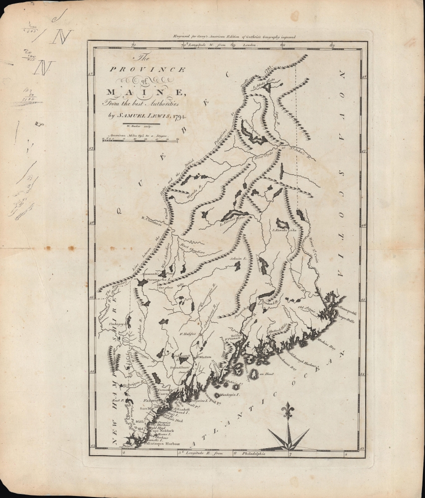

Title
The province of Maine, from the best authorities.
1794 (dated) 14.5 x 9.75 in (36.83 x 24.765 cm) 1 : 1520640
1794 (dated) 14.5 x 9.75 in (36.83 x 24.765 cm) 1 : 1520640
Description
A fascinating 1794 map of the 'Province of Maine' by Samuel Lewis and engraved by William Barker for Matthew Carey's American Edition of Guthrie's Geography improved, the first atlas published in the American Republic. It depicts the territory in the years just following independence, with borders that remained disputed and would later be shifted southwards as part of a compromise with Great Britain.
The border between Maine and the neighboring British possessions in North America (future Canada) are noted according to the Treaty of 1783, which ended the American Revolution. However, the border was not well demarcated, and remained a lingering issue in Anglo-American relations that was not settled until after the bloodless Aroostook 'War' of 1838-1839, when a treaty agreement shifted the border southwards from what is displayed here. Thus, for example, the Chaudière River flowing into the 'Agamuntic Pond' (Lac Mégantic) at left-center in now located within Quebec.
At this time, the English-speaking White population of Maine was mostly confined to the southern coastline, while the vast interior was sparsely populated by Native Americans and some French-speaking fur traders. Multiple wars had been fought in the 17th and 18th centuries against Native Americans and the French to claim these lands for Britain. During the American Revolution and again during the War of 1812, the British attempted to establish a Loyalist colony in Maine called 'New Ireland.' Though these efforts failed (resulting in the creation of New Brunswick), Maine remained exposed to foreign attack, and the response of the authorities in Massachusetts to these threats, which locals viewed as insufficient, was one important motivation for independent statehood.
Portland, now the largest city in Maine, was at this point an offshoot of Falmouth, which had been burned in the early days of the American Revolution, enraging the colonists and reducing the chances of conciliation. In the years after the Revolution, Portland grew quickly as a trading port and was designated the capital when Maine became a state in 1820, before the capital was moved to Augusta twelve years later.
Several forts appear, generally constructed during the French and Indian War and later being damaged or destroyed during the American Revolution. Fort Western, at bottom center, was located at the point on the Kennebec River that developed into Augusta, the state's eventual capital. Fort Halifax was located at the meeting of the Kennebec and Sebasticook (here as Sabastecoog) River, where the town of Winslow later grew. Fort Pownall is now within the town of Stockton Springs.
A Closer Look
The title refers to Maine somewhat anachronistically as a province; it was at this time district of Massachusetts. Mountains, rivers, and lakes are indicated, with names and spellings that were later standardized, sometimes beyond the point of recognition. One coastal road leads from Massachusetts and New Hampshire to Pownalboro, now Dresden. The White Mountains of neighboring New Hampshire are noted as the 'White Hills,' a common designation at the time.The border between Maine and the neighboring British possessions in North America (future Canada) are noted according to the Treaty of 1783, which ended the American Revolution. However, the border was not well demarcated, and remained a lingering issue in Anglo-American relations that was not settled until after the bloodless Aroostook 'War' of 1838-1839, when a treaty agreement shifted the border southwards from what is displayed here. Thus, for example, the Chaudière River flowing into the 'Agamuntic Pond' (Lac Mégantic) at left-center in now located within Quebec.
At this time, the English-speaking White population of Maine was mostly confined to the southern coastline, while the vast interior was sparsely populated by Native Americans and some French-speaking fur traders. Multiple wars had been fought in the 17th and 18th centuries against Native Americans and the French to claim these lands for Britain. During the American Revolution and again during the War of 1812, the British attempted to establish a Loyalist colony in Maine called 'New Ireland.' Though these efforts failed (resulting in the creation of New Brunswick), Maine remained exposed to foreign attack, and the response of the authorities in Massachusetts to these threats, which locals viewed as insufficient, was one important motivation for independent statehood.
Portland, now the largest city in Maine, was at this point an offshoot of Falmouth, which had been burned in the early days of the American Revolution, enraging the colonists and reducing the chances of conciliation. In the years after the Revolution, Portland grew quickly as a trading port and was designated the capital when Maine became a state in 1820, before the capital was moved to Augusta twelve years later.
Several forts appear, generally constructed during the French and Indian War and later being damaged or destroyed during the American Revolution. Fort Western, at bottom center, was located at the point on the Kennebec River that developed into Augusta, the state's eventual capital. Fort Halifax was located at the meeting of the Kennebec and Sebasticook (here as Sabastecoog) River, where the town of Winslow later grew. Fort Pownall is now within the town of Stockton Springs.
Publication History and Census
This map was drafted Samuel Lewis in 1794 and engraved by William Barker for the first (1795) edition of Carey's General Atlas (also known as the American Edition of Guthrie's Geography improved). The prevalence of the map is difficult to determine since it is sometimes cataloged independently and sometimes with the atlas, and because the various early printings of Carey's atlas have led to it being dated anywhere from 1794 - 1796. The map is independently cataloged by the American Antiquarian Society, Newberry Library, the University of Michigan, the Boston Public Library, the Osher Map Library at the University of Southern Maine, the University of Maine, and the Bangor Public Library, while the entire atlas is somewhat more widely distributed. Doodles, penmanship practice, and mathematical problems appear in the margin at top-left, suggesting that this particular map might have belonged to a schoolchild early in its existence.CartographerS
Samuel Lewis (c. 1754 - 1822) was an American engraver, cartographer, draftsman, and geographer active in Philadelphia in the first of the 19th century. Though is place of birth is uncertain, most agree that Lewis emigrated from Dublin, Ireland, in the late 18th century. Lewis' earliest cartography work was produced in partnership with the well-known Philadelphia publishers Matthew Carey and Henry Schenk Tanner. In 1804, with the intention of republishing high quality English maps in the United States, Lewis partnered with the eminent British map publisher Arron Arrowsmith. Their first joint publication was A New and Elegant General Atlas, but many others followed including an American edition of Arrowsmith's important double hemisphere wall map of the world. Arrowsmith also worked with Jedidiah Morse, among other important American cartographers of the period. Ralph Brown considers Lewis to be "the most enterprising commercial map-maker of the period … " Lewis is best known for his map related to the expedition of Meriwether Lewis (no relation) and William Clark. In 1814 Lewis, copying directly from William Clark's manuscript, issued A Map of Lewis and Clark's Tracks across the Western Portion of North America. This important document was the first published map derived from the Lewis and Clark Expedition and profoundly transformed the cartography of the American northwest. Samuel Lewis of Philadelphia should not be confused with Samuel Lewis of London, another cartographer active during roughly the same period. More by this mapmaker...
William Barker (June 29, 1770 - April 19, 1805) was an engraver active in Philadelphia un the late 18th and early 19th centuries. Barker was born in Philadelphia, the son of Elihu Barker (17?? - 1792). Both father and son worked for the firm of Mathew Carey (1760 - 1839) and engraved maps for Carey's American Atlas, considered the first general atlas published in America. He appears in Philadelphia directories for 1795 - 1796 and 1800 - 1809. His business may have been carried on by a son of the same name, but it is unclear. Learn More...
Matthew Carey (January 28, 1760 - September 16, 1839) was a Dublin born publisher who established himself in Philadelphia in the late 18th and early 19th century. A young man of socially progressive views, Carey's first known publication, produced when he was but 17 years old, was a pamphlet criticizing dueling. Another pamphlet, issued in the same year, attacked the Irish penal code. Shortly afterwards, in 1779, legal issues, possibly arising from his liberal political activism, forced Carey to flee to Paris. In Paris, Carey had the good fortune to befriend the visiting American diplomat and founding father, Benjamin Franklin (1706 - 1790). As an Irishman chafing under the rule of England, Carey sympathized with and admired the American revolutionary. The liberally minded pair struck up a lifelong friendship and Carey was hired to work at Franklin's press in Passy, France. A year later, Carey returned to Ireland and resumed his politically provocative publishing career with The Freemans's Journal and The Volunteer's Journal. It didn't take long for political pressure to once again force Carey from Ireland - this time to America (1784). Although largely without funds, Carey convinced Gilbert du Motier, Marquis de Lafayette (1757 - 1834), who he knew from Franklin's Paris circle, to lend him funds to establish a new publishing concern in Philadelphia. Despite this loan, Carey's firm remained under financed and opened on a shoestring budget. It was most likely his limited budget that led Carey to some of his most important publishing innovations. At the time cartographic publishing was dominated by large printing houses in London and Paris where most, if not all, of the work was completed in house. Without the finances to emulate this large publishing houses, Carey was forced to outsource much of his publishing work. This set the stage for subsequent American publishers who, in order to compete effectively with European firms, relied on an often bewildering network of alliances and collaborations. Carey was also a master of republishing many of his own maps in multiple different atlases and formats to maximize their profitability. His most important work is without a doubt the 1795 issue of the American Atlas the first atlas to be published in America. Carey died in 1839 but was succeeded by his son Henry Charles Carey (1793 - 1879) who, in partnership with his brother-in-law Isaac Lea (1792 - 1886), published numerous important maps and atlases under the Carey and Lea, Lea Brothers, and Lea and Blanchard imprints. Learn More...
William Guthrie (1708 - March 9, 1770) was a Scottish historian, journalist, and writer. Born in Brechin, he studied at Aberdeen University with the idea of becoming a parochial schoolmaster. Instead, in 1730, he elected to settle in London and try his hand at literature. He covered parliamentary debates f or the Gentleman's Magazine and soon earned a reputation for being a political writer. He published several scholarly works, including a History of England from the Invasion of Julius Caesar to 1688 in four volumes, and, most notably, his Geographical Historical, and Commercial Grammar. Learn More...
Source
Carey, M., Carey's General Atlas, (Philadelphia: Carey), 1795.
Condition
Very good. Wide margins. Verso reinforcement. Some toning, foxing, and pencil marks to margins.
References
Rumsey 2542.002, OCLC 55520324, 852229900, 1031452929, 984129786.