1795 Carey / Lewis Map of Maryland, with the 'City of Washington'
Maryland-carey-1795$600.00

Title
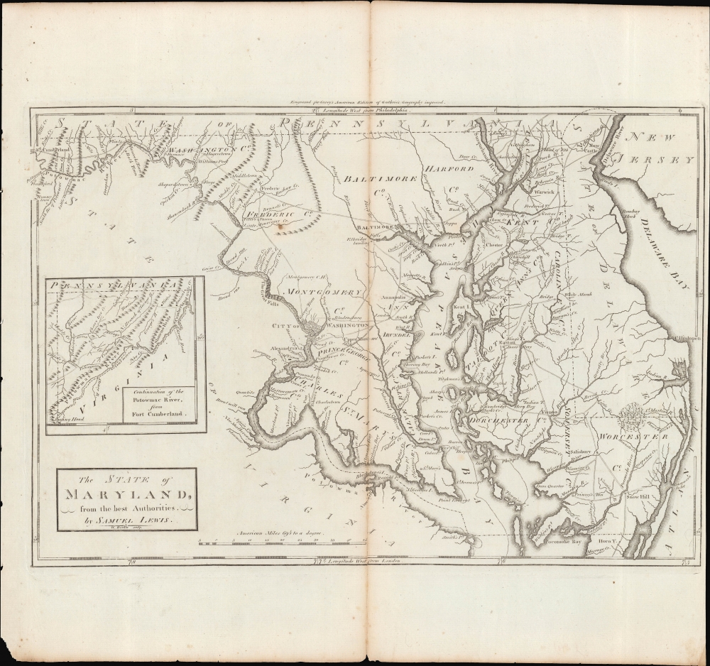
The State of Maryland, from the Best Authorities.
1795 (undated) 11 x 16 in (27.94 x 40.64 cm) 1 : 760320
1795 (undated) 11 x 16 in (27.94 x 40.64 cm) 1 : 760320
Description
An important map of Maryland from the early days of the American Republic, this 1795 work was drawn by Samuel Lewis and engraved by William Barker for inclusion in Matthew Carey's Carey's American Edition of Guthrie's Geography Improved, the first atlas published in the United States.
A Closer Look
Coverage includes Maryland, Delaware, and portions of Pennsylvania, New Jersey, and Virginia. Maryland's counties are labelled, though their borders are not drawn. Cities and towns, roads, areas of elevation, waterways, coastal shoals, state boundaries, and other features are indicated throughout. Fort Cumberland, an important outpost in the French and Indian War where George Washington led the remnants of the disastrous Braddock Expedition in 1755, is located in the far northwest of the state. At left is an inset map of the Maryland Panhandle west of Ft. Cumberland. Mount Vernon, the estate of Washington, appears south of Alexandria, Virginia.The Early Days of Washington, D.C.
Especially prominent here are Baltimore, at the time one of the largest cities in the new republic, and the 'City of Washington,' which had only been designated and surveyed at the start of the decade. The planning of the city moved ahead swiftly under the direction of Pierre Charles L'Enfant, and later Andrew Ellicott, who had already undertaken significant work surveying the district's boundaries. Nevertheless, the city seen here, along with neighboring Georgetown, is a projection of expected future growth in tandem with L'Enfant's plan rather than a reflection of the city at the time of publication.Publication History and Census
This map was drawn by Samuel Lewis and engraved by William Barker for inclusion in Matthew Carey's Carey's American Edition of Guthrie's Geography Improved, published in Philadelphia in 1795. The same map also appeared in the largely overlapping Carey's American Atlas, published soon afterwards. Regardless of printing, roughly thirteen institutions independently catalog this map in the OCLC, though the intermingling of digital and physical examples makes a precise census difficult.CartographerS
Matthew Carey (January 28, 1760 - September 16, 1839) was a Dublin born publisher who established himself in Philadelphia in the late 18th and early 19th century. A young man of socially progressive views, Carey's first known publication, produced when he was but 17 years old, was a pamphlet criticizing dueling. Another pamphlet, issued in the same year, attacked the Irish penal code. Shortly afterwards, in 1779, legal issues, possibly arising from his liberal political activism, forced Carey to flee to Paris. In Paris, Carey had the good fortune to befriend the visiting American diplomat and founding father, Benjamin Franklin (1706 - 1790). As an Irishman chafing under the rule of England, Carey sympathized with and admired the American revolutionary. The liberally minded pair struck up a lifelong friendship and Carey was hired to work at Franklin's press in Passy, France. A year later, Carey returned to Ireland and resumed his politically provocative publishing career with The Freemans's Journal and The Volunteer's Journal. It didn't take long for political pressure to once again force Carey from Ireland - this time to America (1784). Although largely without funds, Carey convinced Gilbert du Motier, Marquis de Lafayette (1757 - 1834), who he knew from Franklin's Paris circle, to lend him funds to establish a new publishing concern in Philadelphia. Despite this loan, Carey's firm remained under financed and opened on a shoestring budget. It was most likely his limited budget that led Carey to some of his most important publishing innovations. At the time cartographic publishing was dominated by large printing houses in London and Paris where most, if not all, of the work was completed in house. Without the finances to emulate this large publishing houses, Carey was forced to outsource much of his publishing work. This set the stage for subsequent American publishers who, in order to compete effectively with European firms, relied on an often bewildering network of alliances and collaborations. Carey was also a master of republishing many of his own maps in multiple different atlases and formats to maximize their profitability. His most important work is without a doubt the 1795 issue of the American Atlas the first atlas to be published in America. Carey died in 1839 but was succeeded by his son Henry Charles Carey (1793 - 1879) who, in partnership with his brother-in-law Isaac Lea (1792 - 1886), published numerous important maps and atlases under the Carey and Lea, Lea Brothers, and Lea and Blanchard imprints. More by this mapmaker...
Samuel Lewis (c. 1754 - 1822) was an American engraver, cartographer, draftsman, and geographer active in Philadelphia in the first of the 19th century. Though is place of birth is uncertain, most agree that Lewis emigrated from Dublin, Ireland, in the late 18th century. Lewis' earliest cartography work was produced in partnership with the well-known Philadelphia publishers Matthew Carey and Henry Schenk Tanner. In 1804, with the intention of republishing high quality English maps in the United States, Lewis partnered with the eminent British map publisher Arron Arrowsmith. Their first joint publication was A New and Elegant General Atlas, but many others followed including an American edition of Arrowsmith's important double hemisphere wall map of the world. Arrowsmith also worked with Jedidiah Morse, among other important American cartographers of the period. Ralph Brown considers Lewis to be "the most enterprising commercial map-maker of the period … " Lewis is best known for his map related to the expedition of Meriwether Lewis (no relation) and William Clark. In 1814 Lewis, copying directly from William Clark's manuscript, issued A Map of Lewis and Clark's Tracks across the Western Portion of North America. This important document was the first published map derived from the Lewis and Clark Expedition and profoundly transformed the cartography of the American northwest. Samuel Lewis of Philadelphia should not be confused with Samuel Lewis of London, another cartographer active during roughly the same period. Learn More...
William Barker (June 29, 1770 - April 19, 1805) was an engraver active in Philadelphia un the late 18th and early 19th centuries. Barker was born in Philadelphia, the son of Elihu Barker (17?? - 1792). Both father and son worked for the firm of Mathew Carey (1760 - 1839) and engraved maps for Carey's American Atlas, considered the first general atlas published in America. He appears in Philadelphia directories for 1795 - 1796 and 1800 - 1809. His business may have been carried on by a son of the same name, but it is unclear. Learn More...
William Guthrie (1708 - March 9, 1770) was a Scottish historian, journalist, and writer. Born in Brechin, he studied at Aberdeen University with the idea of becoming a parochial schoolmaster. Instead, in 1730, he elected to settle in London and try his hand at literature. He covered parliamentary debates f or the Gentleman's Magazine and soon earned a reputation for being a political writer. He published several scholarly works, including a History of England from the Invasion of Julius Caesar to 1688 in four volumes, and, most notably, his Geographical Historical, and Commercial Grammar. Learn More...
Source
Carey, M., Carey's American Edition of Guthrie's Geography Improved, (Philadelphia) 1795.
Condition
Fair. Mended along centerfold split. Slight soiling, slight foxing on verso.
References
Rumsey 2542.012. OCLC 5673746, 1031455441, 5565258, 1013289664, 238356663.