This item has been sold, but you can get on the Waitlist to be notified if another example becomes available, or purchase a digital scan.
1896 Imfled Map of Mont-Blanc Mountian Range, Alps, Switzerland
Montblanc-imfeld-1896$500.00

Title
Le Chaine du Mont-Blanc.
1896 (dated) 23 x 42 in (58.42 x 106.68 cm) 1 : 50000
1896 (dated) 23 x 42 in (58.42 x 106.68 cm) 1 : 50000
Description
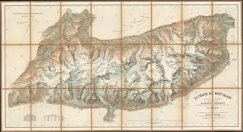
Generally known as 'The Imfeld Map', this is a dramatic and stunning 1896 Xaver Imfeld chromolithograph map of the Mont Blanc Mountain Range in Switzerland's Alps - at the time the finest map of the region yet produced. The map is oriented slightly to the northwest and is centered on the peak of Mont Blanc itself. Coverage extends from Bon-Nant River in France to Orsières and from Gillot to Courmayeur. The map was highly praised when it was produced by journals of the time,
To this faultless production all explorers of the Chian are deeply indebted, and for the first time the Mont du Brouillard, the Glacier du Mont Blanc, the Rochers du Mont Blanc, the Glacier du Dôme, and the Aiguilles Grises are all beautifully delineated with scrupulous fidelity to nature. (Mathews, C. E., Annals of Mont Blanc, page 216)The whole employs the unique Swiss-style shading techniques employed by the engraver, Kümmerly, to display that country's intense topography.
Chromolithography
Chromolithography is a color lithographic technique developed in the mid-19th century. The process involved using multiple lithographic stones, one for each color, to yield a rich composite effect. Oftentimes the process would start with a black basecoat upon which subsequent colors were layered. Some chromolithographs used 30 or more separate lithographic stones to achieve the desired effect. Chromolithograph color could also be effectively blended for even more dramatic effects. The process became extremely popular in the late 19th and early 20th centuries, when it emerged as the dominate method of color printing.Publication History and Census
This map was ordered by Albert Barbey, President of the Diablerets Section of the Swiss Alpine Club. It was executed by the Swiss cartographer and topographical engineer Xaver Imfeld based on measurements by Louis Kurz, also of the Swiss Alpine Club. The whole was masterfully engraved and printed in Bern, Switzerland via chromolithograph technique by Hermann Kümmerly and Rudolf Leuzinger. The map employs the iconic Kümmerly topographical shading techniques. The map went through several editions to about 1940, this being the first. While we have identified about 7 examples in European, predominantly Swiss, institutions, and a couple of sale records, this map remains rare on the private market.CartographerS
Xaver Imfeld (April 21, 1853 - February 21, 1909) was a Swiss engineering topographer and cartographer. After the relocation of the family in 1867 to Lucerne, studied at the industrial school there, demonstrating topographical talent there. In the fall of 1872 he began training as an engineer topographer at the Swiss Federal Polytechnic in Zurich. He would grow to become one of the most important Swiss landscape painters, relief artist, cartographer and planner of mountain railways of his time. From 1876 to 1890 he worked for the Federal Topographic Bureau. More than twenty sheets of the Siegfried Atlas are his work. He drew over forty mountain panoramas, modeled thirteen Alpine reliefs and was responsible for numerous engineering projects. In 1888 Imfeld opened his own office in Zurich as a freelance engineer and private topographer. His works included a relief map of central Switzerland in 1887 and the La Chaine du Mont Blanc in 1890. More by this mapmaker...
Hermann Kümmerly (September 6, 1857 - April 29, 1905) was a Swiss painter, lithographer, and cartographer. Kümmerly was born in Bern. He apprenticed as a lithographer under his father Gottfried, and also studied as a painter. He worked for a time for the Swiss Confederation's Topographic Bureau, which did not have its own printing company. In conjunction with Rudolf Leuzinger, the Kümmerly printing office gradually specialized in map printing. His maps became renowned for their vivid and accurate presentation of topography and in his naturalistic use of color in maps. He became particularly well known for his large school wall map of Switzerland, which has been hanging in virtually every school in Switzerland from 1903 until today. In 1898, his brother-in-law Otto Julius Frey joined the company as cartographer and co-owner, who now took the name Kümmerly and Frey. In 1931, Walter Kümmerly and Max Frey, the sons of the two predecessors, took over the management and skillfully steered the company through the years of crisis and World War II, despite the prohibition on map printing. In the post-war period, production shifted back to map production and book production with geographic themes. Since 1980, the fourth generation has been represented in the company management with Barbara Elisabeth Peters. Learn More...
Louis Kurz (1854 - 1942) was a Swiss professional musician and a mountaineer. Born in Neuchâtel, Switzerland, Kurz was the author of the excellent Guide de la Chaîne du Mont Blanc, which was published in 1892. He explored throughout the region and was known for his work as a surveyor. Learn More...
Condition
Very good. Slight toning. Dissected and mounted on old linen. Old linen stable.
References
OCLC 638559519.