Digital Image: 1896 Imfled Map of Mont-Blanc Mountian Range, Alps, Switzerland
Montblanc-imfeld-1896_d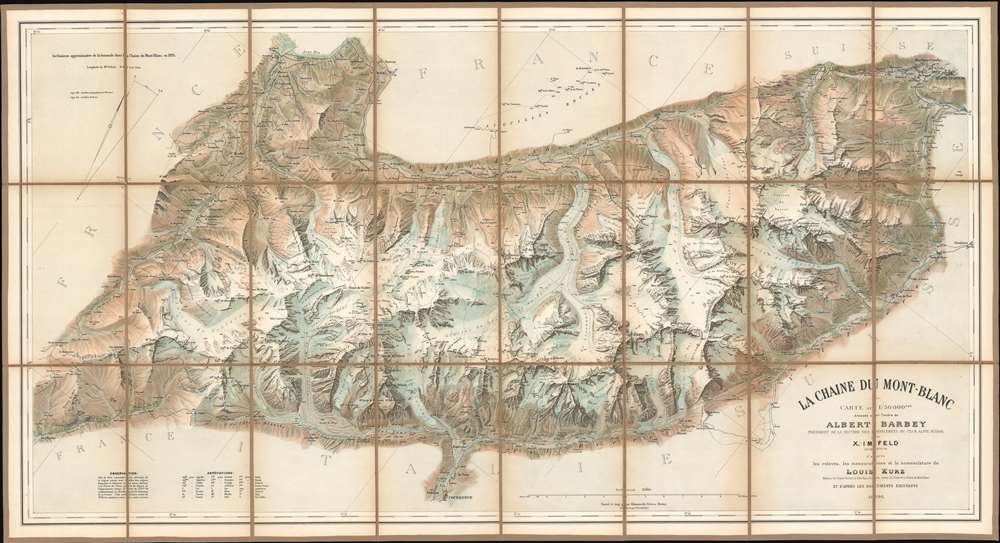

Title
Le Chaine du Mont-Blanc.
1896 (dated) 23 x 42 in (58.42 x 106.68 cm) 1 : 50000
1896 (dated) 23 x 42 in (58.42 x 106.68 cm) 1 : 50000
Description
FOR THE ORIGINAL ANTIQUE MAP, WITH HISTORICAL ANALYSIS, CLICK HERE.
Digital Map Information
Geographicus maintains an archive of high-resolution rare map scans. We scan our maps at 300 DPI or higher, with newer images being 600 DPI, (either TIFF or JPEG, depending on when the scan was done) which is most cases in suitable for enlargement and printing.
Delivery
Once you purchase our digital scan service, you will receive a download link via email - usually within seconds. Digital orders are delivered as ZIP files, an industry standard file compression protocol that any computer should be able to unpack. Some of our files are very large, and can take some time to download. Most files are saved into your computer's 'Downloads' folder. All delivery is electronic. No physical product is shipped.
Credit and Scope of Use
You can use your digial image any way you want! Our digital images are unrestricted by copyright and can be used, modified, and published freely. The textual description that accompanies the original antique map is not included in the sale of digital images and remains protected by copyright. That said, we put significant care and effort into scanning and editing these maps, and we’d appreciate a credit when possible. Should you wish to credit us, please use the following credit line:
Courtesy of Geographicus Rare Antique Maps (https://www.geographicus.com).
How Large Can I Print?
In general, at 300 DPI, you should at least be able to double the size of the actual image, more so with our 600 DPI images. So, if the original was 10 x 12 inches, you can print at 20 x 24 inches, without quality loss. If your display requirements can accommodate some loss in image quality, you can make it even larger. That being said, no quality of scan will allow you to blow up at 10 x 12 inch map to wall size without significant quality loss. For more information, it is best consult a printer or reprographics specialist.
Refunds
If the high resolution image you ordered is unavailable, we will fully refund your purchase. Otherwise, digital images scans are a service, not a tangible product, and cannot be returned or refunded once the download link is used.
Cartographer S
Xaver Imfeld (April 21, 1853 - February 21, 1909) was a Swiss engineering topographer and cartographer. After the relocation of the family in 1867 to Lucerne, studied at the industrial school there, demonstrating topographical talent there. In the fall of 1872 he began training as an engineer topographer at the Swiss Federal Polytechnic in Zurich. He would grow to become one of the most important Swiss landscape painters, relief artist, cartographer and planner of mountain railways of his time. From 1876 to 1890 he worked for the Federal Topographic Bureau. More than twenty sheets of the Siegfried Atlas are his work. He drew over forty mountain panoramas, modeled thirteen Alpine reliefs and was responsible for numerous engineering projects. In 1888 Imfeld opened his own office in Zurich as a freelance engineer and private topographer. His works included a relief map of central Switzerland in 1887 and the La Chaine du Mont Blanc in 1890. More by this mapmaker...
Hermann Kümmerly (September 6, 1857 - April 29, 1905) was a Swiss painter, lithographer, and cartographer. Kümmerly was born in Bern. He apprenticed as a lithographer under his father Gottfried, and also studied as a painter. He worked for a time for the Swiss Confederation's Topographic Bureau, which did not have its own printing company. In conjunction with Rudolf Leuzinger, the Kümmerly printing office gradually specialized in map printing. His maps became renowned for their vivid and accurate presentation of topography and in his naturalistic use of color in maps. He became particularly well known for his large school wall map of Switzerland, which has been hanging in virtually every school in Switzerland from 1903 until today. In 1898, his brother-in-law Otto Julius Frey joined the company as cartographer and co-owner, who now took the name Kümmerly and Frey. In 1931, Walter Kümmerly and Max Frey, the sons of the two predecessors, took over the management and skillfully steered the company through the years of crisis and World War II, despite the prohibition on map printing. In the post-war period, production shifted back to map production and book production with geographic themes. Since 1980, the fourth generation has been represented in the company management with Barbara Elisabeth Peters. Learn More...
Louis Kurz (1854 - 1942) was a Swiss professional musician and a mountaineer. Born in Neuchâtel, Switzerland, Kurz was the author of the excellent Guide de la Chaîne du Mont Blanc, which was published in 1892. He explored throughout the region and was known for his work as a surveyor. Learn More...
References
OCLC 638559519.