
1876 Viollet-le-Duc Two-Sheet Map of Mont Blanc, France and Italy

Le Massif du Mont Blanc.
Greatest Map of Mont Blanc Ever Made.
- Digital Map Information
- Suitable for large format printing
- Full resolution TIFF file
- ICC color profile embedded
- Delivered instantly via download link
Greatest Map of Mont Blanc Ever Made.
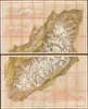
This is Eugène Emmanuel Viollet-le-Duc's stunning chromolithographic 1876 map of Mont Blanc, produced after years of studying the massif's geography and geology. It is considered the greatest map of Mont Blanc ever produced, reflecting Viollet-le-Duc's artistic skills and unique experience as France's premier restorationist of historic sites. The map's production also coincided with territorial disputes between France and Italy (still unresolved) following the 'return' of Mont Blanc to France in 1860.A Closer Look
The map consists of two separate sheets, each measuring 24.75 x 40.5 inches, resulting in a whole measuring 49.5 x 40.5 inches. Coverage embraces the entire massif and its immediate surroundings, including nearby mountain peaks and the towns of Martigny, St. Gervais, and Courmayeur. Aside from villages and hamlets, chalets, roads, paths, and passes are also indicated throughout. Elevation is marked at many points, while mountains and glaciers are labeled. Color is used to differentiate terrain, especially glaciers. Three profile diagrams present the region in longitudinal and cross sections. In producing this map, Viollet-le-Duc drew on the work of military topographers, especially Jean-Joseph Mieulet, while also drawing on his own artistic background to transform the military's topographic maps into high art.'The Mieulet Map'
Viollet-le-Duc was strongly influenced by the 'Mieulet map,' which had been prepared in 1863 by Jean-Joseph Mieulet, who had overseen the topographic surveys at Mont Blanc, and was published in 1865. Mieulet collaborated with the prominent Irish mountaineer Anthony Adams-Reilly to produce what was the most accurate, mathematically rigorous topographical survey of the landscape up to that time, masterfully utilizing contour lines to illustrate the shifting glacial surfaces and popular ascent routes like the Bossons glacier. However, the map also sparked an enduring geopolitical dispute; Mieulet drew the French-Italian international border 'hooking' south of the natural geographic watershed, claiming the summit of Mont Blanc entirely for France. This departure from previous treaties, which divided the peak equally between the two nations, established a cartographic precedent that Italy continues to contest to this day.Wider Historical Context
The 1860 annexation of Savoy by France, formalized through the Treaty of Turin, served as the geopolitical reward promised to Emperor Napoleon III by the Kingdom of Sardinia in exchange for French military assistance during the Second Italian War of Independence. While a heavily managed regional plebiscite overwhelmingly ratified the territorial transfer, the abrupt shifting of alpine borders birthed a protracted diplomatic and cartographic dispute regarding sovereignty over Mont Blanc. The subsequent 1861 demarcation agreements intended to finalize the frontier, but ambiguous wording and conflicting mapping traditions led France to claim that the entire summit of Western Europe's highest peak fell safely within its new borders. In contrast, Italy maintains that the post-annexation boundary bisects the mountain's highest ridge, making the summit a shared national treasure.Chromolithography
Chromolithography, sometimes called oleography, is a color lithographic technique developed in the mid-19th century. The process uses multiple lithographic stones, one for each color, to yield a rich composite effect. Generally, a chromolithograph begins with a black basecoat upon which subsequent colors are layered. Some chromolithographs used 30 or more separate lithographic stones to achieve the desired effect. Chromolithograph color can be blended for even more dramatic results. The process became extremely popular in the late 19th and early 20th centuries when it emerged as the dominant method of color printing. The vivid color chromolithography made it exceptionally effective for advertising and propaganda.Publication History and Census
This map was prepared by Viollet-le-Duc in 1876, drawing on the Mieulet Map, and coincided with the publication of his book Le massif du Mont Blanc: étude sur la constitution géodésique et géologique sur ses transformations et sur l'état ancien et moderne de ses glacies. The map was engraved by Georges Erhard Schièble, printed by Jean Noël Monrocq, and published by J. Baudry. The map is cataloged multiple times in the OCLC, often listed as being printed on four sheets instead of two, though with similar dimensions in either case. In either format, it is held by some 13 institutions worldwide, mostly in Europe, with only the University of California Berkeley, the University of California Los Angeles, the New York Public Library, and Harvard University holding it in the United States.Cartographers
Eugène Emmanuel Viollet-le-Duc (January 27, 1814 - September 17, 1879) was a French architect, restorer of historical sites, and amateur geologist and geographer of Mont Blanc in the Alps. Viollet-le-Duc grew up in a well-connected and intellectually vibrant Parisian household; his father was governor of royal residences under the July Monarchy. A talented artist from a young age, Viollet-le-Duc was interested in historical buildings and their structure, but insisted on learning architecture through self-directed study and extensive travel rather than attending the rigid but well-regarded École des Beaux-Arts. His artistic skill was such that at age 20, he was made an associate professor at the Royal School of Decorative Arts. He traveled widely, producing paintings and drawings, many of which appeared in Voyages pittoresques et romantiques dans l'ancienne France. Viollet-le-Duc also gained practical experience in architecture while working under Achille Leclère, who arranged for him to work on projects for government buildings. In 1840, he was tasked with restoring the Vézelay Abbey, damaged in the Wars of Religion and the French Revolution, a daunting task as there was no plans to work with and very little published information on Medieval architecture at the time. Although he had to modify some elements of the Abbey to ensure stability, Viollet-le-Duc managed to rescue the structure, which likely would have collapsed within a few decades otherwise. His success led to his being brought in to consult on other historical restoration projects, including Sainte-Chapelle in Paris. In 1844, he and Jean-Baptiste Lassus were tasked with restoring Notre-Dame Cathedral, which had also been badly damaged during religious and political strife. Over the following decades, Viollet-le-Duc became the most prominent restorer of Medieval sites in France, working on churches, cathedrals, and castles, along the way becoming a professor at the École des Beaux-Arts. He generally oversaw multiple restoration projects at once as the work took years to complete and his expertise was in high demand, leading to his traveling almost constantly. Always controversial and shunned by most formally trained architects, he championed a bold and controversial restoration philosophy aimed at re-establishing historical buildings into a state of complete structural idealization that may never have actually existed. His influential theoretical writings argued that a building's form must follow its materials and function, a concept of 'structural rationalism' that deeply inspired later masters of modern architecture, including Antoni Gaudí, Louis Sullivan, and Frank Lloyd Wright. In his later years, Viollet-le-Duc harmonized his architectural theories with the natural world, dedicating eight summers between 1868 and 1876 to an obsessive cartographic and geological study of the Mont Blanc massif. Viewing mountains as nature's grandest architecture, he rejected contemporary military maps as inaccurate and painstakingly produced his own highly detailed 1:40,000 scale topographical map using sophisticated shading to render three-dimensional alpine terrain. His resulting 1876 book, Le Massif du Mont Blanc, advanced a unique theory that the mountain was originally formed as a perfectly regulated rhombohedral crystalline system that was being slowly 'ruined' by glacial erosion. By mapping the massif, Viollet-le-Duc sought to mentally 'restore' the mountain to its primordial blueprint, applying the same logic to nature that defined his architectural work. In his later years, Viollet-le-Duc contributed to the design of the Statue of Liberty, the Paris Universal Exposition of 1878, and National Museum of French Monuments. In 1834, he married Elisabeth Tempier, with whom he had two children, but the couple separated after a few years due to Viollet-le-Duc's continuous travels to various restoration sites around France. Further Details...
J. Baudry (fl. c. 1850 - 1914) was a French publisher based in Paris. Baudry was initially (c. 1850) in a partnership with Gide, publishing as Gide et J. Baudry, then (c. 1865) broke out on his own, often publishing as 'Librairie Polytechnique J. Baudry'. Works were published under the J. Baudry name until 1914, with work likely interrupted by World War I (1914 - 1918). In its later years, the firm focused on the publication of the influential, annual work Portefeuille Économique des Machines, de l'Outillage et du Matériel. It is unclear if J. Baudry had any connection with the popular Librairie Européenne Baudry, started c. 1815 by Louis-Claude Baudry. Further Details...
Jean Noël Monrocq (December 25, 1819 - February 18, 1913) was a French printer and bookseller active in Paris in the mid to late 19th century. Monrocq was the son of a farmer, born on Christmas Day, hence his name, in Trelly, La Manche, France. In 1839, he moved to Paris for a more urban lifestyle. Although he had little formal education, he found work with the Parisian book and print seller Delarue. Meeting with success, he opened his own print shop in 1848. He initially applied for a bookseller's patent in 1853, but the application was initially rejected. It was formally approved in 1877. In 1859, he received a lithographer's patent for artistic and industrial prints for educational purposes. He took over the presses of Louis Etienne Stanislas Petit in 1859, but did not receive a formal intaglio imprint until 1865. In March 1874, he established a branch of his lithographic printing press in Ivry, Rue de Vitry, where he moved some of his equipment. He became known for zincographic lithography - the process of etching plates into zinc, which he falsely claimed to have invented. He did, nonetheless, contribute significantly to the industrialization of printing with zinc plates. Being of cheap materials, simple to make, and easy to modify, zinc plates became the standard for news printing. Zincography under Monrocq was also ideally suited to map production, and Monrocq produced a significant corpus of maps, spearheading the movement to centralize map production in France. The firm continued well after Monrocq's death, issuing maps for both Hachette Taride. For a time, his son, Léon Monrocq (1857 - 1902), worked with him, specifically printing maps, but tragically, he died young and did not inherit the business. The firm was taken over by the founder's son-in-law, who took the name Gaillac-Monrocq. Jean Noël Monrocq's grandson, Lucien Monrocq, eventually took over the business. Jean Noël Monrocq is interred in the family crypt at Paris's famous Père Lachaise Cemetery. Further Details...
Georges Erhard Schièble (1823 – November 23, 1880) was a German printer active in Paris during the middle to late 19th century. Erhard was born in Forchheim, Baden-Württemberg, and relocated to Paris in his 16th year, where he apprenticed under his cousin, an engraver and mapmaker. In 1852, after 6 years with the Royal Printing Office, he started his own business. Around this time, he also became a naturalized French citizen. From his offices on Rue Bonaparte, he produced several important maps, and a detailed topography of Gaul for Napoleon III's History of Julius Caesar. In 1865 he took on larger offices expanding his operations to include a lithographic press. He was among the first to introduce printed color maps and pioneered photo-reduction, including the process known as Erhard reproduction. After Erhard's death in 1880, the firm was taken over by his sons and run under the imprint of 'Erhard Frères' until 1911. Further Details...
Condition
Excellent. Slight toning on old fold lines. Folds into original box. Original linen stable.
References
OCLC 21753137 et al.