
1709 / 1726 Herman Moll Map of the World

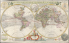
A New and Correct Map of the World Laid Down According to the Newest Discoveries, and from the Most Exact Observations, by Herman Moll Geographer.
Most visually engaging atlas map of the world from the early Colonial period.
- Digital Map Information
- Suitable for large format printing
- Full resolution TIFF file
- ICC color profile embedded
- Delivered instantly via download link
Most visually engaging atlas map of the world from the early Colonial period.
This is Herman Moll's 1707 / 1726, large-format double-hemisphere map of the world. It is the largest and most visually entertaining English atlas map of the world from the early Colonial period; it captures a view of the world in the midst of a transformation from the state of the art of the 17th century to a more scientifically focused style of cartography. The new mode - predominantly French - dominates the map: ironic, given Moll's adopted English chauvinism.A Closer Look
The two-sheet map is dominated by the hemispheres, but is enhanced by the inclusion of an array of subordinate diagrams. At the top center is a north polar projection, showing empty ice seas beyond the Arctic Circle. The top corners contain diagrams of the Solar System after Ptolemy and Copernicus; the latter includes the Great Comet of 1680's track. The bottom corners depict the Sun, Moon, and the planets, following the Cassini model. The bottom center contains an elaborate dedication to King George. The track of Dampier's circumnavigation is noted, and the oceans are annotated with their predominant trade winds and monsoons; it is among the first world maps to do so. The Equinox, Ecliptic, and the Tropics of Cancer and Capricorn are annotated with explanations of their effects; likewise, the poles contain explanations of their seasonal lack of sunlight.The Map of the World
The map presents modern geographical knowledge. In North America, this is exemplified by such details as a reasonably correct delineation of the Great Lakes and a Mississippi after Hennepin, along with one of the greatest cartographic canards of the previous century: a prominent, insular California. Moll also, via the French geographer De l'Isle, includes the apocryphal discoveries of the Baron Lahontan in western Canada, thus blending the errors of several consecutive eras. Moll's delineation of the East Coast extends New England up to the St. Lawrence River, and Labrador is prominently marked as 'New Britain.' As for the Pacific Northwest beyond Lahontan's rivers and north of California, Moll chose to show nothing, cautiously labeling these areas 'Parts Unknown'. On the other side of the Pacific, following the French and Dutch models of the 17th century, Moll depicts Hokkaido (Iesso) as a large peninsula extending from the Asian mainland. The sea between Japan and Korea is here identified as the 'Sea of Corea,' a terminology which is fluid among maps of the region over the centuries, and a bone of contention between the two relevant nations today. With respect to a conflict more personal to Moll, the map includes (in addition to Moll's own delineation of Japan) a sketched Sanson's position of the Japanese islands, some 25° to the east. In the South Pacific, Australia (New Holland) appears as per Abel Tasman, whose 1642 charting of Australia, Tasmania, and New Zealand would not be improved upon until Cook's 1770 voyage.Publication History and Census
This map was engraved for Moll as a separate issue as early as 1707; it would later be included in Moll's folio New and Complete Atlas. Subsequent issues can be dated according to changes in the sellers' imprint. The present example, with the inclusion of John Bowles' imprint and his 'over against Stocks Market' address, is consistent with examples dated 1726. The map, in its varied editions, is reasonably well represented in institutional collections; quality examples are increasingly difficult to find on the market.Cartographer
Herman Moll (1654 - 1732) was an important 18th century map publisher and engraver based in London and Holland. Moll's origins are disputed with some suggesting he was born in the Netherlands and others Germany - the Moll name was common in both countries during this period. Most likely Moll was a German from Bremen, as his will, friends, and contemporaries suggest. What is known for certain is that he moved to London in 1678, possibly fleeing the Scanian War, where he worked as an engraver for Moses Pitt and other London map publishers. Around the turn of the century, Moll set up his own shop where he produced a large corpus of work known for its high quality and decorative flair. As a new émigré to England, Moll made himself more English than the English, and through his cartography proved a fierce advocate for his adopted nation. Most of Moll's early maps were issued as loose sheets that would be bound to order, however, he did publish several important atlases late in his career. Moll is said to have made the bold claim that without a doubt "California is an Island" and that he "had in [his] office mariners who have sailed round it." While California may not be an island (yet), it is true that Moll had talent for attracting interesting friends and acquaintances. He frequented London's first stock exchange, Jonathan's Coffeehouse at Number 20 Exchange Alley, Cornhill. At the time Jonathan's was known as "a place of very considerable concourse for Merchants, sea faring Men and other traders" (Erleigh, The Viscount, The South Sea Bubble, Manchester: Peter Davies, Ltd., 1933, 21). Eventually this activity attracted the interest of stock brokers, who inspired by sailor's tales, sponsored the ill-fated South Sea Company, the world's first stock bubble. Moll's close circle, mostly from the Coffee House, included scientist Robert Hooke, the writers Daniel Defoe (Robinson Crusoe) and Jonathan Swift (Gulliver's Travels), the pirates William Dampier, William Hacke and Woodes Rogers, and the archeologist William Stukeley. Herman Moll's work was highly regarded for its decorative beauty and was pirated, most notably by the Irish publisher George Grierson, both in his lifetime and after his 1732 death at St. Clement Danes, London. Further Details...
Source
Moll, H., The World Described; or a New and Correct Sett of Maps, (London) 1726.
Condition
Very good. Reinforced at folds, else excellent.
References
OCLC 909308077. Rumsey 9729.003.