
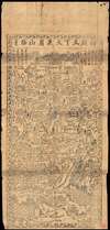
1700 Qing or Ming Dynasty Chinese Map of Mount Emeishan, Sichuan, China

This item has been sold.
[Emeishan] / 峨眉山.
The Sacred Mountain Emei Shan.
Choose a Collection:
- Digital Map Information
- Suitable for large format printing
- DPI: 300
- File Size: 31.79 MB
- File Type: ZIP / TIFF
- ICC color profile embedded
- Delivered instantly via download link
This Item
Enquire
The Sacred Mountain Emei Shan.
An extraordinary find. This is a fragile early 17th or 18th century early Qing Dynasty Chinese xylograph (woodblock) map of Mount Emei or Mount Emeishan. Emishan is one of Four Sacred Buddhist Mountains in China. It is located at the western rim of the Sichuan Basin. The mountain is known for its 76 Buddhist monasteries of the Ming and Qing period. Maps such as this were issued as souvenirs or guides to pilgrims ascending to the sacred summits. Chinese maps of this era are extremely rare in private hands and almost never appear on the market.Condition
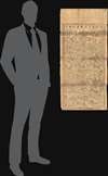
Average. Map could do with restoration but due to its extraordinary rarity, we have left it as is. Minor rips and tears here and there. Edges tattered, as seen. Older Chinese repairs on verso. Overall toning.