
1709 Elizabeth Verseyl Visscher Map of Russia (Muscovy)


This item has been sold.
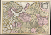
Nouvelle Carte Geographique du Grand Royaume de Moscovie Representant la Partie Septentrionale etc. Par Nicolas Visscher a Amsteldam avec Privilege des Etats Generaux.
State of the Art of Mapping Peter's Russia.
- Digital Map Information
- Suitable for large format printing
- Full resolution TIFF file
- ICC color profile embedded
- Delivered instantly via download link
State of the Art of Mapping Peter's Russia.
This is a striking old color example of Elizabeth Verseyl Visscher's scarce c. 1709 map of Russia. Though bearing the imprint of Nicholas Visscher II (1649 - 1702), it was updated and issued by his widow, Verseyl Visscher, who managed the firm until her 1726 death. Under her guidance and in collaboration with Peter the Great's geographers, this, the most up-to-date map of the Russian Empire, was added to the Visscher oeuvre.A Closer Look
This large, beautiful map spans from as far east as the Pechora River (in the north) and Sarapul on the Kama River in the south. It reaches as far west as the Gulf of Finland, showing the parts of Sweden now considered to be Finland. Part of Estonia appears as well. St. Petersburg, founded in 1703, is marked and named. Although covering roughly the same regions as the Dutch maps derived from Isaac Massa and Hessel Gerritsz in the previous century, the detail here far surpasses anything available in the 17th century. The Dvina River and its tributaries appear in particularly fine detail.A State-of-the-Art Work
Following Nicolaes' death in 1702, his widow Elizabeth continued to build on her husband's atlas, drawing on the most current cartographers to do so. In this case, the source was the French geographer, Guillaume De l’Isle. His 1706 Carte de Moscovie was the best selection Verseyl Visscher could have made. De l'Isle's map was produced with the cooperation of Andrey Artamonovich Matveyev, Peter the Great’s ambassador in Western Europe: De l'Isle was here anticipating his family's long tradition of mining Russian cartography for new information. This is confirmed by the unusually well-detailed revisions of the region's river systems (very different from earlier Dutch models), better placement and more accurate naming of towns, the addition of strategic routes, and other details relevant to Peter the Great's attempts to administer a growing empire.De l'Isle's mapping would inform many more maps of the first half of the 18th century, including works by Ottens, Senex, and Chatelain. But Verseyl Visscher's version appears to have been the first, published as early as 1706. We see examples of the second, Schenk state of this map cataloged with the date of 1715, but these are probably best dated to 1726, the date Schenk acquired most of the Visscher plates and stock.
Publication History and Census
This map was engraved as early as 1706 but probably no later than 1709 for inclusion in Elizabeth Verseyl Visscher's Atlas Minor. It appears more frequently in the second state, with Peter Schenk's imprint. We see a dozen examples cataloged in institutional collections, exhibiting an astonishing imprecision in dating.Cartographers
Elizabeth Verseyl Visscher (16?? - 1726) was a Dutch atlas publisher. It is not known when she was born, and nothing is known of her education. On December 10, 1680, she married mapmaker Nicolaes Visscher II (1649 – May 31, 1702). When Nicolaes died, Elizabeth ran the business, both continuing to publish Nicolaes' maps and adding to the company's oeuvre until 1726, at which point the stock of copperplates was sold to Peter Schenk. (It is not known whether the sale preceded her death, or was posthumous.)
We are not aware of any instance of Verseyl Visscher's name appearing on a map; rather she is identified as 'Widow of Nicolaes Visscher.'
Further Details...
Guillaume De l’Isle (1675 - 1726) was a French cartographer, and arguably the finest mapmaker at the beginning of the eighteenth century. He was the son of Claude De L'Isle (1644 -1720), a Paris-based historian and geographer under Nicholas Sanson, then the leading light of French cartography. He was the chief proponent of the school of 'positive geography' and the primary figure defining the heights of the Golden Age of French Cartography. Guillaume's skill as a cartographer was so prodigious that he drew his first map at just nine years of age. He was tutored by J. D. Cassini in astronomy, science, mathematics and cartography. By applying these diverse disciplines to the vast stores of information provided by 18th century navigators, Guillaume created the technique that came to be known as 'scientific cartography', essentially an extension of Sanson's 'positive geography'. This revolutionary approach transformed the field of cartography and created a more accurate picture of the world. Among Guillaume's many firsts are the first naming of Texas, the first correct map of the Mississippi, the final rejection of the insular California fallacy, and the first identification of the correct longitudes of America. Stylistically De L'Isle also initiated important changes to the medium, eschewing the flamboyant Dutch style of the previous century in favor of a highly detailed yet still decorative approach that yielded map both beautiful and informative. Guillaume was elected to the French Academie Royale des Sciences at 27. Later, in 1718, he was also appointed 'Premier Geographe du Roi', an office created especially for him. De L'Isle personally financed the publication of most of his maps, hoping to make heavy royalties on their sales. Unfortunately he met an untimely death in 1728, leaving considerable debt and an impoverished child and widow. De L'Isle's publishing firm was taken over by his assistant, Phillipe Buache, who would also become his son in law. Further Details...
Source
Versyl Visscher, Elizabeth, Atlas Minor sive Geographia Compendiosa, (Amsterdam: Visscher) 1706-1714.
Condition
Very good. Some cracking in areas of oxidation with very slight loss. Original wash color.
References
OCLC 936200435.