This item has been sold, but you can get on the Waitlist to be notified if another example becomes available, or purchase a digital scan.
1794 Carey / Lewis Map of New Hampshire
NewHampshire-carey-1794$700.00

Title
The state of New Hampshire, compared chiefly from actual surveys.
1794 (dated) 17.5 x 11.25 in (44.45 x 28.575 cm) 1 : 696960
1794 (dated) 17.5 x 11.25 in (44.45 x 28.575 cm) 1 : 696960
Description
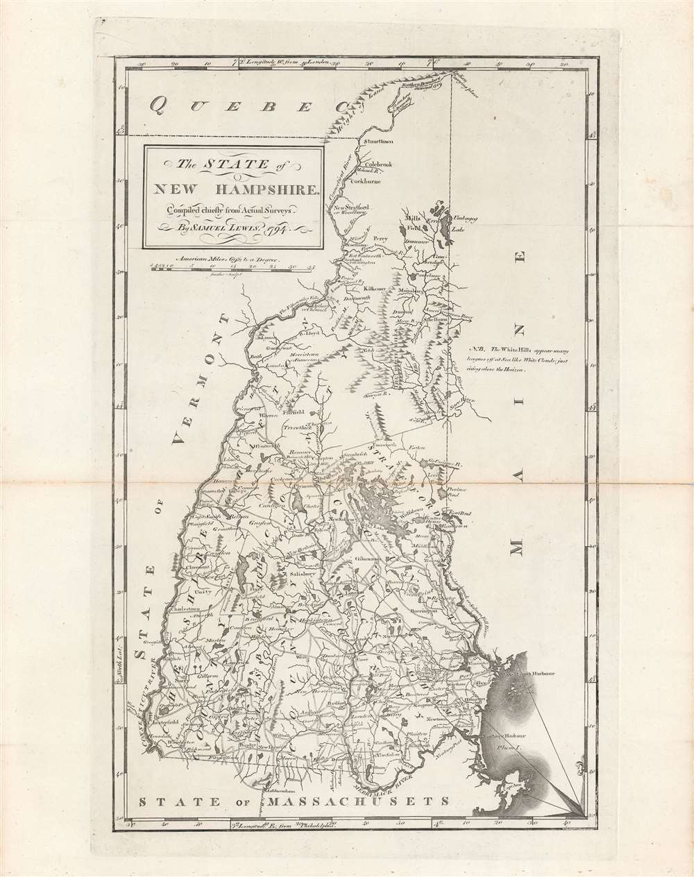
This is Samuel Lewis' 1794 map of New Hampshire, which appeared in Carey's General Atlas, the first atlas produced and published in the United States. It provides a wonderful snapshot of the state in the early days of the American Republic.
Not only would the 'White Hills' soon afterwards become known as the 'White Mountains,' but more than a dozen peaks would be renamed after American presidents and other prominent public figures, lending the title 'Presidential Range' to the tallest of the White Mountains. The origins of this practice are somewhat unclear, as Mount Washington was known at the time of this map's production as 'the highest mountain,' 'the great mountain,' and by several other names, in addition to its names in Native American languages. It is believed that the name 'Mount Washington' resulted from its being so-named by the Belknap-Cutler Expedition, an early ascent of the mountain in 1784, and was gradually adopted in the closing years of the 18th century. Most of the other mountains in the range were renamed in the early decades of the republic, but in 1969, Mount Pleasant was changed to Mount Eisenhower.
Many towns identified here retain their names, while others changed their name due to disputes over incorporation, as was the case with Franconia also being known as Morristown. The town of Dartmouth towards top-center became Jefferson in 1796 when the town incorporated. It later expanded to include a portion of neighboring Kilkenny, which now is an unpopulated township within the White Mountain National Forrest.
The dotted lines indicate borders between counties. At the time, there were only five counties in the state (Cheshire, Grafton, Hillsborough, Rockingham, and Stratford), which eventually expanded to ten. The northern part of the state, composed entirely of Grafton County here, was generally considered undesirable given its remoteness, harsh winters, and the threat of hostilities with Native Americans who had sided with the French in the French and Indian War.
Also worth noting is the presence of Dartmouth College, indicated separately from the town of Hanover. The college was founded in 1769 by Eleazar Wheelock to train Native Americans as Christian missionaries, but quickly deviated from this focus. In order to support the college's finances, the state provided it 42,000 acres in far northern New Hampshire, noted here, now the town of Clarksville.
A Closer Look
Roads, rivers, and mountains to settlements and important sites are indicated. The geography of the state is immediately recognizable, but there are notable differences with maps of New Hampshire produced even a few decades later. Most obviously, as referred to in a note at right, the White Mountains are labeled 'White Hills,' which 'appear many leagues off at Sea like white clouds: just rising above the Horizon'.Not only would the 'White Hills' soon afterwards become known as the 'White Mountains,' but more than a dozen peaks would be renamed after American presidents and other prominent public figures, lending the title 'Presidential Range' to the tallest of the White Mountains. The origins of this practice are somewhat unclear, as Mount Washington was known at the time of this map's production as 'the highest mountain,' 'the great mountain,' and by several other names, in addition to its names in Native American languages. It is believed that the name 'Mount Washington' resulted from its being so-named by the Belknap-Cutler Expedition, an early ascent of the mountain in 1784, and was gradually adopted in the closing years of the 18th century. Most of the other mountains in the range were renamed in the early decades of the republic, but in 1969, Mount Pleasant was changed to Mount Eisenhower.
Many towns identified here retain their names, while others changed their name due to disputes over incorporation, as was the case with Franconia also being known as Morristown. The town of Dartmouth towards top-center became Jefferson in 1796 when the town incorporated. It later expanded to include a portion of neighboring Kilkenny, which now is an unpopulated township within the White Mountain National Forrest.
The dotted lines indicate borders between counties. At the time, there were only five counties in the state (Cheshire, Grafton, Hillsborough, Rockingham, and Stratford), which eventually expanded to ten. The northern part of the state, composed entirely of Grafton County here, was generally considered undesirable given its remoteness, harsh winters, and the threat of hostilities with Native Americans who had sided with the French in the French and Indian War.
Also worth noting is the presence of Dartmouth College, indicated separately from the town of Hanover. The college was founded in 1769 by Eleazar Wheelock to train Native Americans as Christian missionaries, but quickly deviated from this focus. In order to support the college's finances, the state provided it 42,000 acres in far northern New Hampshire, noted here, now the town of Clarksville.
Revolutionary War References
Piscataqua Harbour, towards bottom right, was the site of an important event in the opening days of the Revolutionary War, when Fort William and Mary, the only British garrison in New Hampshire, guarded by all of six troops, was overrun by patriots, who seized weapons and ammunition for the revolutionary cause.Publication History and Census
This map was made Samuel Lewis in 1794 and engraved by James Smither for the first (1795) edition of Carey's General Atlas (sometimes subtitled American Edition of Guthrie's Geography improved). The prevalence of the map is difficult to determine since it is sometimes cataloged independently and sometimes with the atlas, and because the various early printings of Carey's atlas have led to it being dated anywhere from 1794 - 1796. The map looks to be independently cataloged in the holdings of perhaps a dozen universities and research institutions in the United States and Europe, while the entire atlas is somewhat more widely distributed.CartographerS
Matthew Carey (January 28, 1760 - September 16, 1839) was a Dublin born publisher who established himself in Philadelphia in the late 18th and early 19th century. A young man of socially progressive views, Carey's first known publication, produced when he was but 17 years old, was a pamphlet criticizing dueling. Another pamphlet, issued in the same year, attacked the Irish penal code. Shortly afterwards, in 1779, legal issues, possibly arising from his liberal political activism, forced Carey to flee to Paris. In Paris, Carey had the good fortune to befriend the visiting American diplomat and founding father, Benjamin Franklin (1706 - 1790). As an Irishman chafing under the rule of England, Carey sympathized with and admired the American revolutionary. The liberally minded pair struck up a lifelong friendship and Carey was hired to work at Franklin's press in Passy, France. A year later, Carey returned to Ireland and resumed his politically provocative publishing career with The Freemans's Journal and The Volunteer's Journal. It didn't take long for political pressure to once again force Carey from Ireland - this time to America (1784). Although largely without funds, Carey convinced Gilbert du Motier, Marquis de Lafayette (1757 - 1834), who he knew from Franklin's Paris circle, to lend him funds to establish a new publishing concern in Philadelphia. Despite this loan, Carey's firm remained under financed and opened on a shoestring budget. It was most likely his limited budget that led Carey to some of his most important publishing innovations. At the time cartographic publishing was dominated by large printing houses in London and Paris where most, if not all, of the work was completed in house. Without the finances to emulate this large publishing houses, Carey was forced to outsource much of his publishing work. This set the stage for subsequent American publishers who, in order to compete effectively with European firms, relied on an often bewildering network of alliances and collaborations. Carey was also a master of republishing many of his own maps in multiple different atlases and formats to maximize their profitability. His most important work is without a doubt the 1795 issue of the American Atlas the first atlas to be published in America. Carey died in 1839 but was succeeded by his son Henry Charles Carey (1793 - 1879) who, in partnership with his brother-in-law Isaac Lea (1792 - 1886), published numerous important maps and atlases under the Carey and Lea, Lea Brothers, and Lea and Blanchard imprints. More by this mapmaker...
Samuel Lewis (c. 1754 - 1822) was an American engraver, cartographer, draftsman, and geographer active in Philadelphia in the first of the 19th century. Though is place of birth is uncertain, most agree that Lewis emigrated from Dublin, Ireland, in the late 18th century. Lewis' earliest cartography work was produced in partnership with the well-known Philadelphia publishers Matthew Carey and Henry Schenk Tanner. In 1804, with the intention of republishing high quality English maps in the United States, Lewis partnered with the eminent British map publisher Arron Arrowsmith. Their first joint publication was A New and Elegant General Atlas, but many others followed including an American edition of Arrowsmith's important double hemisphere wall map of the world. Arrowsmith also worked with Jedidiah Morse, among other important American cartographers of the period. Ralph Brown considers Lewis to be "the most enterprising commercial map-maker of the period … " Lewis is best known for his map related to the expedition of Meriwether Lewis (no relation) and William Clark. In 1814 Lewis, copying directly from William Clark's manuscript, issued A Map of Lewis and Clark's Tracks across the Western Portion of North America. This important document was the first published map derived from the Lewis and Clark Expedition and profoundly transformed the cartography of the American northwest. Samuel Lewis of Philadelphia should not be confused with Samuel Lewis of London, another cartographer active during roughly the same period. Learn More...
William Guthrie (1708 - March 9, 1770) was a Scottish historian, journalist, and writer. Born in Brechin, he studied at Aberdeen University with the idea of becoming a parochial schoolmaster. Instead, in 1730, he elected to settle in London and try his hand at literature. He covered parliamentary debates f or the Gentleman's Magazine and soon earned a reputation for being a political writer. He published several scholarly works, including a History of England from the Invasion of Julius Caesar to 1688 in four volumes, and, most notably, his Geographical Historical, and Commercial Grammar. Learn More...
Source
Carey, M., Carey's General Atlas, (Philadelphia: Carey) 1795.
Condition
Very good. Strong impression. Original platemark visible. Some discoloration reinforcement along centerfold.
References
Rumsey 2931.027. OCLC 5565264, 950941620.