
1939 Richard Edes Harrison Map of New York City (Inscribed by the author)




This item has been sold.
The City of New York.
Brilliant, data rich depiction of mid-century New York.
- Digital Map Information
- Suitable for large format printing
- Full resolution TIFF file
- ICC color profile embedded
- Delivered instantly via download link
Brilliant, data rich depiction of mid-century New York.
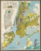
This is an inscribed example of Richard Edes Harrison's 1939 map of New York City. Published in conjunction with the New York World’s Fair, his work represents a triumph of the visual display of quantitative information. Its aesthetic impact is all the more impressive in its clear expression of municipal and demographic data, making this a map of the people of New York City, as much as of the physical city itself. All five boroughs are represented in the primary map. On it, Harrison’s masterful use of vivid color to distinguish between residential, commercial, industrial, and federal use of land is clear yet supple, able to make distinction (for example) of low-income housing projects using the same palette. Parks and cemeteries both appear as green spaces, with white spots - evoking headstones - indicating the difference between the two. The two major airports (Floyd Bennett Field and North Beach Airport) are given their own color as well. The city’s industrial areas, shown in black, dominate the East River and Hudson coastlines, a reminder of the city’s past as a factory and shipping center.The Lower Half of Manhattan in Detail
Underneath the map’s title, a detail of Manhattan from the middle of Central Park to The Battery allows for the presentation, in finer detail, of New York’s finer life: Using a new color code, Harrison marks the city’s most valuable real estate (structures assessed at 5 million dollars or more!) These include business buildings, stores, apartment houses, theatres… and ‘other theatres.’ (The precise nature of that last distinction is not made clear.)This detail map also includes the termini of lower Manhattan's bridges and tunnels - including Gustav Lindenthal's monolithic, proposed, and ultimately unbuilt Hudson River Bridge. The plans, drawn up in 1921, would have had a massive span across the Hudson - nearly twice the length of the Brooklyn Bridge - starting at 57th street. The construction of the Holland and Lincoln tunnels stymied the construction of the bridge. Harrison sneaks in a puckish joke here: 'Proposed Lindenthal Bridge: under obstruction'. On this example, In addition to Harrison's inscription, he has added an arrow pointing out the absent bridge, with the annotation 'NB' (Nota Bene, that is, 'carefully observe.') Harrison was drawing attention to his joke that, as published, may have been more subtle than he would have preferred.
Day And Night
Though smaller and perhaps more abstract, the detail in the. lower right-hand corner of the map matches the rest of it in fascination: a dual map of all five boroughs in miniature, using bright and dark palettes to show the changing population density of the city by day and by night. Never was the diurnal chaos of the New York City commute presented so cleanly.In an old-world touch, the map sports a very elegant compass rose. But even this is packed full of useful detail: within its circuit is yet another inset map, showing the ‘limit of the main map’ in the context of the greater metropolitan area and the surrounding states.
Publication History and Census
This map appeared in only one edition, as a supplement to the July issue of Fortune Magazine. OCLC lists eight examples in institutional collections.Cartographer
Richard Edes Harrison (March 11, 1901 - January 5, 1994) was an American cartographer, scientific illustrator, and designer based in New York City, active principally from the 1930s through the 1970s. His journalistic maps combined unconventional viewpoints, expressive relief shading, and carefully controlled graphic design to explain international geography to a broad readership. Born in Baltimore, Maryland, and raised in New Haven, Connecticut, he graduated from Yale College in 1923 with a major in zoology and a minor in chemistry. After working as a scientific illustrator and architectural draftsman, he entered Yale's School of Fine Arts in 1926 and received an architecture degree in 1930. With architectural work scarce during the Depression, he moved to New York and worked in interior and industrial design. A 1932 Time map assignment launched his career in magazine cartography; he later became a staff cartographer for Fortune before returning to freelance work in 1938, maintaining important associations with Fortune and Life. During World War II, Harrison challenged the familiar north-up, Mercator-centered view of world affairs through polar projections, orthographic views, and oblique perspectives that emphasized the Earth's curvature and the proximity of continents in an age of aviation. His Three Approaches to the U.S. (1940) and The World Divided (1941) made American strategic vulnerability visually immediate, supporting an internationalist understanding of the conflict rather than geographical isolation. His influential Look at the World: The Fortune Atlas for World Strategy appeared in 1944. Although admired for their explanatory power, his departures from conventional orientation, scale, and projection also attracted criticism from professional geographers and cartographers. Harrison taught at Syracuse University from 1945 to 1949 and consulted for government agencies, including the Office of Strategic Services, the State Department, and the U.S. Geological Survey. His later publications included The Ginn World Atlas (1963), and he contributed shaded-relief cartography to The National Atlas of the United States of America. He received the American Geographical Society's Miller Medal in 1968. An enthusiastic birdwatcher with a sustained interest in Central Park conservation, Harrison died in New York City on January 5, 1994; the Library of Congress acquired his professional and personal papers in 1995. Further Details...
Condition
Excellent. Margins complete though close as always. Virtually devoid of usual toning. Inscribed by author, upper left.
References
Rumsey 11077.000. OCLC 35173087.