
1885 Antonio Vallardi Bird's Eye View of the Nile River from the Delta to Khartoum

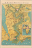
Il Nilo dal Mediterraneo al Sudan.
Italian public interest in the British Nile Expedition (1884 - 1885).
- Digital Map Information
- Suitable for large format printing
- Full resolution TIFF file
- ICC color profile embedded
- Delivered instantly via download link
Italian public interest in the British Nile Expedition (1884 - 1885).
An exceptional c. 1885 chromolithograph bird's-eye view of the Nile River, extending from the Mediterranean Sea and Nile Delta to Khartoum at the confluence of the White and Blue Nile. Published in Milan by Antonio Vallardi, the map was produced to illustrate the British Nile Expedition (1884 - 1885) undertaken to relieve General Charles 'Chinese' Gordon during the Mahdist War (1881 - 1899). It moreover captures northeastern Africa at the height of Khedive Isma'il Pasha's (1830 - 1895) modernizing campaign and imperial ambitions. Isma'il leveraged Egypt's shared ambitions with the emergent Kingdom of Italy to harness Italian engineering, military, and commercial expertise, fueling popular Italian interest in Egypt and inspiring works such as this remarkable view.A Closer Look
Oriented toward the south, coverage embraces from Abyssinia and Sudan to the Mediterranean and from the Sinai Peninsula (including Mt. Sinai) to the desert west of the Nile. The Nile Delta and the Mediterranean occupy the foreground, with Alexandria and its lighthouse on the right and Cairo near the center. The Suez Canal, Port Said, and Suez appear on the left. Giza, the Pyramids, and the Great Sphinx are to the right of Cairo. The region's railroad network is illustrated and connects Cairo with Alexandria, Suez, and Damietta. The railroad network extends south along the Nile to Asyut (Assiout), and steamers are illustrated heading upriver from Cairo. As one travels further up the Nile, towns and villages are illustrated and labeled on both banks, along with monuments and ruins. River hazards, such as cataracts and islands, are marked. Near the top, Khartoum appears at the confluence of the Blue and White Nile. Four insets are included along the right border. The first three detail Khartoum, Massawa, and Suakin; the fourth highlights the African colonial claims of various European powers.Charles Gorden, Kartoum, and the Madhist War
The Mahdist War (1881 - 1899) began as a Sudanese religious and nationalist revolt against Egyptian rule and growing European influence. Under the ambitious Khedive Isma'il Pasha (r. 1863 - 1879), Egypt expanded deep into the Sudan, annexing vast territories along the Nile while imposing heavy taxation, centralized administration, and conducting campaigns against the slave trade, which disrupted longstanding economic and political structures. In 1881, the religious leader Muhammad Ahmad proclaimed himself the Mahdi, or 'Guided One,' uniting tribes and disaffected communities in a jihad against Egyptian authority. After the destruction of a large Egyptian army in 1883, Britain, which exercised increasing influence over Egypt following Isma'il's deposition, decided to abandon the Sudan rather than undertake a costly military campaign.In 1884, General Charles George Gordon was dispatched to Khartoum to organize the evacuation of the remaining Egyptian garrisons. Instead, he chose to defend the city, believing its abandonment would condemn thousands of civilians and soldiers to massacre. The resulting Siege of Khartoum lasted nearly a year and transformed Gordon into one of Britain's greatest imperial heroes. Mounting public outrage eventually compelled the government to dispatch the Nile Expedition under General Sir Garnet Wolseley. Advancing by both the Nile and the Bayuda Desert, the relief force won hard-fought victories at Abu Klea and Kirbekan, but progress proved too slow. Khartoum fell to the Mahdists on January 26, 1885, Gordon was tragically killed, and the expedition reached the city just two days later - too late to save either Gordon or the garrison.
Egypt and Italy Share Imperial Ambitions
The years 1873-75 marked the height of Khedive Isma'il Pasha's imperial ambitions in northeastern Africa. Determined to transform Egypt into a technologically advanced European-style power, Isma'il envisioned an African empire stretching deep into the continent's heart. From Khartoum, Egyptian forces pushed southwards into Equatoria and the Upper Nile, and west into Darfur and Bahr el Ghazal. With the Kingdom of Italy as Egypt's closest western partner, Isma'il recruited Italian engineers, architects, military officers, physicians, and merchants to modernize his infrastructure and military. Italian communities emerged and flourished in Alexandria, Cairo, and Khartoum. Italy itself, beginning to pursue a colonial empire in East Africa, leveraged Egypt as both an ally and a gateway to the continent's interior. Although Isma'il portrayed his ambition as an anti-slavery civilizing mission, it was equally a strategic and economic power play. The enormous costs of the Khedive's military campaigns and modernization projects ultimately plunged Egypt into financial crisis, inviting European intervention and, within a decade, fueling the Mahdist Revolt.Chromolithography
Chromolithography, sometimes called oleography, is a color lithographic technique developed in the mid-19th century. The process involved using multiple lithographic stones, one for each color, to yield a rich composite effect. Often, the process would start with a black base coat, on which subsequent colors were layered. Some chromolithographs used 30 or more separate lithographic stones to achieve the desired product. Chromolithograph color could also be effectively blended for even more dramatic results. The process became extremely popular in the late 19th and early 20th centuries when it emerged as the dominant method of color printing. The vivid color produced by chromolithography made it exceptionally effective for advertising and propaganda imagery.Publication History and Census
This map was created and published by Antonio Vallardi Editore in Milan around 1885, when in terest in the Madhist War was at an all time high. Based upon the state of the railroads as presented, there may be an earlier edition c. 1874, but we cannot verify this. We note a single example cataloged in OCLC, located at the Library of Congress.Cartographer
Antonio Vallardi (1813 - 1876) was an Italian publisher and founder of the Antonio Vallardi publishing house. Born into a Milanese publishing family, his grandfather Cesare Vallardi (1736 - 1799) began publishing books in Contrada Santa Margherita in the 1750s. Vallardi's father, Pietro (1770 - 1819), and uncle Giuseppe (1784 - 1861) continued their father's publishing business but renamed the company Fratelli Vallardi and became prominent publishers of books and art prints. Pietro's sons, Franceso and Antonio, both founded their own publishing houses. Antonio Vallardi opened his publishing house in 1843, three years after his brother. Antonio's publishing house became known for academic and linguistic works, alongside the many maps and guides it published for the Touring Club. Antonio's descendants operated the publishing house until 1970, when they sold the firm to Garzanti. Further Details...
Condition
Good. Light wear along original fold lines. Small areas of loss at some fold intersections. Verso repairs to fold separations. Slight scuffing where previously attached to binder. Accompanied by original binder.
References
OCLC 1315577196.