This item has been sold, but you can get on the Waitlist to be notified if another example becomes available, or purchase a digital scan.
1772 Vaugondy - Diderot Map of Alaska, the Pacific Northwest and the Northwest Passage
NouvellesDecouvertes-vaugondy-1772$200.00

Title
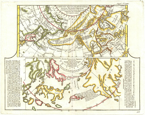
Carte Des Nouvelles Decouvertes dressee par Phil. Bauche Pr. Geograp? Du Roi presentee a l'Adad? Des Sciences le g Aout 1762 et approuvee dans son assemblee du 6 Septembre suivant. / Extrait d'une Carte Japonoise de L'Univers apportee en Europe par Kaempser et deposee dans le cabinet de seu Mr. Han-Sloane president de la Soceity Royale de Londres.
1772 (undated) 12.5 x 15.5 in (31.75 x 39.37 cm)
1772 (undated) 12.5 x 15.5 in (31.75 x 39.37 cm)
Description
This is a fascinating combination of two contrasting maps on a single sheet. Both maps cover the northeastern parts of Asia and the northwestern parts of North America. This two map chart was originally drawn by Phillip Buache to expound upon his theories regarding the northwest coast of America and more specifically upon the possibility of a Northwest Passage.
The upper map, entitled 'Carte des Nouvelles Decouvertes' is a combination of data absconded from the Russian 'Academy of Sciences' and Buache's speculations on the Northwest Passage. When Joseph-Nicholas de L'Isle, younger brother of the better known Guilleme de L'Isle, returned from his tenure at Russian Tzar Peter the Great's 'Academy of Sciences' he decided to publish a compilation of secret cartographic data obtained from previously unknown Russian expeditions to Kamtschaka and the coast of Siberia. These seminal explorations included the discoveries of Tchirikow, Frondat, Bering, among others. De L'Isle produced a ground breaking and largely accurate mapping of the peninsula of Kamchatka and the coast of northeast Asia - shown here.
De L'Isle contracted Buache, already a prominent cartographic figure due to his introduction of hachures as a method for displaying elevation on a two dimensional plane, to complete the North American part of the map. Buache used the mythical voyages of Admiral de Fonte and Juan de Fuca as his cartographic source material. The two sides of this map therefore could not be more heavily contrasted, for the mapping of Asia is largely accurate where the mapping of North America is almost entirely fantastical. This map shows the 'Sea of the West,' supposedly discovered by Fuca, as well as the series of lakes, rivers, and canals heading eastward toward the Baffin and Hudson Bays that were purportedly first identified by De Fonte. These include Lac de Fonte, Lac Belle and Lac de Valasco. The Aleutian Islands are drawn, based upon various recorded land sightings by Russian explorers in the early 18th century, as a single peninsular land mass. This map also traces the voyages of Kamtchatka, St. Antoine and unnamed Russian explorers. Buache and De L'Isle presented this map to the French Academy of Sciences in 1762.
The lower map is a supposed recreation of an early Japanese Map discovered by Englebert Kaempfer and presented to Hans Sloane, President of the Royal Society of London. Kaempher was a German traveler who spent two years in Japan attached to the Dutch Embassy. When he returned to Europe he carried with him numerous documents including an earlier state of the bottom map on this sheet. Displays Asia crudely with only Japan, many times its actual size, displayed with any relative accuracy. This map does however include the Great Wall of China and Baja California – drawn with the hint of a Northwest Passage.
To the left of the lower map is an extract from the Journals of Kaempfer describing Japan and its knowledge of America. To the right side of the lower map is an advertisement claiming the source of this map to be a wall map in the Emperor's palace in Japan.
This map is part of the 10 map series prepared by Vaugondy for the Supplement to Diderot's Encyclopédie, of which this is plate 6. This seminal map series, exploring the mapping of North American and specifically the Northwest Passage was one of the first studies in comparative cartography.
CartographerS
Robert de Vaugondy (fl. c. 1716 - 1786) was French may publishing from run by brothers Gilles (1688 - 1766) and Didier (c. 1723 - 1786) Robert de Vaugondy. They were map publishers, engravers, and cartographers active in Paris during the mid-18th century. The father and son team were the inheritors to the important Nicolas Sanson (1600 - 1667) cartographic firm whose stock supplied much of their initial material. Graduating from Sanson's maps, Gilles, and more particularly Didier, began to produce their own substantial corpus. The Vaugondys were well-respected for the detail and accuracy of their maps, for which they capitalized on the resources of 18th-century Paris to compile the most accurate and fantasy-free maps possible. The Vaugondys compiled each map based on their own geographic knowledge, scholarly research, journals of contemporary explorers and missionaries, and direct astronomical observation. Moreover, unlike many cartographers of this period, they took pains to reference their sources. Nevertheless, even in 18th-century Paris, geographical knowledge was limited - especially regarding those unexplored portions of the world, including the poles, the Pacific Northwest of America, and the interiors of Africa, Australia, and South America. In these areas, the Vaugondys, like their rivals De L'Isle and Buache, must be considered speculative or positivist geographers. Speculative geography was a genre of mapmaking that evolved in Europe, particularly Paris, in the middle to late 18th century. Cartographers in this genre would fill in unknown lands with theories based on their knowledge of cartography, personal geographical theories, and often dubious primary source material gathered by explorers. This approach, which attempted to use the known to validate the unknown, naturally engendered rivalries. Vaugondy's feuds with other cartographers, most specifically Phillipe Buache, resulted in numerous conflicting papers presented before the Academie des Sciences, of which both were members. The era of speculative cartography effectively ended with the late 18th-century explorations of Captain Cook, Jean Francois de Galaup de La Perouse, and George Vancouver. After Didier died, his maps were acquired by Jean-Baptiste Fortin, who in 1787 sold them to Charles-François Delamarche (1740 - 1817). While Delamarche prospered from the Vaugondy maps, he defrauded Vaugondy's window Marie Louise Rosalie Dangy of her rightful inheritance and may even have killed her. More by this mapmaker...
Denis Diderot (October 5, 1713 - July 31, 1784) was a French Enlightenment era philosopher, publisher and writer. Diderot was born in the city of Langres, France and educated at the Lycée Louis le Grand where, in 1732, he earned a master of arts degree in philosophy. Diderot briefly considered careers in the clergy and in law, but in the end chose the more fiscally challenge course of a writer. Though well respected in philosophical circles Diderot was unable to obtain any of the government commissions that commonly supported his set and consequently spent much of his life in deep poverty. He is best known for his role in editing and producing the Encyclopédie . The Encyclopédie was one of the most revolutionary and impressive works of its time. Initially commissioned as a translation of Ephraim Chambers' Cyclopaedia, or Universal Dictionary of Arts and Sciences, Diderot instead turned into a much larger and entirely new work of monumental depth and scope. Diderot's Encyclopédie was intended to lay bare before the common man the intellectual mysteries of science, art and philosophy. This revolutionary mission was strongly opposed by the powers of the time who considered a learned middle class it a threat to their authority. In the course of the Encyclopédie production Diderot was imprisoned twice and the work itself was officially banned. Nonetheless, publication continued in response to a demand exceeding 4000 subscribers. The Encyclopédie was finally published in 1772 in 27 volumes. Following the publication of the Encyclopédie Diderot grew in fame but not in wealth. When the time came to dower his only surviving daughter, Angelique, Diderot could find no recourse save to sell his treasured library. In a move of largess, Catherine the II Russia sent an emissary to purchased the entire library on the condition that Diderot retain it in his possession and act as her "librarian" until she required it. When Diderot died of gastro-intestinal problems 1784, his heirs promptly sent his vast library to Catherine II who had it deposited at the Russian National Library, where it resides to this day. Learn More...
Phillipe Buache (February 7, 1700 - January 24, 1773) was a late 18th century French cartographer and map publisher. Buache began his cartographic career as the workshop assistant and apprentice to the important and prolific cartographer Guillaume de L'Isle. Upon De L'Isle's untimely death, Buache took over the publishing firm cementing the relationship by marrying De L'Isle's daughter. Over the years, Bauche republished many of De L'Isle's maps and charts. Buache was eventually appointed Premier Geographe du Roi, a position created-for and previously held by Guillaume de L'Isle. Buache is most respected for his introduction of hachuring as a method from displaying underwater elevation on a two dimensional map surface. Buache compiled maps based upon geographic knowledge, scholarly research, the journals of contemporary explorers and missionaries, and direct astronomical observation. Nevertheless, even in 18th century Paris geographical knowledge was severely limited - especially regarding those unexplored portions of the world, including the poles, the Pacific northwest of America, and the interior of Africa and South America. In these areas the Buache, like his primary rival Robert de Vaugondy, must be considered a speculative geographer or 'positive geographer'. Speculative geography was a genre of mapmaking that evolved in Europe, particularly Paris, in the middle to late 18th century. Cartographers in this genre would fill in unknown areas on their maps with speculations based upon their vast knowledge of cartography, personal geographical theories, and often dubious primary source material gathered by explorers and navigators. This approach, which attempted to use the known to validate the unknown, naturally engendered many rivalries. Buache's feuds with other cartographers, most specifically Didier Robert De Vaugondy, resulted in numerous conflicting papers being presented before the Academie des Sciences, of which both were members. The era of speculatively cartography effectively ended with the late 18th century explorations of Captain Cook, Jean Francois de Galaup de La Perouse, and George Vancouver. Buache was succeeded by his nephew Jean-Nicholas Buache de Neuville. Learn More...
Source
Supplement to Diderot, D., Encyclopédie, ou dictionnaire raisonné des sciences, des arts et des métiers; or Robert de Vaugondy, G., Recueil de 10 Cartes Traitant Particulierement de L'Amerique du Nord, (Paris) 1779.
Condition
Very good condition. Original centerfold. Wide clean margins. Original platemark visible. Blank on verso.
References
Pedley, Mary Sponberg. Bel et Utile: The Work of the Robert de Vaugondy Family of Mapmakers. 452. The Map Collector, Issue 12, P. 47. Tooley, R.V., The Mapping of America, p. 31-7, #21. Wagner, Henry R., The Cartography of the Northwest Coast of America to the Year 1800,, Vol I, 168-162. Falk, Marvin W., Alaskan Maps: A Cartobibliography of Alaska to 1900, #1752-2. Phillips, P.L. (Atlases) 1195.6.