
1994 Toufakji Arabic Wall Map of Israeli Settlements in Palestinian Territories

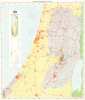
المستعمرات الإسرائيلية في المناطق المحتلة ١٩٦٧ – ١٩٩٣ / [Israeli Settlements in the Occupied Territories 1967-1993].
Second Map Printed in Palestine by a Palestinian Mapmaker.
Second Map Printed in Palestine by a Palestinian Mapmaker.
This is a scarce Arabic-language wall map of Israel-Palestine published in 1994 by Dr. Khalil Toufakji of the Arab Studies Society in Jerusalem. A map of great importance, focusing on Israeli Settlements in the Occupied Palestinian Territory, this is the second map ever printed in post-1948 Palestine and made by a Palestinian map maker.A Closer Look
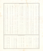
The map covers the occupied West Bank and Gaza Strip, as well as adjacent and intervening parts of Israel. Urban areas are shaded orange and connected by roads and highways traced in red. The 1949 'Green Line' de facto border is, naturally, traced in green. Topographic details and administrative borders are also indicated. However, the main focus of the map is the Israeli settlements in the West Bank and Gaza Strip, which are marked with blue stars of various sizes, reflecting their population, ranging from several dozen to tens of thousands of inhabitants. Settlements under construction and Nahal settlements, established by youth engaged in a joint military-civil service program, are also recorded. Roads built to serve the settlements are also highlighted. The map is surrounded by a grid corresponding to an index of cities, towns, and Israeli Settlements on the verso. In all, the map reflects the rapid expansion of Israeli settlements in the West Bank and Gaza between the late 1970s and early 1990s, as well as Toufakji's expertise on the topic.Evolution of Israeli Settlements in the West Bank and Gaza
When the First Arab-Israeli War ended in an armistice in 1949, a de fact border (the 'Green Line') was established between Israeli and Palestinian territories. However, in the 1967 Six-Day War, Israel occupied the West Bank (including East Jerusalem) and the Gaza Strip, territories that the international community generally regards as the Occupied Palestinian Territory under international law. Almost immediately, the Israeli government, supported by non-governmental ideological movements, began establishing settlements in these newly occupied areas. East Jerusalem was annexed and subjected to large-scale settlement construction meant to integrate it into Israel's urban fabric. In the West Bank, settlements emerged following two broad logics: strategic-military placement (e.g., in the Jordan Valley) and ideological settlement motivated by religious and nationalist movements. By the late 1970s and 1980s, settlement growth accelerated, supported by government incentives such as housing subsidies, infrastructure investment, and preferential land policies.The Oslo Accords of the 1990s created Palestinian self-governance in parts of the West Bank and Gaza but did not halt settlement expansion. Instead, the number and population of settlements grew steadily, even as negotiations aimed at creating a two-state solution proceeded. Israel withdrew its settlements from Gaza in 2005, but settlement activity in the West Bank, including East Jerusalem, continued to expand significantly. Today, settlements and their associated infrastructure (such as bypass roads, military zones, and hundreds of miles of walls) form a complex territorial network that shapes daily life, mobility, and political geography across the region. The international community, including the United Nations, widely considers these settlements to violate the Fourth Geneva Convention as well as multiple U.N. resolutions relating to the Arab-Israeli conflict, a characterization Israel disputes. Today, about 220,000 Israelis reside in East Jerusalem and over 500,000 in the rest of the West Bank, including dozens of unsanctioned 'outposts' beyond the settlements.
Publication History and Census
Though not named, this map was prepared by Dr. Khalil Toufakji of the Arab Studies Society in Jerusalem (which is named), where he was the lead cartographer and map expert, and published in January 1994. It represents only the second map printed in the Occupied Palestinian Territory by a Palestinian mapmaker. This map is quite rare, only being noted among the holdings of Stanford University, the Library of Congress, and the Institute for Palestine Studies in Beirut.Cartographer
Dr. Khalil Toufakji (خليل توفكجي; fl. c. 1980 - present) is a researcher and cartographic expert on issues relating to settlement and borders, particularly relating to Jerusalem. Toufakji received a bachelor's degree from Damascus University in 1974 and a Master's degree in Geographic Information Systems from the University of Arizona in 1998. He was he chief cartographic expert for the Palestine Liberation Organization as the head of the Maps and Survey Department at Jerusalem's Orient House (بيت الشرق), which operated as the Palestinian Liberation Organization's headquarters in the city until the building was shut down by the Israeli authorities in 2001 in the wake of a deadly suicide bombing. Due to his expertise on historical borders and maps, Toufakji was a member several delegations attending peace talks between 1992 and 2001. He has served for many years as the chief cartographer at the Palestine Geographical Center (المركز الجغرافي الفلسطيني) of the Arab Studies Society (جمعية الدراسات العربية), a nongovernmental organization founded in 1980 to research and documentation center to record the historical, cultural, and political history of Palestinians. In 2017, this center was briefly shut down by Israeli authorities, ironically due to a mapping error; it was mistakenly believed to be within the boundaries of Jerusalem but actually is located in the nearby West Bank village of al-Ram. Further Details...
Condition
Good. Some wrinkling to paper. A few repaired edge tears.
References
OCLC 950569797. Institute for Palestine Studies IPS Constantine Zurayk Library Map drawers M : W516/6.