This item has been sold, but you can get on the Waitlist to be notified if another example becomes available, or purchase a digital scan.
1795 Carey / Lewis Map of Pennsylvania
Pennsylvania-carey-1795$700.00

Title
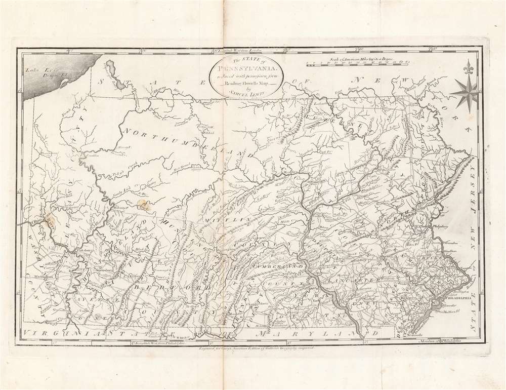
The State of Pennsylvania : reduced with permission from Reading Howell's map.
1795 (undated) 11.5 x 18 in (29.21 x 45.72 cm) 1 : 1140480
1795 (undated) 11.5 x 18 in (29.21 x 45.72 cm) 1 : 1140480
Description
This is a fine first state example of Samuel Lewis’ 1795 map of Pennsylvania for Carey's General Atlas, the first atlas published in the young American Republic. It was an especially significant map as the producers of the atlas were based in Philadelphia, also the nation’s (temporary) capital at the time, which they used as the Prime Meridian throughout the atlas.
A Closer Look
The distinctive geography and topography of Pennsylvania are clearly displayed here, with the Appalachian and Allegheny Mountains cutting across the state from northeast to southwest and feeding large rivers on either side of the state (Ohio, Allegheny, Susquehanna, Delaware). The 1792 map of Reading Howell on which this map is based was the first map to show the full extent of Pennsylvania, including the state's western border and the all-important sliver of land connecting it to Lake Erie. It was also the first map to clearly delineate Pennsylvania's county structure, forming a basis for civil administration within the state to this day. Many of Pennsylvania's towns, cities, creeks, rivers, mountains, roads, and mineral deposits appeared for the first time on Howell’s map.Publication History and Census
This map was made Samuel Lewis and engraved by Smither (perhaps James Smither - little information available about this individual) for the first (1795) edition of Carey's General Atlas (sometimes subtitled American Edition of Guthrie's Geography improved). It is based on a 1792 map of Pennsylvania produced by the surveyor Reading Howell, the first map of the Commonwealth made after independence and the most comprehensive in existence at the time. The 1795 and 1796 editions of this map are identical in presentation but can be distinguished according to their fold lines (see publication note in Rumsey Collection listings). The prevalence of the map is difficult to determine since it is sometimes cataloged independently and sometimes with the atlas, but both the individual map and the entire atlas are held by a handful of universities and research institutions in the United States and Europe.CartographerS
Matthew Carey (January 28, 1760 - September 16, 1839) was a Dublin born publisher who established himself in Philadelphia in the late 18th and early 19th century. A young man of socially progressive views, Carey's first known publication, produced when he was but 17 years old, was a pamphlet criticizing dueling. Another pamphlet, issued in the same year, attacked the Irish penal code. Shortly afterwards, in 1779, legal issues, possibly arising from his liberal political activism, forced Carey to flee to Paris. In Paris, Carey had the good fortune to befriend the visiting American diplomat and founding father, Benjamin Franklin (1706 - 1790). As an Irishman chafing under the rule of England, Carey sympathized with and admired the American revolutionary. The liberally minded pair struck up a lifelong friendship and Carey was hired to work at Franklin's press in Passy, France. A year later, Carey returned to Ireland and resumed his politically provocative publishing career with The Freemans's Journal and The Volunteer's Journal. It didn't take long for political pressure to once again force Carey from Ireland - this time to America (1784). Although largely without funds, Carey convinced Gilbert du Motier, Marquis de Lafayette (1757 - 1834), who he knew from Franklin's Paris circle, to lend him funds to establish a new publishing concern in Philadelphia. Despite this loan, Carey's firm remained under financed and opened on a shoestring budget. It was most likely his limited budget that led Carey to some of his most important publishing innovations. At the time cartographic publishing was dominated by large printing houses in London and Paris where most, if not all, of the work was completed in house. Without the finances to emulate this large publishing houses, Carey was forced to outsource much of his publishing work. This set the stage for subsequent American publishers who, in order to compete effectively with European firms, relied on an often bewildering network of alliances and collaborations. Carey was also a master of republishing many of his own maps in multiple different atlases and formats to maximize their profitability. His most important work is without a doubt the 1795 issue of the American Atlas the first atlas to be published in America. Carey died in 1839 but was succeeded by his son Henry Charles Carey (1793 - 1879) who, in partnership with his brother-in-law Isaac Lea (1792 - 1886), published numerous important maps and atlases under the Carey and Lea, Lea Brothers, and Lea and Blanchard imprints. More by this mapmaker...
Samuel Lewis (c. 1754 - 1822) was an American engraver, cartographer, draftsman, and geographer active in Philadelphia in the first of the 19th century. Though is place of birth is uncertain, most agree that Lewis emigrated from Dublin, Ireland, in the late 18th century. Lewis' earliest cartography work was produced in partnership with the well-known Philadelphia publishers Matthew Carey and Henry Schenk Tanner. In 1804, with the intention of republishing high quality English maps in the United States, Lewis partnered with the eminent British map publisher Arron Arrowsmith. Their first joint publication was A New and Elegant General Atlas, but many others followed including an American edition of Arrowsmith's important double hemisphere wall map of the world. Arrowsmith also worked with Jedidiah Morse, among other important American cartographers of the period. Ralph Brown considers Lewis to be "the most enterprising commercial map-maker of the period … " Lewis is best known for his map related to the expedition of Meriwether Lewis (no relation) and William Clark. In 1814 Lewis, copying directly from William Clark's manuscript, issued A Map of Lewis and Clark's Tracks across the Western Portion of North America. This important document was the first published map derived from the Lewis and Clark Expedition and profoundly transformed the cartography of the American northwest. Samuel Lewis of Philadelphia should not be confused with Samuel Lewis of London, another cartographer active during roughly the same period. Learn More...
William Guthrie (1708 - March 9, 1770) was a Scottish historian, journalist, and writer. Born in Brechin, he studied at Aberdeen University with the idea of becoming a parochial schoolmaster. Instead, in 1730, he elected to settle in London and try his hand at literature. He covered parliamentary debates f or the Gentleman's Magazine and soon earned a reputation for being a political writer. He published several scholarly works, including a History of England from the Invasion of Julius Caesar to 1688 in four volumes, and, most notably, his Geographical Historical, and Commercial Grammar. Learn More...
Reading Howell (1743 - 1827) was a Pennsylvania based engineer, landowner, and surveyor active in the late 18th and early 19th century. While little is known of his personal life, records do survive of his surveying projects, including detailed surveys of the Delaware, Lehigh, and Schuylkill Rivers. In 1789 he was commissioned by the assembly of Pennsylvania to, for the sum of two hundred pounds, to produce a detailed map of the state. This map, which was initially published in 1792, was the first map of Pennsylvania to be issued following the American Revolutionary War. This important document would prove to be the finest and most important map of Pennsylvania to be issued to date, incorporating, as it did, the wealth of cartographic information generated by both American and British military surveyors during the Revolution. From 1804 to his death in 1827, Howell held the title of "Principal City Surveyor" as well as "City Regulator" of Philadelphia, where his name is attached to numerous surveys related to land disputes. Learn More...
Source
Carey, M., Carey's General Atlas, (Philadelphia: Carey) 1796.
Condition
Good. Fold lines visible and some wear present along fold lines. Some minor imperfections, particularly on the left side of the map.
References
Rumsey 2542.010, 2931.034. OCLC 55716023.