
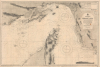
1945 British Admiralty Chart of the Strait of Hormuz and Environs


Entrance of the Persian Gulf.
Dubai - Origins of an Economic Miracle.
- Digital Map Information
- Suitable for large format printing
- File Size: 50.69 MB
- File Type: ZIP / TIFF
- ICC color profile embedded
- Delivered instantly via download link
Dubai - Origins of an Economic Miracle.
This is a 1945 British Admiralty large-format nautical chart of the Strait of Hormuz encompassing the Entrance to the Persian Gulf, one of the most strategically important locations in the world. The chart is notable for its inclusion of Dubai, at this time still a small fishing and pearling port but poised to become an economic powerhouse following the discovery of oil in the 1960s.A Closer Look
The chart covers from the southern shore of Persia (or Iran), including coastal swampy areas, Bandar Abbas, and the Island of Qeshm southwards to the eastern tip of the Arabian Peninsula, including what is now the United Arab Emirates and part of Oman, with Dubai (Dabei here) at bottom. The main maritime focus is the Strait of Hormuz. Soundings, bottoms, banks, hazards, compasses with magnetic variations, anchorages, and other navigation information are included throughout. Coastal features on land, including settlements, roads, caravan routes, ruins, minarets, and mountains (with elevations noted) are also indicated. An extensive tide chart also appears at top-right.An Economic Miracle
In 1945, Dubai was still a modest pearling and trading settlement on the Persian Gulf, far removed from today's global metropolis. The economy was fragile, as the once-lucrative pearl trade collapsed during the 1930s due to the rise of cultured pearls and the Great Depression. Trade through the creek remained the town's lifeline, with merchants dealing in goods from India, Iran, and across the Arabian Peninsula, while Bedouins supplied livestock, dates, and other products from the hinterland. Politically, Dubai was one of the Trucial States (technically part of the Raj until its dissolution) under British protection, with Sheikh Saeed bin Maktoum Al Maktoum as ruler, maintaining authority through family alliances and tribal ties. Infrastructure was minimal - there were no paved roads, electricity, or modern port facilities - and in the immediate post-World War II period, Dubai was embroiled in a border dispute with Abu Dhabi.Within a generation, Dubai would be in a completely different situation. Customs were reformed to facilitate trade, and by the 1950s, Dubai was easily one of the busiest ports in the Persian Gulf. When Saeed bin Maktoum Al Maktoum died in 1958, he was replaced by the young and reform-minded Rashid bin Saeed Al Maktoum, who dredged the Dubai Creek to make it passable for modern ships. A modern bridge was also built across the Creek, and a comprehensive town plan was laid out. At this point, Dubai was reliant on bonds and loans to pay for infrastructure, but the discovery of oil in nearby Saudi Arabia and Abu Dhabi led to a frantic search for oil in Dubai as well, which paid off when offshore deposits were discovered in 1966, followed quickly by the construction of a deep-water port. In 1971, Dubai became independent and joined the United Arab Emirates, and has since become its largest and wealthiest city.
Publication History and Census
This chart was produced by the British Admiralty in 1945, based on surveys going back to the 19th century that were updated continually afterwards. We do not locate any other examples of this edition in institutional collections or on the market. The University of Wisconsin-Milwaukee holds a 1950 edition, while a small handful of libraries hold earlier editions.Cartographer
The British Admiralty Office (1795 - Present) or the United Kingdom Hydrographic Office refers to the Branch of the English government that is responsible for the command of the British Navy. In 1795 King George III created the United Kingdom Hydrographic Office, known in short as the U.K.H.O., to provide top notch nautical charts to the vast Royal Navy. Prior the founding of the Admiralty the surveying and creation of nautical charts was primarily a commercial venture wherein the cartographer himself, more of than not, actually financed the printing of his own material. The great navigator Cook himself is known to have scrambled for funds to publish his own seminal charts - the most important and advanced of the period. The system of privately funded nautical mapping and publishing left vast portions of the world uncharted and many excellent charts unpublished. King George III, responding significant loss in trade revenue related to shipwrecks and delay due to poor charts, recognized the need for an institutionalized government sponsored cartographic agency - the Admiralty. The first head of the Admiralty, a position known as Hydrographer, was the important cartographer Alexander Dalrymple. Dalrymple started by organizing and cataloging obtainable charts before initiating the laborious process of updating them and filling in the blanks. The first official Admiralty Chart appeared in 1800 and detailed Quiberon Bay in Brittany. By 1808 the position of Hydrographer fell to Captain Thomas Hurd. Hurd advocated the sale of Admiralty charts to the general public and, by the time he retired in 1829, had issued and published some 736 charts. Stewardship of the organization then passed to Rear Admiral Sir Francis Beaufort. It was under Beaufort's administration that the Admiralty truly developed as a "chart making" as opposed to a "chart cataloging" institution. Beaufort held his post from 1829 to 1854. In his 25 years at the Admiralty Beaufort created nearly 1500 new charts and sponsored countless surveying and scientific expeditions - including the 1831 to 1836 voyage of the H.M.S. Beagle. By 1855 the Admiralty's chart catalog listed some 1,981 charts. Further Details...
Condition
Very good. Minor discolorations near title.