
1832 Berghaus 'Atlas von Asia' Map of the Philippines

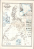
Reduzierte Karte von den Philippinen und den Sulu Inseln.
The Philippines mapped with unprecedented accuracy - the first large-scale synthesis of Malaspina and Aragón, and one of the rarest landmarks of Philippine cartography.
- Digital Map Information
- Suitable for large format printing
- Full resolution TIFF file
- ICC color profile embedded
- Delivered instantly via download link
The Philippines mapped with unprecedented accuracy - the first large-scale synthesis of Malaspina and Aragón, and one of the rarest landmarks of Philippine cartography.
This is a striking 1832 Heinrich Berghaus map of the Philippines. It was issued for Berghaus' loose-leaf Atlas von Asien, the best-informed general cartographic work on Asia to appear in the mid-19th century. It is the first large-scale map to comprehensively incorporate both the Malaspina hydrography and Ildefonso de Aragón's (c. 1826) geographical surveys. It thus offers unprecedented accuracy and the first substantial critical analysis of Philippine hydrography and cartography, making it a seminal chapter in the archipelago's mapping.A Closer Look
Coverage embraces the Philippine Islands and the Sulu Archipelago, including parts of Borneo. Along the coasts, the level of engraved detail, particularly hatching, indicates Berghaus' level of certainty: fine hatching, as is evident in western Luzon, represents confidence; fine lines indicate less certainty; and ghosting (dashed lines) indicates significant doubt. Where available, Berghaus incorporates coastal depth soundings, with the greatest detail along the coasts of Palawan and the Sulu Archipelago.There are detailed insets of Manila Bay (Bucht von Manila), the Batanes Islands (Islas Batanes), the Taal Volcano (Volcan de Taal), northwestern Borneo between Pulo Gaya and Pulo Tiga, the Darawan Islands (Maratua), Mindanao in the vicinity of Bunwut (Bongo Island), and Se Langan (Cotabato City). There are profile views of Bongo Bucht, Tetyan, Batulakki (Mindanao), Serangani (southern Mindanao), Salibabo, Kabruang (Cabong, Samar), Sangir, a passage we have not identified labeled 'Passage Inseln', south Mindanao, and Batan Island.
Sources
The map is a composite of hydrography associated with the Expedition of Alejandro Malaspina (1789 - 1794), trigonometrical and topographical surveys by Ildefonso de Aragón y Abollado, and updates from British East India ship logs, all of which were subjected to Berghaus' critical and erudite interpretation.The map benefits from the hydrography collected by Alejandro Malaspina (1754 - 1810) during his naval service in the Philippines (1777 - 84), and during his subsequent circumnavigation (1789 - 1794) on behalf of the Real Compañía de Filipinas. Malaspina and his under-officers arrived in the Philippines in March 1792 and remained in the archipelago until January 1793. The 'extensive labors by Malaspina and his officers produced a reasonably complete understanding of the coastlines of Luzon and the Visayan Islands.' Beyond such, Berghaus laments that a full understanding of the coasts remains incomplete - here only those parts of the coast rendered in fine hachure represent concrete observations from Malaspina.
Due to the War of the Pyrenees (1793 - 1795) between Spain and France, and Malaspina's political struggles (he was implicated in a plot to topple the first minister, Manuel Godoy, and sentenced to 10 years in prison), his hydrographic data on the Philippines was not published until 1808, and then in very reserved numbers (we are aware of just 4 known examples). This map is thus one of the earliest maps to incorporate Malaspina, following the Dirección de Hydrografía chart (1808), the Arrowsmith map (1812), and the Jackson / Maver map (1814, see below), and the first to make a critical interpretative assessment. Likely, Berghaus did not have access to the 1808 Dirección de Hydrografía chart, but rather the 1812 Arrowsmith, a less detailed but faithful copy. He also likely had access to some of Malaspina's journals, which, due to suppression in Spain, were first published in serialized form in a Russian naval journal from 1824 to 1827. (They were not published in Spanish until 1885.)
The interior content is derived from the maps and geographical texts of Ildefonso de Aragón y Abollado (1760 - 1838), a topographical engineer involved in a 20+ year effort to trigonometrically and topographically survey the Philippines. Berghaus had access to 9 of Ildefonso's maps, the last of which was printed in 1826, as well as 6 of his textual geographical and topographical descriptions, on which he lavishes meaningful praise, 'In accuracy and execution, these sheets may rightly be compared with similar representations of European territories.'
The Ildefonso surveys, being land-based, were more accurate than Malaspina's hydrography, thus allowing Berghaus to precisely reconcile the two cartographic models and confer upon his map unprecedented accuracy. (For the 1814 John Jackson / John Maver A Correct Map of the Philippine Islands, Berghaus has nothing but contempt, considering it an inferior slavish copy of Arrowsmith/Malaspina.)
Berghaus additionally credits British ship logs and surveys. The frequent trading voyages between India and Canton brought British East India Company ships close to the western Philippine coast, particularly when they followed routes through the eastern Sunda Straits, the Straits of Makassar, or the Moluccas. In particular, he credits the observations of James Horsburgh (1762 - 1836) and Peter Heywood (1772 - 1831), which contributed to correcting numerous positions in the western Philippines. For the northern and western coasts of the Calamianes and Palawan, he credits Daniel Ross (1780 - 1849).
Fictional Island of San Juan
Of some interest is the fictional Isla de San Juan (Island of St. John) appearing just east of Tadag (Tandac), Mindanao. Berghaus had considerable doubt about the island's existence, but ghosts it in, suggesting uncertainty. The island has a long cartographic history, being referenced by Herrera, Valentyn, and Dampier, among others. Berghaus suggests that Admiral James Burney, in his Chronological History of the Voyages and Discoveries in the South Sea or Pacific Ocean (Vol. IV, London, 1816, p. 243), correctly identifies the island as a misunderstanding Cape St. Augustine (Co. Sn. Augustin) and the Davao Gulf (B. Tagloc), which, admittedly, is here considerably underestimated (as in the Malaspina, but less so).Publication History and Census
This map was published in 1832 by Heinrich Berghaus and Justus Perthes. It was engraved by Selmar Siebert. The map is no. 13 in Berghaus's Atlas von Asien. Like most maps of the Atlas von Asien, it is of the utmost rarity, with OCLC cataloging just 2 examples, both in German libraries, and a third example in Switzerland. In private hands, we are aware of a single example, held in a Philippine collection.Cartographers
Heinrich Karl Wilhelm Berghaus (May 3, 1797 - February 17, 1884) was a German (Prussian) geographer, linguist, and ethnologist who founded the Potsdam Geographische Kunstschule. He was born in Kleve, Germany, and, as a young man, trained as a surveyor. He put his training to work in 1811, working in the French Department of Lippe as a bridge and road engineer. When the Kingdom of Westphalia dissolved in 1813, he volunteered for the Prussian army administration, traveling with General Bogislav Friedrich Emanuel von Tauentzien (1760 - 1824) as far as Brittany. In 1816, he joined the staff of the Prussian trigonometrical survey, conducting surveys throughout the nation. Among his many accomplishments, Berghaus is credited with inventing the 'thematic atlas' in 1845. In addition to his own work, he trained some of the most important German geographers and cartographers of the late 19th century, including August Heinrich Petermann (1822 - 1878) and his nephew Hermann Berghaus (1828 - 1890). The elder Berghaus also was a friend and associate of the naturalist Alexander von Humboldt (1769 - 1859), producing some of the maps in his publications. In 1837, he inherited rights to Daniel Gottlob Reymann's (1759 - 1837) monumental Geographischer Specialatlas von Deutschland. Berghaus is best known for his own influential and wide-ranging atlases, namely Atlas von Asien, published between 1833 and 1837, and Berghaus' Physikalischer Atlas, published in multiple editions in the 1830s - 1840s. Although Atlas von Asien was a commercial failure, it was regarded as a work of supreme quality, boosting the reputation of the publisher Justus Perthes and setting up their next collaboration, Berghaus' Physikalischer Atlas, for success. In addition to his geographical work, Berghaus was also an accomplished linguist and ethnologist and published an important 1851 article on American Indian language and ethnology (Geographisches Jahrbuch, 1851). Further Details...
Johan Georg Justus Perthes (September 11, 1749 - May 2, 1816) was one of the most important German cartographic engravers of the 19th century. He was born in the Thuringian town of Rudolstadt, the son of a court physician. In 1778, he began working as a bookseller in Gotha. Perthes began his publishing empire shortly thereafter with the 1784 issue of the famed survey of European nobility known as the Almanac de Gotha. In the next year, 1785, he founded the cartographic firm of Justus Perthes Geographische Anstalt Gotha. His son Wilhelm Perthes (1793 - 1853) joined the firm in 1814. Wilhelm had prior publishing experience at the firm of Justus Perthes' nephew, Friedrich Christoph Perthes, who ran a publishing house in Hamburg. After Justus Perthes died in 1816, Wilhelm took charge and laid the groundwork for the firm to become a cartographic publishing titan. From 1817 to 1890. the Perthes firm issued thousands of maps and more than 20 different atlases. Along with the visionary editors Hermann Berghaus (1797 - 1884), Adolph Stieler (1775 - 1836), and Karl Spruner (1803 - 1892), the Perthes firm pioneered the Hand Atlas. When Wilhelm retired, management of the firm passed to his son, Bernhardt Wilhelm Perthes (1821 – 1857). Bernhardt brought on the cartographic geniuses August Heinrich Peterman (1822 - 1878) and Bruno Hassenstein (1839 - 1902). The firm was subsequently passed to a fourth generation in the form of Berhanrd Perthes (1858 – 1919), Bernhard Wilhelm's son. The firm continued in the family until 1953 when, being in East Germany, it was nationalized and run as a state-owned enterprise as VEB Hermann Haack Geographisch-Kartographische Anstalt Gotha. The Justus family, led by Joachim Justus Perthes and his son Wolf-Jürgen Perthes, relocated to Darmstadt where they founded the Justus Perthes Geographische Verlagsanstalt Darmstadt. Further Details...
Source
Berghaus, H., Atlas von Asien, (Gotha: Justus Perthes) 1832 - 1837.
Heinrich Berghaus's Atlas von Asien was an 18-map loose-leaf atlas issued by Justus Perthes between 1832 and 1858. Of the 18 proposed maps, only 15 were published. Individual maps were large with unprecedented detail. These include 10 land maps and 7 nautical charts derived from British, Dutch, and Portuguese colonial, scientific, and diplomatic missions. Despite this, the project was a financial failure due to the high cost of engraving such large and intricate maps. It took more than 25 years for the maps to be fully published and, according to the Perthes archive, only 20 sets were ultimately bound and sold. The publication run per map ran between 200 to 550 maps, most of which were offered separately. The breadth, detail, and comprehensiveness of the work surpassed any previous mapping of the respective subjects. Although not a direct financial success, the Atlas von Asien was a monumental cartographic accomplishment that put the Perthes firm on par with the great cartographic firms of England and France. The Atlas von Asien was largely forgotten until recent times, when it has become desirable among collectors and institutions.
Condition
Very good. Minor foxing.
References
Basel Mission Archives, BMA 98653. OCLC 557003866. Berghaus, H., Geo-hydrographisches Memoir zur Erklärung und Erläuterung der reducirten Karte von den Philippinen und den Sulu-Inseln, (No. 13 von Berghaus’ Atlas von Asia.) Gotha, Perthes (1832) 4°, 114.