
1960 Sims Pictorial Map of the City of London, England

This item has been sold.
The City of London. / The City of London Pictorial Map.
London's Historic Core.
Choose a Collection:
This Item
Enquire
London's Historic Core.
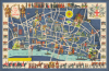
This is a c. 1960 Mary Sims pictorial historical map of the City of London, the historic core of London, England. It provides a colorful overview of the city's long history and development from antiquity to roughly 1960.A Closer Look
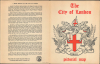
This vibrant map covers the City of London, the basis for the later metropolis of Greater London, which is cobbled together from the City of London and surrounding towns (including the City of Westminster), parishes, and counties. Historic landmarks are illustrated throughout, including the towering St. Paul's Cathedral, which historically dominated the skyline, additional churches, the Tower of London, train and Tube stations, bridges, halls of the City's Livery Companies (professional guilds), the Bank of England, St. Bartholomew's Hospital, and more. The border includes the City's coat of arms, the coats of arms of the twelve largest Livery Companies, and a depiction of the Lord Mayor's procession at bottom to match a scene coving different eras in the City's history at top. The cover provides a brief history of the City and a larger coat of arms.The City of London
The City of London, often called simply 'the City,' is the roughly one-square-mile historic heart of London and one of the oldest continuously inhabited parts of Britain. Founded by the Romans around 47 CE as Londinium, it developed along the River Thames as a strategic port and commercial hub of Roman Britain. By the 2nd century, Londinium was enclosed by defensive walls - remnants of which still define the City's boundaries today - and had become a bustling center of trade and administration. After the collapse of Roman rule, the area declined but was later revived by the Anglo-Saxons and further strengthened following the Norman Conquest, when the Tower of London was built nearby. Throughout the Middle Ages and even into the 21st century, the City retained a unique autonomy, governed by its own institutions such as the Lord Mayor and the ancient livery companies. Despite the devastation of events like the Great Fire of 1666 and the Blitz during World War II, the City remained the financial and commercial nucleus of Britain. Today, it is a modern global financial district layered upon nearly two millennia of continuous urban history.Publication History and Census
This map was prepared by Mary Sims and published by Golden Galleon Press around the year 1960 (the Mermaid Theatre at Puddle Dock at bottom, towards left opened in 1959). It is not recorded in the OCLC or otherwise in institutional collections.Condition
Very good. Light wear along original fold lines. Verso reinforcement at a fold intersection. Accompanied by original binder.