This item has been sold, but you can get on the Waitlist to be notified if another example becomes available, or purchase a digital scan.
1884 Sargent Arboreal Map of North America Depicting Pine Trees
Pinus-sargent-1884$150.00

Title
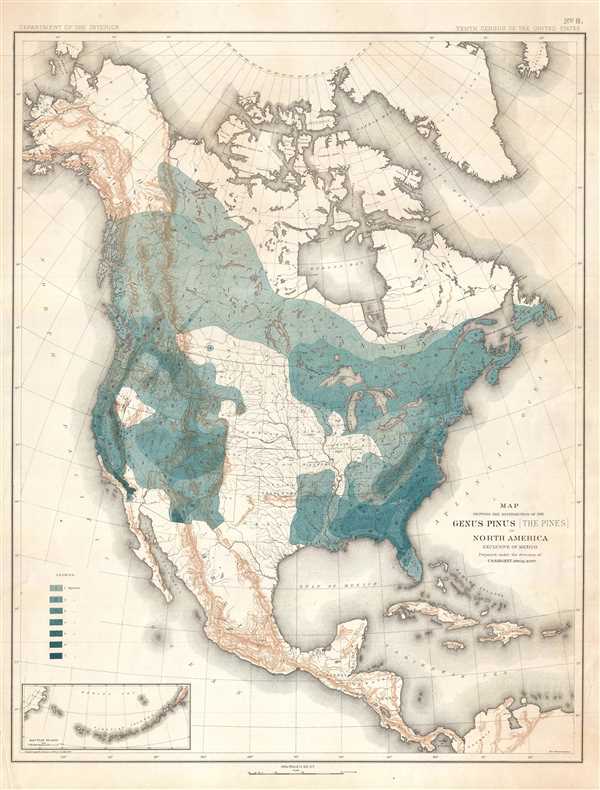
Map Showing the Distribution of the Genus Pinus (the Pines) in North America Exclusive of Mexico.
1884 (undated) 23 x 17.5 in (58.42 x 44.45 cm) 1 : 15300000
1884 (undated) 23 x 17.5 in (58.42 x 44.45 cm) 1 : 15300000
Description
This is an 1884 Charles Sprague Sargent arboreal thematic map of North America. The map depicts the continent of North America from the Arctic Ocean, Alaska, and Canada south to Mexico and Central America as well as the extreme northern reaches of South America and from the Pacific Ocean to the Atlantic. It was a part of a portfolio entitled Sixteen Maps Accompanying Report on Forest Trees of North America, which accompanied the 1884 Department of the Interior Report on Forests of North America (Exclusive of Mexico), itself a part of the United States Census of 1880.
As the title suggests, the purpose of the map is to illustrate the distribution of genus Pinus, or pine, trees. A legend along the left border explains that the seven different colors present on the map indicate that seven different species of pine tree inhabit the United States and Canada. Pine trees are any type of conifer in the genus Pinus, which, per the map, are native to large portions of both the United States and Canada, with the exception of the extreme northern portion of Canada, the Plains states in the U.S., and Alaska.
Although created to illustrate the distribution of pine trees, several other aspects of the geography of North America are also depicted. Myriad rivers are labeled, as well as all the contemporary states, which at the time included the Indian Territory and Dakota as well as the Alaska Territory. State capitols and other major cities are labeled. Mountain ranges are depicted in both North and Central America. An inset map is located at the lower left corner and depicts the Aleutian Islands and Kamchatka.
This map was prepared under the direction of Charles Sprague Sargent, drafted by Harry King, and compiled under the direction of Henry Garrett. The map is number eight of the portfolio titled Sixteen Maps Accompanying Report on Forest Trees of North America which accompanied the 1884 Department of the Interior Report on Forests of North America (Exclusive of Mexico) and was published by Julius Bien in New York.
CartographerS
Charles Sprague Sargent (1841-1927) was an American botanist who was the first director of Harvard's Arnold Arboretum, a post which he held for 54 years. Sargent graduated from Harvard College in 1862 with a degree in Biology and immediately joined the United States Army and served in Louisiana during the Civil War. Following his time in the army, Sargent spent three years touring the botanical gardens of Europe. Upon his return, he took it upon himself to care for the grounds of his family estate, Holm Lea in Brookline, Massachusetts. In 1872, Sargent was appointed as a professor of horticulture at the newly formed Bussey Institution and in 1873 was named Director of the Arnold Arboretum. The Arboretum slowing began to take shape in the years following his appointment, and, beginning in 1878, Sargent began working with the renowned landscape architect Frederick Law Olmstead on a path and roadway system. In 1880, Sargent's expertise was called upon by the Department of Forestry to conduct a census of the trees of the United States by region, which was published in 1884 as Report on the Forests of North America (exclusive of Mexico). Sargent was influential in the creation of both national forests and national parks over the course of his career. It is said that Sargent spent all his waking hours either working in the administration building that he had raised the funds to have built, or wandering the grounds of the Arboretum. His expertise was renowned, even his own staff considered him to be a 'one-man institution'. After Sargent's death in 1927, Massachusetts Governor Alvan T. Fuller planted a white spruce on the grounds of the Massachusetts State House in his memory, stating, 'Professor Sargent knew more about trees than any other living person. It would be hard to find anyone who did more to protect trees from the vandalism of those who do not appreciate the contribution that they make to the beauty and wealth of our nation.' More by this mapmaker...
Henry Gannett (August 24, 1846 - November 5, 1914) was an American geographer who is described as the 'Father of American topographic map making'. Born in Bath, Maine, Gannett entered Harvard at the age of twenty and received a bachelor's degree in 1869. He earned the degree of mining engineer from the Hooper Mining School in 1870. He joined the Hayden Survey in 1871, at the age of twenty-one, and continued worked for its successor, the U.S. Geological Survey until his death. Gannett was among those lobbying to centralize all government mapmaking under one agency. Before the creation of the United States Geological Survey, individual mapmakers and agencies had to compete for money from Congress to fund projects. He became chief geographer of the U.S. Geological Survey, a position he held for fifteen years. Most of the Survey's map-making methods developed during his tenure as chief geographer. Gannett also earned a reputation as an indefatigable compiler of geographic materials. His first job with the USGS was geographer of the 1880 United States Census. The completion of the census in 1882 is considered the start of true topographical work in the United States and the birth of the quadrangle. Gannet served as chief geographer on two subsequent censuses, 1890 and 1900, and was one of the founding members of the National Geographic Society. Gannett was also one of the founders of the Association of American Geographers and the Geological Society of America. Gannet organized the Board of Geographic Names, which became a permanent part of the federal government and considers geographic names in official use. Gannett served as chairman of this Board from 1894. Upon his death, the Annals of the Association of American Geographers lamented, 'in the death of Henry Gannett American Science has lost one of the pioneers who had an important share in the development of geography in this country into an organized science'. Gannett married Mary E. Chase in 1874 with whom he had two daughters and a son. Learn More...
The United States Geological Survey (1878 - Present), aka the U.S.G.S., is a scientific agency of the United States government, which was founded in 1879. USGS scientists study the landscape of the United States, its natural resources, and the natural hazards that threaten it. The organization has four major science disciplines: biology, geography, geology, and hydrology. It is a bureau of the United States Department of the Interior and is the department's only scientific agency. Learn More...
Source
Sargent, C.S., Sixteen Maps Accompanying Report on Forest Trees of North America (New York: Bien) 1884.
Condition
Very good. Even overall toning. Blank on verso.
References
OCLC 431578544.