1886 Edmonds 'First Transcontinental Railroad Map' of Canada / Canadian Pacific
RailwaysofCanada-burland-1886$7,500.00


Title
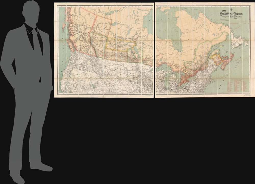
Map Shewing the Railways of Canada to Accompany Annual Report on Railway Statistics.
1886 (dated) 45.5 x 95 in (115.57 x 241.3 cm) 1 : 2660000
1886 (dated) 45.5 x 95 in (115.57 x 241.3 cm) 1 : 2660000
Description
The is the first official map of the Canadian Pacific Railroad issued after the railroad's completion in 1885. This map is of critical importance to the development of the Canadian Confederation, as well as the first complete map of the second North American intercontinental railroad. This enormous map was issued in 1886 by A. M. Edwards and Canadian Government Railways. Depicting the entire country in two sections, the map identifies ninety-three different railways throughout Canada - but the focus is the impressive Canadian Pacific Route, which stretches from Montreal to British Columbia. Maritime routes between North America and Europe and Asia, which connected to the Railroad and were part of the Canadian Pacific's marketing model, are also noted.
A Canadian Birth Certificate
This map marks the completion of the Canadian Pacific Railway, an event whose social, economic and political ramifications cannot be underestimated. One of the conditions for the western provinces, particularly the desirable and hotly contested British Columbia, to sign the 1867 'Act of Confederation' was the completion of a Transcontinental Railroad that could both unite the country and liberate it from U.S. interests. Although the railroad was initially mired in political infighting, its completion in 1885 proved a watershed moment for Canadian sovereignty and growth. By linking British Columbia and the Western Territories, including the newly formed province of Manitoba to the former British colonies of Upper and Lower Canada, including New Brunswick, Prince Edward Island and Nova Scotia, the claims to Canadian sovereignty were solidified and Western expansion could proceed. Furthermore, by linking the east and west with a railway system fully within the Canadian political entity, the historically north-south trade patterns could be altered to an east-west axis, thus offering Canada economic independence from the United States. It also put Canada in a position to move both settlers and military forces across the continent quickly and efficiently, allowing them to defend their vast but largely unsettled claims.The Canadian Pacific Railway
The Canadian Pacific Railroad was first proposed under Canadian Prime Minister John A. Macdonald and businessman Sir Alexander Tilloch Galt. The proposed route extended westward from established Ontario and Quebec railroad networks to the Pacific. The challenges were political, economic, and logistic. A fully Canadian route would require crossing 1,600 km (990 mi) of rugged terrain across the barren Canadian Shield, the muskeg of Northern Ontario, through unfriendly Blackfoot American Indian Lands, and across the Selkirk Mountains of British Columbia. The government offered huge incentives, including vast land grants in the west, to encourage emigration, development, and a demand for the railroad. Construction began in 1881. Eventually, at enormous cost and against near constant opposition, the route was completed. The last spike was driven on November 7, 1885, at Craigellachie, British Columbia. The first transcontinental passenger train departed from Montreal's Dalhousie Station, located at Berri Street and Notre Dame Street at 8 pm on June 28, 1886, and arrived at Port Moody at noon on July 4, 1886. While the railroad was thus complete, it operated mainly through undeveloped wilderness. The CPR developed revolutionary options to encourage colonists west, including over 1000 'Colonist Cars', low-budget sleeper cars designed to transport immigrant families and their possessions across the country. Ultimately, the completion and continued operation of the railroad proved a major force in the coast-to-coast development of modern Canada.Publication History and Census
This map was drawn by A.M. Edmonds, compiled by E.V. Johnson of the Canadian Government Railways, lithographed by the Burland Lithographic Company of Montreal, and sold by Edward Stanford. Six examples are cataloged in OCLC and are part of the institutional collections at the University of British Columbia, the David Rumsey Map Collection at Stanford University, Harvard College, the Boston Athenaeum, the University of Toronto, and the Newberry Library.CartographerS
Alfred M. Edmonds (1821 - November 23, 1893) was a Canadian cartographer, draughtsman, and artist. Born in Bishopstone, England, it is unclear when Edmonds immigrated to Canada. He was a school teacher in Burnstown, Ontario in 1863, and also appeared in a directory as a draughtsman that year as well. He created a sketchbook for the Haycock Iron Mine in Cantley, Quebec, in 1872. He worked as a cartographer for the Canadian Pacific Railway and the Canada Department of Reailways and Canals from 1881 until his death. In 1884, Edmonds worked as an assistant to Sir Sandford Fleming, the head of the Canadian Intercontinental Railway. At the time of his death, on November 23, 1893, Edmonds was an inmate at a local jail. At the time of his arrest on February 27, 1893, Edmonds was described as 'a pale, delicate-looking man, who it is thought was insane'. The coroner, after the inquest into Edmonds's death concluded, stated, 'We wish...to expess our disapproval in the detention in jail of such a case...which was one for a charitable institution.' More by this mapmaker...
Sir Collingwood Schreiber (December 14, 1831 - March 23, 1918) was an English Canadian engineer, surveyor, and civil servant, most remembered for helping to complete the Canadian Pacific Railway. Born in Bradwell-on-Sea, Essex, England, Schreiber arrived in Canada with his family in 1852 after being educated in England. He soon found work with the Toronto, Hamilton, and Buffalo Railway as a railroad engineer. In 1856, Schreiber left the Toronto, Hamilton, and Buffalo to work with Sir Sandford Fleming. He spent the next several years working for private railways before receiving his first government job in 1864. By 1873 he had been named chief engineer of all Canadian government railways. Schreiber became the chief engineer on the Canadian Pacific Railway in June 1880, replacing Fleming. Less than a month later Schreiber was named general manager of all operating goverment railroads. When the Canadian Society of Civil Engineers was founded in 1887, Schreiber was a founding member. He became Deputy Minister of Railways and Canals in 1892. Schreiber continued to work in government until his death in Ottawa in 1918. Learn More...
George Bull Burland (1829 - 1907) was an Irish-Canadian printer and publisher. Born in Ireland, Burland and his family immigrated to Canada in the 1840s. He found a job with the Hamilton Gazette, a newspaper owned and edited by his uncle, in 1844. Around 1848 Burland moved to Montreal and began working with George H. Matthews, an engraver and printer. Burland bought Matthews's business in 1864, along with his partners George Lafricain, Nathaniel Barber, and George Bishop, and formed Burland-Lafricain and Company in Montreal. Specialists in lithography, within a few years Burland-Lafricain bought out their closest competitor which was owned by Williasm Cumming Smillie. This company became the British American Bank Note Company, which printed banknotes, postage stamps, and other related materials. Burland began serving as vice president in 1866, and held the position of President from 1881 until his death. Burland founded his own printing company, Burland Lithographic, in the 1870s. At first, he formed a partnership with Goerges-Édouard Desbarats, and then he operated the business on his own. Burland Lithographic printed books, maps, and periodicals, including the Canadian Illustrated News. Burland was alsp a philanthropist with great interest in public health. He married Clarissa Healy Cochrane in 1857. Learn More...
Condition
Very good. Dissected and mounted on linen.
References
Rumsey 0121.001. OCLC 953568709.