
1775 Almon Map of Boston during the Siege, American Revolutionary War

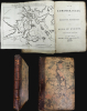
Map of the Environs of Boston. Drawn at Boston in June 1775. / The Remembrancer, or Impartial Repository of Public Events.
One of the Earliest Obtainable Maps of the American Revolution
One of the Earliest Obtainable Maps of the American Revolution
This is the scarce 1775 first volume of John Almon's The Remembrancer, which includes one of the earliest published maps of Boston following the Battle of Bunker Hill. Almon, who was a well-connected and informed reporter on the British Parliament, placed himself in danger of being fined or imprisoned by responding to public interest in events in America and publishing this work.A Closer Look
This 'Map of the Environs of Boston' presents the Shawmut Peninsula barely connected with the mainland of Massachusetts across the 'Boston Neck,' a strategic chokepoint. Surrounding towns (Dorchester, Cambridge, Charlestown), islands, forts, fortifications, and other features are noted, with a focus on the camps, positions, ships, and floating batteries of British soldiers and sailors. The 'Provincial' (Colonial) headquarters in Cambridge (soon to be occupied by Gen. George Washington), appears at left.The book itself consists mostly of excerpts from newspapers and periodicals from the preceding months providing background on the increasing tensions between Great Britain and the North American colonists. Almon's preface (advertisement), signed two days before the Battle of Bunker Hill, correctly predicted 'Many events are expected during the Summer,' the reports on which would then be compiled for the next volume of The Remembrancer. Aside from the map, the book is an extraordinary historical reference, tracing the breakdown in relations between Britain and her colonists, leading to tension, violence, and ultimately outright war.
Importance of Almon's Map
Almon appears to have prepared this map himself, cobbling together information from existing maps, perhaps copies of manuscript maps made by British military surveyors in Boston, and accounts of the recent events in Boston that made it back to Britain. Given his proximity to parliamentarians, Almon would have had access to privileged information available to few others. In a fit of Bostonian pride, 19th-century historians such as Justin Winsor and Nathaniel Bradstreet Shurtleff (also a Mayor of Boston) tended to scorn this map for its geographical inaccuracies, but there can be no doubt that it satisfied intense public interest in Britain about events in the American colonies, and was among the first maps of Boston to be published after the Battle of Bunker Hill (the Gentleman's Magazine published 'A Map of 100 Miles round Boston' in June 1775 refers to the position of troops, but it was, like Almon's, prepared before the battle took place, while Isaac de Costa's 'A Plan of the Town and Harbour of Boston and the Country adjacent' was published on July 29, and Sayer and Bennett's 'The Seat of War, In New England by an American Volunteer' is dated September 2, within a week of Almon's publication).Battle of Bunker Hill
The Battle of Bunker Hill on June 17, 1775, was one of the earliest and most important battles of the American Revolutionary War. Although identified as 'Bunker Hill', the actual battle was on Breed's Hill nearby. British forces quartered in Boston, which was then a peninsula, were easily contained by Colonial forces controlling a few chokepoints and high points in the surrounding hills. Bunker and Breed's Hills were fortified by Colonials when reconnaissance discovered that British forces were about launch an offensive against the surrounding hills - thus securing Boston.The overconfident British sailed across the Charles River in a direct assault on the well-fortified positions. Although more numerous, better trained, and better equipped, the British forces were thrown back twice before ultimately taking the defensive fortifications on Breed's Hill, earning a pyrrhic victory with over 1,000 casualties versus less than half that number for the Colonials. Moreover, many of the British casualties were officers and command staff, a crippling setback that undermined British confidence and caused them to adopt a cautious approach in future campaigns. Conversely, the Revolutionaries' militia troops were bolstered after having stood up to British regulars.
Nearly simultaneously to the battle near Boston, the Second Continental Congress established the Continental Army and appointed George Washington as its commander. As a result of the Battle of Bunker Hill, King George III issued the Proclamation of Rebellion, which marked a 'point of no return,' after which the possibility of negotiation was closed. In the months after the Battle of Bunker Hill, no major land battles took place, but the British were unable to break the Colonials' encirclement of Boston. Once reinforced by guns seized from Fort Ticonderoga, Washington was in a commanding position, which forced the British to flee the city in March 1776.
Provenance
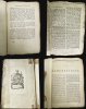
This book contains a pastedown bookplate on the inside cover with a family seal and the name 'Richard Fisher.' This image aligns with that included in the William Augustus Brewer bookplate collection at the University of Delaware (No. 4111). It may be the bookplate of Richard Fisher (1809 - 1890) of Hill Top, Midhurst (Sussex), a noted book collector, primarily of early Italian prints and printed books, but also in several other fields (His son, R. C. Fisher, continued to build their collection.) The book was subsequently was auctioned in the early 20th century. The present example was acquired in Sussex in the mid-20th century (see below) would support this Richard Fisher being the original owner, and the small bird above the two lions side-by-side on the shield may be a kingfisher, which was Fisher's collector's mark, a pun on his name. However, the image here does not otherwise correspond to textual descriptions of Fisher's collector's mark, nor the images of it included on the website version of Frits Lugt's standard reference work Les Marques de collections de dessins and d'estampes .Instead, auction catalogs and other records refer to items with a bookplate of a presumably different, distinct Richard Fisher concentrating around a fairly narrow focus on mid-late 18th century works, mostly relating to Britain's North American colonies. The Catalogue of British and American book plates bequeathed to the British Museum by Sir Augustus Wollaston Franks suggests that the present crest belongs to a descendant or close relative of Brice Fisher (d. 1767), a Member of Parliament for Malmesbury and then Boroughbridge, and one-time Director of the infamous South Sea Company (after it had caused a financial crisis in Britain, largely given up slave trading, and shifted focus to Arctic whaling expeditions).
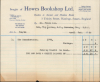
Whatever the identity of Richard Fisher, this example of the book eventually made its way to Howes Bookshop in Sussex, where it was purchased in April 1956 by Mr. Frank Cox (likely Frank B. Cox, a draftsman) of Roanoke, Virginia.
Publication History and Census
This volume of the 1775 edition of John Almon's The Remembrancer, or Impartial Repository of Public Events was published on August 28, 1775, less than three months after the Battle of Bunker Hill. The map is independently cataloged among the holdings of the Library of Congress, the University of Michigan, the Peabody Essex Museum, Pennsylvania State University, the New York Public Library, and the Bibliothèque nationale de France, while The Remembrancer is somewhat more widely distributed, though multiple editions are often cataloged together, making a full census of this particular 1775 edition difficult to establish.Cartographer
John Almon (December 17, 1737 - December 12, 1805) was an influential British political journalist, writer, bookseller, and publisher of the late 18th century. Almon was born in Liverpool and apprenticed as a printer before spending two years at sea and then moving to London to pursue a career as a writer. Almon quickly aligned with the opposition Whigs and became their main mouthpiece in the London press. Aside from writing his own Parliamentary reports, Almon opened a bookshop in Picadilly that sold political pamphlets and treatises. He quickly attracted attention and courted controversy, regularly putting himself at risk of censorship or arrest; his 1773 article on the sale of an office by John Montagu, the 4th Earl of Sandwich (namesake for the islands and food), cost the London Evening Post a hefty fine. Almon played an important role in establishing the principle of freedom of the press in Britain. Along with radical politician (one-time Mayor of London) and fellow political journalist John Wilkes (1725 - 1797), he won legal recognition of the right of printers to publish Parliamentary debates verbatim. Previously, printers could be arrested and jailed for such publications. However, Almon was protected through his position as an Alderman of London and attempted to protect other printers from this position. In 1774, he began publishing Parliamentary Register, a monthly report on Parliamentary debates. Like Wilkes, Almon was a supporter of the American colonists in their struggle for independence, reprinting Thomas Paine's Common Sense (with changes to accommodate the censors) and publishing a monthly magazine, The Remembrancer, about events in America. Almon's willingness to challenge the authorities gained him readers and a small fortune, but later in life he suffered several setbacks, including a failed effort to launch a newspaper, the loss of a libel suit after criticizing William Pitt, the Younger that led to his imprisonment for fourteen months, and debts and political pressure that caused him to flee the country for France for several years. Although he lived the rest of his life on bail for his earlier imprisonment, Almon continued to write and publish regularly into his last years. Further Details...
Condition
Good. 257 pages plus 3 pages of index. Original binding, worn but intact. Octavo. Map of Boston tipped into book opposite title page.
References
Boston Engineering Department, List of Maps of Boston, p. 24; Jolly, Maps of America in Periodicals Before 1800, #274; Nebenzahl, A Bibliography of Printed Battle Plans of the American Revolution, #4; and Winsor, Narrative and Critical History of America, vol. VI pp. 208-209. Shurtleff, N., A Topographical and Historical Description of Boston (Boston: 'Printed at the request of the City Council') 1871, pp. 95 et passim. Howe, E.R.J., Catalogue of British and American book plates bequeathed to the British Museum by Sir Augustus Wollaston Franks, Vol. 1, (London: Trustees of the British Museum) 1903, pp. 298.