
1824 Ruga City Map or Plan of Rome, Italy

This item has been sold.
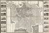
Pianta della Citta di Roma con la Indicazione di Tutte le Antichita e Nuovi Abbellimenti.
A beautifully engraved case map highlighting all of Rome's ancient and modern sites.
- Digital Map Information
- Suitable for large format printing
- DPI: 600
- File Size: 128 MB
- File Type: ZIP / TIFF
- ICC color profile embedded
- Delivered instantly via download link
A beautifully engraved case map highlighting all of Rome's ancient and modern sites.
This is a strikingly engraved 1824 Pietro Ruga folding city plan or map of Rome, Italy. The map depicts Rome from the Vatican to the Basilica of the Holy Cross in Jerusalem (Bas. di S. Croce in Gerusaleme) and from the Piazza del Popolo to the San Sebastiano Gate. A spectacularly detailed masterpiece, Ruga's map is an ichnographic plan. This means that large historic sites, like the Colosseum, the Baths of Caracalla, and the Pantheon, and others are illustrated as horizontal cross-sections, revealing detailed floor plans. Numerous churches and basilicas, including St. Peter's, are illustrated thus. All fourteen of Rome's Rioni are identified by Roman numerals and correspond with an index in the lower right. An extensive index of the city's monuments occupies part of both the left and right side panels. Sixteen detailed monument views create the left and right borders. These include a mélange of ancient and modern sites, among them St. Peter's Basilica, the Pantheon of Agrippa, the Roman Forum, the Colosseum, and the Basilica of St. Paul.Publication History and Census
This map was created by Pietro Ruga and published by Venanzio Monaldini in 1824. Several editions of this map were published beginning in 1818 through at least the late 1840s, most likely for the well-educated traveler visiting Rome on the Grand TourCartographers
Pietro Ruga (c. 1772 - 1850) was an Italian engraver, printmaker, furniture designer, and architectural draftsman active in Rome during the late 18th and early 19th centuries. Ruga was born in Rome, Italy. He is best known today for his architectural views of Italian, in particular Roman, monuments, furnishings, and antiquities. There are only two maps attributed to Ruga, both tourist pocket plans of Rome, dating to the 1820s. Pietro Ruga the engraver should not be confused with Pietro Ruga Romano, who lived in Rome at the same time and taught civil law at the Sapienza. Further Details...
Venanzio Monaldini (fl. c. 1765 - 1849) was a late 18th and early 19th century bookseller, book publisher, and map publisher based in Rome, Italy. His work appears as early as the 1760s and as late as 1849. It is unfortunately unclear if his opus represents a single individual or an an ongoing family enterprise. Monaldini's publications focused on maps and guides intended for the Grand Tour set, many of which he published in English. Monaldini, along with Arthur John Strutt, also published the weekly Roman Advertiser: Journal of Science, Literature and the Fine Arts from October 24, 1846 to April 21,1849. The bookshop, Venanzio Monaldini Librario e Cartolaro, was located on Piazza de Spanga no. 79, just opposite the Spanish Steps, Rome, Italy. Further Details...
Condition
Very good. Dissected and mounted on linen in 32 panels. Light wear along original fold lines. Blank on verso.
References
OCLC 934656203.