1662 Blaeu Map of Estonia and Russia
RussiaEstonia-blaeu-1662$1,500.00
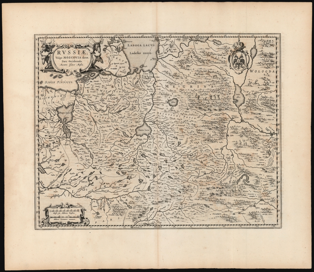

Title
Russiae, vulgo Moscovia dictae, Para Occidentalis. Auctore Isaaco Massa.
1662 (undated) 15.25 x 19.25 in (38.735 x 48.895 cm) 1 : 2000000
1662 (undated) 15.25 x 19.25 in (38.735 x 48.895 cm) 1 : 2000000
Description
This is a handsome, first edition example of Blaeu's 1662 map covering from Moscow to Estonia, and part of Lithuania, including the frontier with the Swedish Empire. This is among the rarest Blaeu atlas maps of Russia, being one of those first appearing in Joan Blaeu's 1662 Atlas Maior. The map would only appear in the five editions of that atlas before the Blaeu warehouse burned in 1672.
The network of rivers and lakes is depicted in detail, essential in penetrating what is presented as a heavily forested wilderness. Routes both along the rivers and connecting points between the rivers are indicated with the positions of key stops tracing travelers' routes from Russian ports on the Ladoga to Moscow. In addition to the pictorial representations of forests and mountains, the map depicts game animals: reindeer, moose, foxes, and wolves. A quartet of spear-bearing hunters close in on a pair of unfortunate bears. The cartouche on the upper left is flanked with a quartet of moose heads; the upper right bears the Russian coat of arms.
A Closer Look
The map's western limit includes both Estonia and what is now modern Latvia. Braslaw (in modern Belarus) appears at the southwest, just south of the Daugava River (Duna). The southern limit contains Russia's Smolensk Oblast - Smolensk itself appears within the southern border, along the Dnieper (here given its classical name Boristrenis or Borysthenes). Moscow is in the lower right-hand corner. Yaroslavl and Pereslavl are also included. To the north, part of the Finnish Sea appears - Narva is shown on the coastline. Lake Ladoga's southern shore is depicted, connected to the Finnish Sea by the Neva River, dividing Ingria in the south from Carelia in the north. Both of these latter were then under Swedish control, and that empire's border is indicated with a dotted line.The network of rivers and lakes is depicted in detail, essential in penetrating what is presented as a heavily forested wilderness. Routes both along the rivers and connecting points between the rivers are indicated with the positions of key stops tracing travelers' routes from Russian ports on the Ladoga to Moscow. In addition to the pictorial representations of forests and mountains, the map depicts game animals: reindeer, moose, foxes, and wolves. A quartet of spear-bearing hunters close in on a pair of unfortunate bears. The cartouche on the upper left is flanked with a quartet of moose heads; the upper right bears the Russian coat of arms.
Sources
In the cartouche, Blaeu credits the map's detail to Dutch trader and diplomat Isaac Massa (1586 - 1643), whose experience in Russia during the Time of Troubles (1598 - 1613) remained the best firsthand source on Russian society and geography well into the 17th century. Indeed, via the Dutch map and chartmaker Hessel Gerritz, Massa's traveler's knowledge would spread throughout the Dutch cartographic establishment. The granular detail for the trade routes shown in the eastern reaches of this map testifies to Massa's work. The broad geographical detail, however - particularly around Novgorod, and the rivers flowing into the Neva - instead resembles closely Anders Bure's mapping of that region that appeared on his 1626 map of Scandinavia, with which Massa and Gerritz and the Blaeus were familiar.Publication History and Census
This map was engraved for inclusion in Joan and Cornelius Blaeu's monumental 1662 Atlas Maior. Only five editions of were published, of which the Latin, from which this map was extracted, was the first. Further publication of the atlas was curtailed by the 1672 fire which put an end to the Blaeu's publishing dynasty. Those maps (such as this) that were produced specifically for it are among the Blaeu family's scarcest maps. We see only nine examples of the present map in institutional collections.CartographerS
Joan (Johannes) Blaeu (September 23, 1596 - December 21, 1673) was a Dutch cartographer active in the 17th century. Joan was the son of Willem Janszoon Blaeu, founder of the Blaeu firm. Like his father Willem, Johannes was born in Alkmaar, North Holland. He studied Law, attaining a doctorate, before moving to Amsterdam to join the family mapmaking business. In 1633, Willem arranged for Johannes to take over Hessel Gerritsz's position as the official chartmaker of the Dutch East India Company, although little is known of his work for that organization, which was by contract and oath secretive. What is known is his work supplying the fabulously wealthy VOC with charts was exceedingly profitable. Where other cartographers often fell into financial ruin, the Blaeu firm thrived. It was most likely those profits that allowed the firm to publish the Theatrum Orbis Terrarum, sive, Atlas Novus, their most significant and best-known publication. When Willem Blaeu died in 1638, Johannes, along with his brother Cornelius Blaeu (1616 - 1648) took over the management of the Blaeu firm. In 1662, Joan and Cornelius produced a vastly expanded and updated work, the Atlas Maior, whose handful of editions ranged from 9 to an astonishing 12 volumes. Under the brothers' capable management, the firm continued to prosper until the 1672 Great Amsterdam Fire destroyed their offices and most of their printing plates. Johannes Blaeu, witnessing the destruction of his life's work, died in despondence the following year. He is buried in the Dutch Reformist cemetery of Westerkerk. Johannes Blaeu was survived by his son, also Johannes but commonly called Joan II, who inherited the family's VOC contract, for whom he compiled maps until 1712. More by this mapmaker...
Isaac Abrahamszoon Massa (1586 - 1643) was a Dutch merchant, traveller and diplomat, and the envoy to Muscovy. His writings represent among the best primary sources Russia's Time of Troubles (Смутное время) and he produced some of the first maps of Eastern Europe and Siberia based on actual exploration. His cartographic contributions were quickly absorbed by the Dutch mapmaking trade, and can be seen in the works of Hessel Gerritz, Blaeu, Hondius and their descendants in the trade. Massa was born into a wealthy silk merchant's family, possibly Huguenot in origin. He first traveled to Russia in 1601 to further his family's trade interests there; during his time there he saw the latter half of Boris Godunov's reign and the outbreak of the Time of Troubles. He escaped a far more tumultuous Russia than the one to which he arrived in 1609. Massa's account of these events, which he presented to Stadtholder Maurice, were astonishingly not committed to print until the nineteenth century. He did, in 1612–1613, published two articles on Russian events and the geography of the Land of Samoyeds, accompanied by a map of Russia, which were published in a volume edited by Gerritsz. Massa's rendition of the Siberian coast, in particular, represented an advance in geography which was unsurpassed for decades, and consequently was widely copied. In 1614 Massa returned to Moscow as an official envoy of States-General of the Netherlands to obtain exclusive trade agreements and to investigate the trade routes into Persia. Following an abortive attempt to become an agent for Moscovia in 1624, he was able to find a place supporting the Swedish Gustaf II Adolf in pursuit of grain trade with Russia, for which efforts he was knighted by the Swedish King in 1625. Learn More...
Hessel Gerritsz (1581 – September 4, 1632) was a Dutch engraver, cartographer, and publisher active in Amsterdam during the late 16th and early 17th centuries, among the most preeminent Dutch geographers of the 17th century. He was born in Assum, a town in northern Holland in 1581. As a young man he relocated to Alkmaar to accept an apprenticeship with Willem Jansz Blaeu (1571-1638). He followed Blaeu to Amsterdam shortly afterwards. By 1610 he has his own press, but remained close to Blaeu, who published many of his maps. In October of 1617 he was appointed the first official cartographer of the Vereenigde Oost-Indische Compagnie (Dutch East Indian Company) or VOC. This strategic position offered him unprecedented access to the most advanced and far-reaching cartographic data of the Dutch Golden Age. Unlike many cartographers of his period, Gerritsz was more than a simple scholar and showed a true fascination with the world and eagerness to learn more of the world he was mapping in a practical manner. In 1628 he joined a voyage to the New World which resulted in the production of his seminal maps, published by Joannes de Laet in his 1630 Beschrijvinghe van West-Indien; these would be aggressively copied by both the Blaeu and Hondius houses, and long represented the standard followed in the mapping of the new world. Among his other prominent works are a world map of 1612, a 1613 map of Russia by the brilliant Russian prince Fyodor II Borisovich Godunov (1589 – 1605), a 1618 map of the pacific that includes the first mapping of Australia, and an influential 1630 map of Florida. Gerritsz died in 1632. His position with the VOC, along with many of his printing plates, were taken over by Willem Janszoon Blaeu. Learn More...
Anders Bure (August 14, 1571 - February 4, 1646) was a Swedish mathematician and cartographer. He is considered the father of Swedish cartography. He was the son of the parish priest Engelbertus Laurentii and Elisabeth Andersdotter Burea, descendant of the long-established Bureätten family. His immediate family included diplomats and government officials. His education is obscure, though he is mentioned as an office clerk in 1602. His duties in the following years involved recording royal genealogical and historical works, involving him in the highest echelons of Swedish society. He also participated in diplomatic assignments, including missions to both Russia and Finland. His cartographic contributions improved the mapping both of the northern parts of Sweden, and the kingdom as a whole. His six-sheet 1626 Orbis Arctoi represented the first real improvement to the mapping of the northern parts of Europe since the Olaus Magnus map of the previous century: this map would provide the basis for virtually every European map of Scandinavia to follow in the 17th century. In addition to these achievements, he was the first person recorded to use the decimal system in Sweden. Learn More...
Source
Blaeu, C. and J., Atlas Maior, (Amsterdam: Blaeu) 1662.
In 1662 Joan Blaeu published his masterwork, which has been described as 'the greatest and finest atlas ever published' (Verwey, 1952): his monumental, eleven-volume Atlas Maior. This contained nearly six hundred maps, more than two hundred in excess of the Blaeus' mainstay the Atlas Novus. The former work already being renowned for the quality and beauty of its maps, Blaeu not only added copious material but improved the sophistication of his work: many of the newly-added maps utilized larger-sized presses and sheets, and the artistry applied to the engravings was often far superior to that of the earlier maps in the atlas - many of which by now were 30, and some more than 50 years old. Blaeu's Atlas Maior was published from 1662 to 1672, consisting of some 594 maps compiled into upwards of 9 volumes with some editions containing as many as 12 volumes. This triumphant work's publishing life was cut violently short when, in 1672, the Blaeu's mammoth workshop was destroyed by fire; surviving stock would be sold at auction between 1674 and 1677, occasionally appearing under the imprint of later Dutch printers such as Pieter Schenk and Pieter Mortier. The maps added to the Atlas Maior, owing to their tragically short publishing life, are among the hardest-to-find of the Blaeu maps.
Condition
Excellent. Light toning in margin, else fine with a bold strike.
References
OCLC 165859812. Van der Krogt, P. C. J., Koeman's Atlantes Neerlandici, (3 Vols), 1803:2, first Latin edition.