
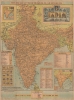
1960 Tej Brothers Tourist Road Map of India

This item has been sold.
India. Seeing India Made Easy Through this Road, Rail, Sea, and Air Route Map Guide.
Travel India!
Choose a Collection:
This Item
Enquire
Travel India!
This is a c. 1960 Tej Brothers tourist road map of India.A Closer Look
Depicting the entirety of India, the subcontinent's major road network appears in detail, along with minor roads and railroads. Pictorial icons mark lakes and forts. Pictorial mountains highlight the Himalayas. Insets detail India's states, as well as air and sea routes. Tables provide distances (in miles) from Bombay, Calcutta, Delhi, and Madras to other major cities, and another table lists 'interesting fact and figures'. A pictorial title cartouche blending Indian culture with airplanes, trains, and ships, appears in the upper right.Publication History and Census
This map was created and published by Tej Brothers c. 1960. This map does not appear in OCLC, and this is the only known cataloged example.Condition
Good. Backed on archival tissue for stability. Wear along original fold lines. Small areas of infill. Small areas of loss.