This item has been sold, but you can get on the Waitlist to be notified if another example becomes available, or purchase a digital scan.
1893 Ravenstein Map of the Arctic
SixPolarCharts-ravenstein-1893$125.00

Title
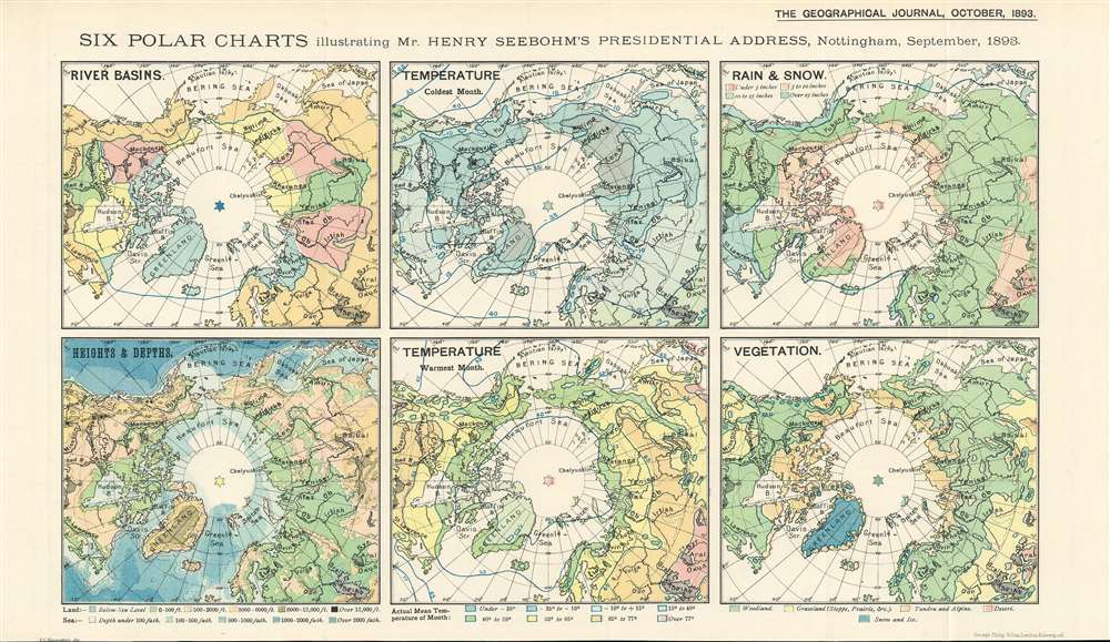
Six Polar Charts illustrating Mr. Henry Seebohm's Presidential Address, Nottingham, September, 1893.
1893 (dated) 9.25 x 16 in (23.495 x 40.64 cm)
1893 (dated) 9.25 x 16 in (23.495 x 40.64 cm)
Description
This is an 1893 Ernst Georg Ravenstein map of the Arctic consisting of six small maps printed on one sheet created to help illustrate Mr. Henry Seebohm’s address to the Royal Geographical Society. Each map illustrates a different aspect of the Arctic Basin, with a map focusing on river basins, temperature (coldest month), rain and snow, heights and depths, temperature (coldest month), and vegetation. An incredible amount of detail is present on each map. For example, four different colors are used to illustrate variations in precipitation and temperature in three of the maps, while five colors are employed to highlight different vegetation zones. The map detailing heights and depths, which would more traditionally be referred to as a topographic map, very much resembles other maps within that genre.
Publication History and Census
This map was created by Ernst Georg Ravenstein, printed by George Philip and Son, and published by the Royal Geographical Society in the October 1893 edition of The Geographical Journal. Only one example is catalogued in the OCLC, and it is part of the institutional collection at The British Library.CartographerS
Ernst Georg Ravenstein (December 30, 1834 - March 13, 1913), also known as Ernest George was a German-English cartographer and geographer. Born in Frankfurt-am-Main, Germany, Ravenstein was the son of the German cartographer and publisher Friedrich August Ravenstein (1809 - 1881), founder of Ravenstein's Geographische Verlagsanstalt (1830 - 2001). Likely fleeing political instability in Germany, he emigrated to England in 1851 or 1852. Upon arrival he immediately became a pupil of Dr. August Heinrich Petermann, also a German exile in England. He subsequently became a naturalized British subject and worked in the topographical-statistical office of the British War Office from 1855 until 1875. He was a member of the Royal Statistical Society and the Royal Geographical Society, and held the position of Professor of Geography at Bedford College from 1882 - 1883. In 1902, the Royal Geographical Society awarded him the first Victoria Gold Medal. Ravenstien is best known for his groundbreaking 'Rules of Migration' a detailed study of human movement. After nearly 60 years abroad, Ravenstein returned to Germany, where he died on March 13, 1913 in Hofheim, just outside his native Frankfurt. Throughout Ernst's time in England, his younger brother Ludwig Ravenstein (1838 - 1915), ran the family business in Frankfurt. More by this mapmaker...
Royal Geographical Society (fl. 1830 - present) is a British Society established in 1830 to promote geographical science and exploration. Originally titled the "Geographical Society of London", the RGS received its royal charter from Queen Victoria in 1859 shortly after absorbing several similar but more regional societies including the African Association, the Raleigh Club and the Palestine Association. The RGS sponsored many of the most important and exciting voyages of exploration ever undertaken, including the exploration of Charles Darwin, David Livingstone, Robert Falcon Scott, Richard F. Burton, John Speke, George Hayward, H. M Stanley, Ernest Shackleton and Sir Edmond Hillary. Today, the RGS remains a leading global sponsor of geographical and scientific studies. The Society is based in Lowther Lodge, South Kensington, London. Learn More...
George Philip (1800 - 1882) was a map publisher and cartographer active in the mid to late-19th century. Philip was born into a Calvinst family in Huntly, Aberdeenshire, Scotland. Around 1819 he apprenticed himself to William Grapel, a Liverpool printer and bookseller. Fifteen years later, in 1834, Philip founded his own Liverpool book and map firm. Philip's earliest cartographic ventures were mostly educational material issued in tandem with John Bartholomew Sr., August Petermann, and William Hughes. In 1848, Philip admitted his son, George Philip Jr. (1823 - 1902) into the firm, renaming it George Philip and Son Ltd. George Philip Jr. ran the firm until his death in 1902, by which time it had developed into a major publishing concern. His successors established the London Geographical Institute, a factory where they embraced modern printing techniques to produce thousands of economical and high quality maps. In April 1988, George Philip & Son was acquired by Octopus Publishing, a branch of Reed International. Nonetheless, today the firm trades and publishes to this day as George Philip and Son. Learn More...
Source
Royal Geographical Society, The Geographical Journal. (London: Royal Geographical Society) October 1893.
Condition
Very good. Light wear and toning along original fold lines. Blank on verso.
References
OCLC 556396641.