
1646 Robert Dudley Chart of the Indian Ocean and the East Indies: Rare First State

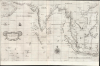

Carta prima Generale dell' Asia.
The first English Printed Nautical Chart to the Indies.
- Digital Map Information
- Suitable for large format printing
- File Size: 28.34 MB
- File Type: ZIP / TIFF
- ICC color profile embedded
- Delivered instantly via download link
The first English Printed Nautical Chart to the Indies.
This is a superb, first-state example of Robert Dudley's 1646 general nautical map of South Asia, from the Arabian Peninsula to the Philippines, including the coastlines of India, the Malay Peninsula, Cochinchina, and southern China. Countless islands of the Indian Ocean are charted, as are the western parts of the East Indies. It is the first printed chart of the route to the Spice Islands produced by an Englishman; it is the first to utilize the Mercator Projection, and the first to show prevailing winds, currents, and magnetic variation. The chart's portolan-like lines suggest its origin in the manuscript charts that informed it. Aesthetically, they distinguish this chart as one of the most elegant works dedicated to the region. It is a rarity on the market and a prize map for collectors.A Closer Look
This north-oriented chart presents the Indian Ocean, Bay of Bengal, and part of the East Indies from 27 degrees north to about 12 degrees south latitude; this band embraces most of the Persian Gulf from as far west as the vicinity of Bahrain (an island appears there, unnamed). The coasts of Persia, India, Bangladesh, Burma, Thailand, Vietnam, and part of China are delineated. In addition to the charted islands of the Indian Ocean, the chart includes Sumatra, Borneo, Java, and part of Celebes. While Dudley produced more narrowly-focused and detailed charts of specific areas within the coverage of the present work, the general charts such as this were among the first charts actually executed for the 1646 first volume of Dell' Arcano Del Mare; the Carti Partocolari for this region mostly appeared in volume 3 of the work, published the following year. Thus, this is the first of Dudley's charts to present the areas appearing here, such as Southern China and Vietnam. Its treatment of these areas is distinctive: note in particular the absence of Hainan Island, and the large lake emptying into the Golfo di Cochincina.Dudley's Sources
Dudley was a well-informed mapmaker. He was keen to draw on new sources wherever he could glean them. He himself crossed the Atlantic, and his charts of Guiana and the West Indies may have benefited from his own observation. While some of his charts drew heavily on Dutch sources, In this case, Dudley's main references were English: the manuscript works of the Thames School of chartmakers, whose masters are today known only by their names and their works. Even the dates of the founder of this tradition, John Daniell, are not known. Many of the details apparent on this chart compare closely to features found on Daniell's 1637 manuscript Carta nautica dell'arcipelago dell'India Orientale. Similarly, there are many points of correspondence between Dudley's treatment of the Indian Ocean coastlines and that to be found on Daniell's 1637 Carta nautica dell'Oceano Indiano. Both of these portolan charts survive in the archives of the Biblioteca Nazionale Centrale di Firenze, and they were very credibly Dudley's sources for his Carta Prima Generale dell'Asia. A quick comparison of the form of Borneo found on Daniell's relevant chart, with that which appeared on contemporaneous Dutch charts, will swiftly dismiss any notion of this chart having been copied from the Dutch. It must be said that this does not speak well for the utility of the present work: the inaccuracies of Daniell's charts - and the difficulty of interpreting their novel projection - were the source of numerous mariners' complaints: Thomas Bonner in 1616 made this complaint about Daniel's charts on a voyage to the East Indies. 'When off the coast of Sumatra, he says:By our plats which [were made by] John Danyell we were 90 leags short: but by an ould plat which we had in our ship of Cabrell Tattons makinge our reckninge fell out very perfit: I wonder John Danyell hath no better direktions. (Tyacke, p. 1744)
Publication History and Census
This map was completed by Sir Robert Dudley in manuscript form; it was subsequently engraved in an Italian baroque style by Antonio Francesco Lucini and printed in Florence in 1646, for inclusion in the first edition of Dudley's Dell'Arcano Del Mare. The present first-state example is easily distinguished from the 1661 state, which exhibits the notation 'Lº.2º.' in the cartouche.Rare. We see the separate chart in this state in only the State Library of New South Wales and Stanford University. Complete or partial examples of the Dell'Arcano Del Mare are more widely distributed among institutional libraries, though still quite rare.
Cartographer
Sir Robert Dudley (August 7, 1573 - September 6, 1649) was an English explorer and cartographer, the publisher of the Dell’Arcano de Mare, one of the greatest nautical atlases of all time. He was the illegitimate son of Robert Dudley, 1st Earl of Leicester (a favorite of Queen Elizabeth I) and Douglas Sheffield, the widow of John Sheffield, 2nd Baron Sheffield. In 1594, Dudley led an expedition across the Atlantic, with the intent of harassing Spanish merchantmen. His expedition met with a series of misfortunes, but successfully returned to England the following year. In 1596, Dudley joined an expedition led by Robert Devereux, 2nd Earl of Essex, against Cadiz. He served as the commander of the Nonpareil, and was knighted for his conduct in the capture of Cadiz. In 1603, Dudley made an attempt to establish his legitimacy at court and gain several inheritances, after being (possibly erroneously) informed that his parents had been secretly married. No concrete proof of the marriage could be furnished, thus the judgement was handed down against him in May 1605. Dudley left England in July of the same year, with his lover and cousin Elizabeth Southwell, who was disguised as his page. They married in Lyon in 1606 having received a papal dispensation. The couple settled in Florence, where Dudley began using his father’s title, Earl of Leicester, and his uncle’s, Earl of Warwick. In Florence, Dudley designed and built warships for the arsenal at Livorno and became a naval advisor to Ferdinand I, Grand Duke of Tuscany. In 1607, James I revoked Dudley’s travel license once ordered that he return to provide for his deserted wife and family. Dudley refused, was subsequently labeled an outlaw, and his estate was confiscated. By far Dudley’s most important work was the Dell’Arcano del Mare (Secrets of the Sea). His most celebrated achievement, is the atlas of sea charts of the world which accompanied the work. This maritime atlas was the first nautical atlas of the entire world in print, the first made by an Englishman, the first to show prevailing winds and currents, and the first to use the Mercator projection throughout. Further Details...
Source
Dudley, R., Dell'Arcano del Mare, (Florence: Francesco Onofri) 1647.
Condition
Excellent. Upper margin trimmed to neatline, else fine.
References
OCLC 893480966. Tyacke, S., 'Chartmaking in England and Its Context, 1500–1660', in The History of Cartography, Volume 3: Cartography in the European Renaissance, Part 2, (Chicago: University of Chicago Press) 2007.