
1646 Robert Dudley Chart of the Indian Ocean and the East Indies: Rare First State

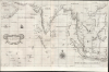

Carta prima Generale dell' Asia.
第一幅英國印製的印度洋海圖。
- Digital Map Information
- Suitable for large format printing
- File Size: 28.34 MB
- File Type: ZIP / TIFF
- ICC color profile embedded
- Delivered instantly via download link
第一幅英國印製的印度洋海圖。
這是一幅保存完好的羅伯特·達德利 (Robert Dudley) 於 1646 年繪製的南亞航海圖,涵蓋範圍從阿拉伯半島到菲律賓,包括印度、馬來半島、交趾支那和中國南部的海岸線。印度洋上無數島嶼以及東印度群島西部都被繪製在地圖上。它是英國人繪製的第一幅通往香料群島的印刷海圖;也是第一幅採用墨卡托投影法的海圖,並且第一幅標示了盛行風、洋流和磁偏角的海圖。海圖上類似航海圖的線條顯示其源自於手稿海圖。從美學角度來看,這些線條使這張海圖成為該地區最精美的作品之一。它在市場上極為罕見,是收藏家夢寐以求的珍品。仔細觀察
這張以北為導向的海圖描繪了印度洋、孟加拉灣以及東印度群島的部分地區,緯度範圍從北緯27度到南緯約12度;這一區域涵蓋了波斯灣的大部分地區,西至巴林附近(圖中顯示了一個未命名的島嶼)。波斯、印度、孟加拉、緬甸、泰國、越南以及中國部分地區的海岸線均標示。除了印度洋的島嶼之外,海圖還包括蘇門答臘島、婆羅洲、爪哇島以及蘇拉威西島的部分地區。雖然達德利繪製了更多針對特定區域的精細海圖,但像這樣的綜合海圖卻是最早為1646年出版的《海洋奧秘》(Dell' Arcano Del Mare)第一卷繪製的海圖之一;該區域的海圖大多出現在次年出版的第三卷中。因此,這是達德利繪製的首張包含此處所示區域(例如中國南方和越南)的海圖。它對這些地區的處理方式很獨特:尤其要注意海南島的缺失,以及流入科欽奇納灣的大湖的缺失。達德利的資料來源
達德利是一位博學的地圖繪製者。他熱衷於盡可能地利用新的資料。他本人曾橫渡大西洋,他繪製的圭亞那和西印度群島海圖或許得益於他自身的觀察。雖然他的一些海圖大量借鑒了荷蘭的資料,但在這張海圖上,達德利的主要參考資料卻是英國的:泰晤士河學派海圖繪製者的手稿。如今,這些大師的名字和作品已鮮為人知。甚至連這項傳統的創始人約翰·丹尼爾的生卒年月也無從考證。這張海圖上的許多細節與丹尼爾1637年的手稿《東方群島航海圖》(Carta nautica dell'arcipelago dell'India Orientale)中的特徵非常相似。同樣,達德利對印度洋海岸線的處理方式也與丹尼爾1637年的《印度洋航海圖》( Carta nautica dell'Oceano Indiano)的描述有許多相似之處。這兩幅航海圖都保存在佛羅倫斯國家中央圖書館的檔案館中,它們極有可能是達德利繪製《亞洲第一總圖》(Carta Prima Generale dell'Asia)的參考資料。只需將丹尼爾相關海圖上的婆羅洲形狀與同時期荷蘭海圖上的婆羅洲形狀進行快速比較,便可迅速否定該海圖抄襲自荷蘭海圖的任何說法。必須指出的是,這並非該海圖的實用性之高:丹尼爾海圖的不準確性——以及其新穎的投影方式難以解讀——曾引起眾多航海家的抱怨:托馬斯·邦納在1616年的一次東印度群島航行中就曾抱怨過丹尼爾的海圖。 “當他航行到蘇門答臘海岸附近時,他說:”根據約翰·丹尼爾繪製的圖紙,我們少了90里格;但根據我們船上卡布雷爾·塔頓繪製的舊圖紙,我們的計算結果卻非常準確。我真不明白約翰·丹尼爾為什麼沒有更好的圖紙。 (泰克,頁1744)
出版歷史和人口普查
這張地圖由羅伯特·達德利爵士以手稿形式完成;隨後由安東尼奧·弗朗切斯科·盧奇尼以意大利巴洛克風格雕刻,並於1646年在佛羅倫薩印刷,收錄於達德利的《海洋奧秘》(Dell'Arcano Del Mare)第一版中。現存的第一版與1661年的版本很容易區分,後者在地圖的裝飾框中帶有「Lº.2º.」的標記。罕見。目前僅在新南威爾斯州立圖書館和史丹佛大學見過這種狀態的獨立海圖。完整的或部分《海洋秘儀》 (Dell'Arcano Del Mare)在機構圖書館中分佈較為廣泛,但仍十分罕見。
Cartographer
Sir Robert Dudley (August 7, 1573 - September 6, 1649) was an English explorer and cartographer, the publisher of the Dell’Arcano de Mare, one of the greatest nautical atlases of all time. He was the illegitimate son of Robert Dudley, 1st Earl of Leicester (a favorite of Queen Elizabeth I) and Douglas Sheffield, the widow of John Sheffield, 2nd Baron Sheffield. In 1594, Dudley led an expedition across the Atlantic, with the intent of harassing Spanish merchantmen. His expedition met with a series of misfortunes, but successfully returned to England the following year. In 1596, Dudley joined an expedition led by Robert Devereux, 2nd Earl of Essex, against Cadiz. He served as the commander of the Nonpareil, and was knighted for his conduct in the capture of Cadiz. In 1603, Dudley made an attempt to establish his legitimacy at court and gain several inheritances, after being (possibly erroneously) informed that his parents had been secretly married. No concrete proof of the marriage could be furnished, thus the judgement was handed down against him in May 1605. Dudley left England in July of the same year, with his lover and cousin Elizabeth Southwell, who was disguised as his page. They married in Lyon in 1606 having received a papal dispensation. The couple settled in Florence, where Dudley began using his father’s title, Earl of Leicester, and his uncle’s, Earl of Warwick. In Florence, Dudley designed and built warships for the arsenal at Livorno and became a naval advisor to Ferdinand I, Grand Duke of Tuscany. In 1607, James I revoked Dudley’s travel license once ordered that he return to provide for his deserted wife and family. Dudley refused, was subsequently labeled an outlaw, and his estate was confiscated. By far Dudley’s most important work was the Dell’Arcano del Mare (Secrets of the Sea). His most celebrated achievement, is the atlas of sea charts of the world which accompanied the work. This maritime atlas was the first nautical atlas of the entire world in print, the first made by an Englishman, the first to show prevailing winds and currents, and the first to use the Mercator projection throughout. Further Details...
Source
Dudley, R., Dell'Arcano del Mare, (Florence: Francesco Onofri) 1647.
Condition
Excellent. Upper margin trimmed to neatline, else fine.
References
OCLC 893480966. Tyacke, S., 'Chartmaking in England and Its Context, 1500–1660', in The History of Cartography, Volume 3: Cartography in the European Renaissance, Part 2, (Chicago: University of Chicago Press) 2007.