This item has been sold, but you can get on the Waitlist to be notified if another example becomes available, or purchase a digital scan.
1873 Major / Weller Map of Southwest Greenland, Norse Settlements
SWGreenland-murray-1873$150.00

Title
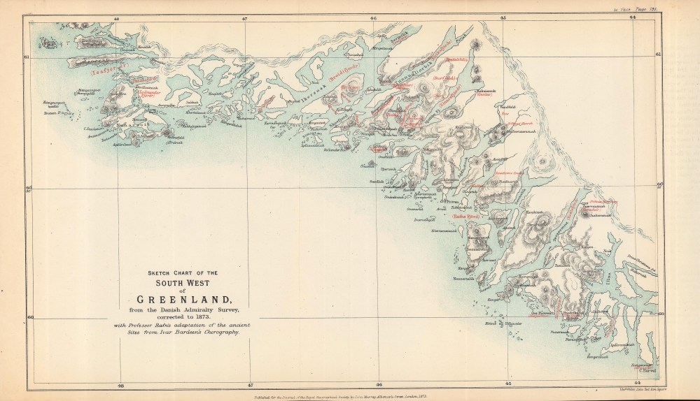
Sketch chart of the south west of Greenland from the Danish Admiralty Survey, corrected to 1873, with Professor Rafn's adaptation of the ancient sites from Ivar Bardsen's chorography.
1873 (dated) 7.75 x 13 in (19.685 x 33.02 cm) 1 : 1700000
1873 (dated) 7.75 x 13 in (19.685 x 33.02 cm) 1 : 1700000
Description
A fascinating 1873 map of the southwest coast of Greenland, lithographed by Edward Weller for the Journal of the Royal Geographical Society, published by John Murray. It accompanied an article by Richard Henry Major, one of the journal's editors, which argued for two instances of pre-Columbian discovery of the Americas, one (later debunked) by the Venetian Zeno Brothers in the 14th century, and one by the Norse settlers of Greenland, later corroborated.
This map is independently cataloged among the holdings of Princeton University and is scarce to the market, while the entire 1873 volume of the Journal of the Royal Geographical Society and, to a lesser extent, the booklet published by the Hakluyt Society, are well-represented in the holdings of major research institutions.
A Closer Look
Coverage stretches from just north of the island of Nunarsoit (Nunarsuit) south to the area around Fredriksdal (Narsarmijit) on the southwestern coast of Greenland, highlighting islands, fjords, and settlements. Major applies the terminology of Carl Christian Rafn, a 19th century Danish scholar of Old Norse cultures, to note the ancient names of places in red (Rafn derived these names from Ivar Bårdsson, a cleric sent to Greenland in the 1340s who recorded sailing directions). The ancient and modern place names are overlaid on a map drawn from an 1873 Danish Admiralty Survey chart.Norse Greenland and the European Discovery of America
These coasts spanned the two main Norse settlements on Greenland (known as the Eastern and Western Settlement, though their relative orientation was more so south and north), which lasted from the late 10th to the 15th century CE. Erik the Red was likely the founder of the colonies, which included farms, workshops, and churches. His son, Leif Erikson, set out from these lands to explore the area known to the Norse as Vinland, accepted to be Newfoundland, where archaeological remains were discovered in 1960 at l'Anse aux Meadows. Though brief and likely only seasonal, the Norse settlement at Vinland demonstrates a European presence in the Americas centuries before Columbus.Zeno Brothers
Aside from the Norse on Greenland, Major also argued for the discovery of the Americas in the 14th century by the Venetian traders Nicolo and Antonio Zeno. In 1558, a descendant of the brothers published a map and several letters indicating that they had discovered several previously unknown islands in the North Atlantic, including one roughly at the location of Labrador. These islands were then incorporated into the atlases of leading map publishers in Europe. The Zeno cartography was persistent, but over time, unable to be located by navigators, they gradually fell off maps in the 18th century (the most persistent was 'Frisland,' often thought to be the Orkney or Faroe Islands). Eventually, they were deemed 'phantom islands,' but many historians and scholars, including Major, continued to believe that the Zeno Brothers had reached the Americas. It was only in 1898 that F. W. Lucas proved the Zeno map and letters to be a fabrication, though the 'Zeno myth' persisted even well into the 20th century.Publication History and Census
This map was drafted by Edward Weller and published by the firm John Murray. It appeared in 1873 in Volume 43 of the Journal of the Royal Geographical Society, accompanying Richard Henry Major's article 'The Site of the Lost Colony of Greenland Determined, and Pre-Columbian Discoveries of America Confirmed, from 14th Century Documents.' Major was an editor of the Journal of the Royal Geographical Society and Secretary of the Royal Geographical Society. The article summarizes a short book by Major (published by the Hakluyt Society the same year), which also included the map, titled The Voyages of the Venetian Brothers, Nicolò and Antonio Zeno, to the Northern Seas in the XIVth Century: Comprising the Latest Known Accounts of the Lost Colony of Greenland and of the Northmen in America Before Columbus.This map is independently cataloged among the holdings of Princeton University and is scarce to the market, while the entire 1873 volume of the Journal of the Royal Geographical Society and, to a lesser extent, the booklet published by the Hakluyt Society, are well-represented in the holdings of major research institutions.
CartographerS
John Murray I (1737 - 1793) founded the British publishing firm John Murray (1768 - present) in London. Born in Edinburgh, Murray served as an officer in the Royal Marines and built a list of authors that included Isaac D’Israeli and published the English Review. Murray the elder also was one of the founding sponsors of the London evening newspaper The Star in 1788. John Murray II (November 27 1778 - June 27, 1843) continued the family publishing business and developed it into one of the most important and influential publishing houses in Britain. The list of authors published by the firm grew to include Jane Austen, Sir Walter Scott, Washington Irving, George Crabbe, and Lord Byron under his tenure. Murray II also moved the business to 50 Albermarle Street in Mayfair, which became famous for Murray’s tradition of ‘four o’clock friends’, which was afternoon tea with his writers. John Murray III (1808 - 1892) continued to grow the business, and the firm published the first English translation of Goethe’s Theory of Colours, David Livingstone’s Missionary Travels and Charles Darwin’s Origin of Species during his tenure. Murray also published Herman Melville’s first two books. The firm began publishing Murray Handbooks in 1836, an ancestor of all modern travel guides. Sir John Murray IV (1851 - 1928) was publisher to Queen Victoria. Three successive Murray’s after Murray IV led the business until it was purchased by Hodder Headline in 2002, which was acquired by the French conglomerate Lagardère Group in 2004. Today, Murray is an imprint of Lagardère under the imprint Hachette UK. More by this mapmaker...
Edward Weller (July 1, 1819 - 1884) was a cartographer and engraver based in London. Weller was a nephew of another well-known map publisher Sidney Hall (1788 - 1831), who gave him 50 Pounds to pay his apprenticeship fees. He engraved for many prominent mapmakers and was active enough in the community to be recommended for membership to the Royal Geographical Society in 1851 on the recommendation of John Arrowsmith, among others. He eventually inherited the Sidney Hall map business which led him to follow Arrowsmith as the unofficial geographer to the Royal Geographical Society. Weller was among the first map printers in London to embrace lithography. His best known work appears in Cassell's Weekly Dispatch Atlas, published in monthly segments for subscribers of the 'Weekly Dispatch' newspaper. This collection of maps eventually grew to include much of the known world. Published in various editions from 1855 through the early 1880s. Weller died in May of 1884, leaving behind a successful business and an unhappy widow. His son, Francis Sidney Weller (1849 - 1910), followed in his father's footsteps and continued the family map business. The atlas Mackenzie's Comprehensive Gazetteer of England and Wales was published in 1894 and bore F. S. Weller's signature on the maps. Learn More...
Royal Geographical Society (fl. 1830 - present) is a British Society established in 1830 to promote geographical science and exploration. Originally titled the "Geographical Society of London", the RGS received its royal charter from Queen Victoria in 1859 shortly after absorbing several similar but more regional societies including the African Association, the Raleigh Club and the Palestine Association. The RGS sponsored many of the most important and exciting voyages of exploration ever undertaken, including the exploration of Charles Darwin, David Livingstone, Robert Falcon Scott, Richard F. Burton, John Speke, George Hayward, H. M Stanley, Ernest Shackleton and Sir Edmond Hillary. Today, the RGS remains a leading global sponsor of geographical and scientific studies. The Society is based in Lowther Lodge, South Kensington, London. Learn More...
Source
Major, R.H., 'The Site of the Lost Colony of Greenland Determined, and Pre-Columbian Discoveries of America Confirmed, from 14th Century Documents' in Journal of the Royal Geographical Society, (London: John Murray) 1873.
Condition
Very good. Slight creasing along the fold lines.
References
OCLC 1340338183.