
1891 Imray Nautical Chart / Map of Tasmania, Australia

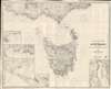

South and East Coasts of Australia [In Five Charts] Chart No. 2, Cape Northumberland to Cape Howe.
Sailing to Tasmania!
- Digital Map Information
- Suitable for large format printing
- File Size: 75.25 MB
- File Type: ZIP / TIFF
- ICC color profile embedded
- Delivered instantly via download link
Sailing to Tasmania!
A striking 1883 James Imray and Son blueback nautical chart or maritime map of Tasmania, Australia. The map captures a transition period as Tasmania emerged from its convict era to embrace mining and agriculture.A Closer Look
Centered on Tasmania, this chart extends north to include Melbourne, west to South Australia, and East to Cape Howe. Insets detail Hobart, Port Dalrymple, Port Phillip, Port Western, Portland, Belfast, and Lady Bay. As expected of a nautical chart, the map features copious depth soundings, excellent annotations regarding lights and buoys, and other practical information for the mariner. In addition, the map illustrates the region's fledgling railroad network, including the Melbourne Geelong and Ballarat Railway, running between Geelong and Melbourne. An official pastedown, issued by Imray on October 10, 1890, adds additional instructions for navigating Bass Strait.Historical Context
When this map was made Tasmania was a small but developing British colony marked by a transition from its penal past to a more diversified economy and society. The convict era had formally ended decades earlier, and the island was working to redefine itself through agriculture, mining, and trade. The west coast saw the beginnings of a mining boom, particularly in tin and gold, which would intensify later in the decade. Hobart and Launceston, the main urban centers, experienced modest growth, with new public buildings, improved infrastructure, and increasing civic organization. Tasmania's isolation from mainland Australia fostered a distinct cultural identity, even as debates about federation and economic integration with the other colonies began to emerge.Blueback Charts
Blueback nautical charts began appearing in London in the late 18th century. Bluebacks, as they came to be called, were privately published large format nautical charts known for their distinctive blue paper backing. The backing, a commonly available blue manila paper traditionally used by publishers to wrap unbound pamphlets, was adopted as a practical way to reinforce the low-quality paper used by private chart publishers in an effort to cut costs. That being said, not all blueback charts are literally backed with blue paper. The earliest known blueback charts include a 1760 chart issued by Mount and Page and a 1787 chart issued by Robert Sayer. The tradition took off in the early 19th century, when British publishers like John Hamilton Moore, Robert Blachford, James Imray, William Heather, John William Norie, Charles Wilson, David Steel, R. H. Laurie, and John Hobbs, among others, rose to dominate the chart trade. Bluebacks became so popular that the convention was embraced by chartmakers outside of England, including Americans Edmund March Blunt and George Eldridge, as well as Scandinavian, French, German, Russian, and Spanish chartmakers. Blueback charts remained popular until the late 19th century, when government-subsidized organizations like the British Admiralty Hydrographic Office and the United States Coast Survey began issuing their own superior charts on high-quality paper that did not require reinforcement.Publication History and Census
This map was first issued by Imray and Son in 1883. It is part 2 in a series of five charts illustrating the southern and eastern coasts of Australia. The map went through numerous subsequent editions, with the present edition bearing updates to 1891.Cartographer
James Imray (May 16, 1803 - November 15, 1870) was a Scottish hydrographer and stationer active in London during the middle to latter part of the 19th century. Imray is best known as the largest and most prominent producer of blue-back charts, a type of nautical chart popular from about 1750 to 1920 and named for its distinctive blue paper backing (although not all charts called "blue-backs" actually have a blue backing). Unlike government charts issued by the British Admiralty, the U.S. Coast Survey, and other similar organizations, Imray's charts were a private, profit-based venture. They were not generally the result of unique survey work. Rather, Imray's charts were judicious and beautiful composites based on pre-existing charts (some dating to the 17th century) and new information gleaned from governmental and commercial pilots and navigators. Imray was born in Spitalfields, England, the eldest son of a Jacobite dyer also named James. Imray did not follow his father's profession; instead, he apprenticed to William Lukyn, a stationer. He established himself as a bookseller and bookbinder at 116 Minories Street, where he shared offices with the nautical chart publisher Robert Blanchford (1775 - c. 1852). In 1836, Imray signed on as a full partner in Blanchford's enterprise, christening themselves Blanchford & Imray. At the time, the Blanchford firm lagged far behind competing chart publishers Norie and Laurie; nevertheless, with the injection of Imray's marketing savvy, the firm began a long rise. James Imray bought out Blanchford's share in 1846, becoming the sole proprietor of the chart house, publishing under the imprint of James Imray. Relocating in 1850 to larger offices at 102 Minories, Imray was well on track to become the most prominent chart publisher in London. In 1854, when Imray's 25-year-old son, James Frederick Imray, joined as a full partner, the firm again changed its imprint, this time to James Imray and Son. The elder Imray was a master of marketing and quick to respond to shifts in trade and historical events. Many of his most successful charts were targeted at specific trade routes; for example, he issued charts titled "Cotton Ports of Georgia" and "Rice Ports of India". Other charts emerged quickly following such events as the 1849 California Gold Rush. Imray's rise also coincided with the development of governmental mapping organizations such as the Admiralty and the U.S. Coast Survey, whose work he appropriated and rebranded in practical format familiar to navigators. Imray's death in 1870 marked a major transition in the firm's output and the beginning of its decline. Though Imray's son, James Frederick, excelled at authoring pilot books, he had little experience with charts and issued few new publications. Most James Frederick Imray publications issued from 1870 to 1899 were either revisions of earlier maps prepared by his father or copies of British Admiralty charts. Charts from this period are recognizable as less decorative than the elder Imray's charts, which follow the stylistic conventions established by the Admiralty. The Admiralty itself at the same time began to rise in prominence, issuing its own official charts that were both cheaper and more up to date than those offered by private enterprises. By the end of the century, the firm was in decline, and in 1899, "James Imray and Son" amalgamated with the similarly suffering "Norie and Wilson", which was itself acquired by Laurie in 1904. Today, it continues to publish maritime charts as "Imray, Laurie, Norie and Wilson". Further Details...
Condition
Very good. Light soiling.