
1931 Spanish Army Map of Tenerife, Canary Islands

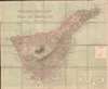
Isla de Tenerife.
Best and largest map of Tenerife to appear during the Second Spanish Republic.
- Digital Map Information
- Suitable for large format printing
- Full resolution TIFF file
- ICC color profile embedded
- Delivered instantly via download link
Best and largest map of Tenerife to appear during the Second Spanish Republic.
This is a c. 1931 Spanish Depósito Geográfico e Histórico del Ejército large-scale map of Tenerife, Canary Islands. It is the largest and most detailed map of Tenerife to appear during the Second Spanish Republic. Tenerife is the largest and most populated of the Canary Islands. While it is now a popular tourist destination, historically, Tenerife was a crucial stopping point on trans-Atlantic voyages.A Closer Look
Coverage embraces the entire island with molecular detail. Towns, points, beaches, and other coastal features are identified, along with rivers and mountain peaks. Transportation networks, including highways, roads, and tram lines, are also noted.The Second Spanish Republic
Per the Biblioteca Nacional de España, this map was published in 1931, the year King Alfonso XIII was deposed and the Second Spanish Republic declared. This map was likely created for the newly declared Republic. The Second Spanish Republic suffered insurgencies and unrest from its inception, ultimately losing the Spanish Civil War to the Nationalist regime of Francisco Franco. Tenerife fell to the Nationalists in 1936.Publication History and Census
This map was created and published by the Depósito Geográfico e Histórico del Ejército c. 1931. Three examples are cataloged in OCLC and are part of the institutional collections at Biblioteca Nacional de España, the Consejo Superior Investigaciones Cientificas, and the British Library.Cartographer
Depósito Geográfico e Histórico del Ejército (1931 - 1939) was an organization within the Spanish army. Very little information about this specific organization is available. But, from our research, it appears that the Depósito Geográfico e Histórico del Ejército was created after the Depósito de la Guerra was dissolved in 1931 and fell under the jurisdiction of the Spanish General Staff. It also appears that the Depósito Geográfico e Histórico del Ejército disappeared in 1939 after the end of the Spanish Civil War, when Franco reorganized the Ministry of War and created the Servicio Geográfico del Ejército. Further Details...
Condition
Very good. Dissected and mounted on linen in 20 panels. Some light soiling. Accompanied by original binder.
References
OCLC 431310638.