
1522 / 1541 Waldseemüller / Fries Map of the New World

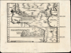
[Tabula terrae novae]
One of the Earliest maps to name America.
- Digital Map Information
- Suitable for large format printing
- Full resolution TIFF file
- ICC color profile embedded
- Delivered instantly via download link
One of the Earliest maps to name America.
A cartographic landmark, this is Lorenz Fries' edition of the first separate, printed map of America. First printed in 1522, it succeeds and synthesizes Martin Waldseemüller's 1513 Tabula Terre Nove and his 1516 Carta Marina. No improved, acquirable map of this part of the world appeared until Münster's 1540 map of the Americas.A Closer Look
This distinctive woodcut map is centered on the Atlantic Ocean, and thus presents the newly discovered Americas in context with the shores of the old world. The eastern part of the map shows the rudimentary coasts of England, France, and Spain; and the northwestern part of Africa, with a particular focus on Cape Verde. The Cape Verde Islands, the Canaries, and the Azores are included, highlighting their importance as stepping-stones to the west. The phantom island of Brazil appears to the west of England.To the west appear the Americas, and a recognizably rendered West Indies (Cuba, here named Isabella, is marked with the flag of Spain). Florida and the Gulf of Mexico appear in an embryonic form. A text block describes the discovery of these lands and credits Columbus.
North America is shown as a contiguous landmass with Terra Firma and Brazil, whose coastline is traced to the southern limit of the map, 40 degrees south. The text credits Columbus again, but it also paraphrases Vespucci in its description of the region's cannibalistic denizens. That text is reinforced by a lively woodcut cannibal scene, and a depiction of a fearsome opossum. The map's geographical features are closely copied from Waldseemüller's 1513 Tabula Terre Nove; the pictorial elements, including the Spanish Flag, derive instead from his 1516 Carta Marina.
The Sources
The 1513 Waldseemüller map upon which this is based has often been referred to as 'The Admiral's Map,' a term rooted in the implication that Columbus - 'the Admiral' - was the source of the atlas' New World cartography. Waldseemüller's more immediate cartographic source for the coastlines shown here appears to be the 1506 manuscript map of the Genoese Nicolay de Caveri (Caverio), or a similar work, whose influence can also be seen on Waldseemüller's 1513 maps of Africa and Southeast Asia.Waldseemüller's reliance on the Caverio map is most evident on his 1516 Carta Marina, whose American geography corresponds very closely to Waldseemüller's Tabula Terre Nove, the main source for Fries' map: this is important, because Fries drew directly not only on the 1513 map's geography but also on the Carta Marina's imagery. Fries was equally familiar with Waldseemüller's 1513 and 1516 works, having been tapped by the Strasbourg publisher Grüninger to produce new editions of both. As a result, Fries incorporated the visual information of the Carta Marina throughout the maps of his new edition of Waldseemüller's Ptolemy, as on this map.
A New World, or the Eastern Extreme of the Old?
Throughout the 16th century, geographers disagreed on whether the coastlines shown here were the shores of a new continent or the eastern limits of Asia. (The issue was not settled until Cook's voyages of the 18th century.) This map, depicting no western coastlines, made no statement on that topic. Waldseemüller's 1507 world map and the modern world map in his 1513 Ptolemy both implied a separation of the New World from Asia, but the geography of the present map, and its 1513 Waldseemüller precursor, does not resemble those maps. It is a very close match to the geography of the 1516 Carta Marina, and that map was completely unambiguous in presenting North America as part of Asia: the region termed Parias on the Fries map is, on the Carta Marina, Terra de Cuba, Asie Partis. While the Carta Marina leaves the specific connection between Asia and America uncertain, the map's language leaves no doubt that the two were somehow connected. It is worth noting, then, that Fries' iteration of this map removes all specific mentions of Asia and emphasizes the region as Terra Nova, suggesting that he believed the New World was separate from Asia. Fries's opinion was probably not reflected in the text on the back of the map, which contains a strongly worded rejection of using 'America' for the New World. This text appeared in neither the 1522 nor the 1525 editions of the map, and is likely an insertion by the editor of the 1535 and 1541 editions of the book, Michael Villanovus (Servetus). Fries' world map specifically named the New World 'America,' following the lead of Waldseemüller's 1507 map and the 1520 Apianus (a work in which Fries participated).Publication History and Census
This map was first issued in Strasbourg in the 1522 Grüninger edition of Ptolemy's Geographia. A further edition was produced in that same city and by the same publisher in 1525. Afterward, two further editions of 1535 and 1541 were published in Lyon and Vienne-in-the-Dauphane, respectively, both edited by Michael Villanovus (Servetus). This example conforms typographically to the 1541 edition. Overall, the four editions of Fries' Ptolemy are well represented in institutional collections, but scarce on the market, especilly in good condition.Cartographers
Lorenz Fries (c. 1490 – 1531) was a German cartographer, cosmographer, astrologer, and physician based in Strasbourg. Little is known of Fries' early life. He may have studied in Padua, Piacenza, Montpellier, and Vienna, but strong evidence of this is unfortunately lacking. The first recorded work of Fries was a 1513 Nuremberg broadside (announcing and describing the birth of a 'wonderous and terrifying monster' (Karrow). Fries settled in Strasbourg in March 1519, where he developed a long-standing relationship with the publisher Johann Grüninger. His time in Strasbourg makes it possible that he encountered and knew the St. Die scholars, but beyond the documented connection to the publisher, there is no concrete evidence that he knew them. Most importantly, while there is abundant and clear evidence that Fries was an intellectual successor of Martin Waldseemüller, having worked extensively with his cartographic legacy, there is no similar evidence to prove that the two worked together or even knew one another. On the other hand, from roughly 1520 to 1525, Fries did work closely with Grüninger as the geographic editor of various maps and atlases based upon Waldseemüller's work. He collaborated with Peter Apian in the production of their 1520 reissue of Waldseemüller's world map of 1507. Around this time, Fries also began working on Grüninger's reissue of Waldseemüller's 1513 edition of Ptolemy's Geographie Opus Novissima. That edition included three new maps by Fries based upon the Waldseemüller world map of 1507 – two of these, his maps of East Asia and Southeast Asia, are quite significant as the first specific maps of these regions issued by a European0 publisher. In 1525, Fries and Grüninger produced a new edition of Waldseemüller's Carta Marina, a project which plausibly could have predated Fries' Ptolemy, as many of the text notations included in Fries's 1522 work were paraphrased and sometimes quoted directly from Waldseemüller's 1516 map. 1525, Fries decided to leave Strasbourg and surrendered his citizenship, relocating to Trier. In 1528, he moved to Basel. Afterward, he relocated to Metz, where he most likely died. In addition to his cartographic work, Fries published tracts on medicine, religion, and astrology. Further Details...
Martin Waldseemüller (September 11, 1470 - March 16, 1520) was a German cartographer, astronomer, and mathematician credited with creating, along with Matthias Ringmann, the first map to use the placename America. He was born in Wolfenweiler, near Freiburg im Breisgau. Waldseemüller studied at the University of Freiburg and, on April 25, 1507, became a member of the Gymnasium Vosagese at Saint-Dié. Martin Waldseemüller was a major proponent of theoretical or additive cartography. Unlike contemporary Portuguese and Spanish cartographers, who left maps blank where knowledge was lacking, Waldseemüller and his peers speculated based upon geographical theories to fill unknown parts of the map. He is best known for his Universalis Cosmographia a massive 12-part wall map of the world considered the first map to contain the name America, today dubbed as 'America's Birth Certificate'. This map also had significance on other levels, as it combined two previously unassociated geographical styles: Ptolemaic Cartography, based on an ancient Greek model, and the emergent 'carta marina', a type of map commonly used by European mariners in the late 15th and 16th centuries. It also extended the traditional Ptolemaic model westward to include the newly discovered continent of America, which Waldseemüller named after the person he considered most influential in its discovery, Amerigo Vespucci. When Waldseemüller died in 1520, he was a canon of the collegiate Church of Saint-Dié. In contemporary references his name is often Latinized as Martinus Ilacomylus, Ilacomilus, or Hylacomylus. Further Details...
Michael Servetus (1509/11 - October 27, 1553), also known as Miguel Servet, Michel de Villeneuve, and Michael Villanovanus or Villanovus, was a Spanish physician, theologian, humanist, and geographical editor whose career united Renaissance scholarship with the religious controversies of the Reformation. He studied law at Toulouse before pursuing theological questions that brought him into conflict with both Catholic and Protestant authorities; his De Trinitatis Erroribus (1531) and Dialogorum de Trinitate (1532) challenged orthodox Trinitarian doctrine, prompting him to adopt the name Michel de Villeneuve and establish himself in France. Working with the Trechsel printing firm in Lyon, he edited the 1535 and 1541 editions of Ptolemy’s Geographia, the works through which his name is most familiar to map collectors. His geographical contribution was principally editorial: he revised the Latin text, supplied explanatory material, and compiled descriptions of countries and their inhabitants, drawing extensively on earlier authorities. These editions place him within the Renaissance effort to reconcile classical geographical learning with contemporary knowledge, although modern scholarship cautions against treating all his descriptive material as original. Peter Hughes, Michael Servetus's Britain. Servetus subsequently studied medicine in Paris, assisting the anatomist Johann Günther von Andernach, and eventually settled in Vienne as physician to Archbishop Pierre Palmier. His theological interests continued alongside his medical practice, culminating in Christianismi Restitutio (1553), which contained the first published European description of pulmonary circulation—the passage of blood from the right side of the heart through the lungs to the left. Publication exposed his concealed identity and led to his arrest by Catholic authorities in Vienne; after escaping imprisonment, he traveled to Geneva, where he was arrested again and prosecuted for heresy, with John Calvin playing a leading role in the proceedings. Condemned by Geneva’s council for his religious teachings, including his rejection of orthodox Trinitarian doctrine and infant baptism, Servetus was burned at the stake on October 27, 1553. His execution provoked an enduring controversy over religious persecution and helped make him a central figure in the history of freedom of conscience. Further Details...
Source
Fries, L., Claudii Ptolemaei Alexandrini Geographicae enarrationis libri octo, (Vienne in the Dauphane: Trechsel) 1541.
Condition
Very good. Few small wormholes. Marginal repair at top centerfold only slightly impacting image, with no loss.
References
OCLC 57232880 Rumsey 11325.060. Burden, P., The Mapping of North America, #4.