
1955 Chung Hwa / China Cartographic Map of Tibet

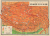
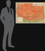
(中學適用)西藏區地形掛圖 / Topographic Wall Map of Tibet (for Use in Middle Schools).
Tibet between Independence and Incorporation.
Tibet between Independence and Incorporation.
This is a scarce c. 1955 Chinese wall map of Tibet printed by the Chunghwa (or Zhonghua) Book Company in Shanghai and published by the China Cartographic Publishing House in the wake of the October 1950 invasion of Tibet by the People's Liberation Army. It was ostensibly drawn for classroom use in middle schools (中學適用), but the map is part of a broader effort to generate support for Chinese sovereignty over Tibet and legitimize their claims.A Closer Look
The large-scale map covers the portion of Tibet under the control of the Dalai Lama's government in Lhasa (Ü-Tsang, the future Tibet Autonomous Region) as well as large parts of the Tibetan cultural regions of Kham (western Sichuan and environs) and Amdo (Qinghai). Portions of neighboring countries and territories (India, Nepal, Sikkim 錫金, Bhutan, Burma, and, in the bottom margin, East Pakistan) are also included. The map displays terrain (by color shading), cities, waterways, mountain passes, roads (including those under construction), railways, and administrative and international borders. Individual mountains are labeled with their elevations noted. Lhasa is marked with a red dot near the center-bottom, home to the 'Tibetan Local Government' (西藏地方政府), that is, the Dalai Lama's Government. A People's Liberation Committee is noted in Chamdo (昌都), site of the earliest engagements leading to the Chinese invasion of Tibet.An interesting note in the legend below the scale mentions that the administrative borders are based on a map published before the Second Sino-Japanese War (1937 - 1945) by the Shanghai newspaper and publishing house Shenbao (申報), augmented by more recent information. This is a reflection of the fact that, while Beijing had a significant presence in Tibet by this time, the plateau's vast expanses were still poorly mapped and understood in China proper.
This map unsurprisingly reflects Chinese territorial claims along the long-disputed border with India. The lack of good maps and uncertain jurisdiction led to tension over the Sino-Indian border and was a major factor in the Sino-Indian Border War of 1962, as well as other border clashes since the late 1940s. Here, two major roads are seen as under construction in the western part of Tibet, leading to Aksai Chin; when completed in the late 1950s, these formed the backbone of China's de facto regional sovereignty.
The Chinese Invasion of Tibet
For most of their histories, except for periods of active military campaigns, the Ming and Qing dynasties maintained a very loose rule over Tibet, a 'Priest-Patron' relationship that was closer to suzerainty than sovereignty. The Qing presence in Lhasa typically consisted of a handful of officials, the highest being the Amban ('High Commissioner'), and a small garrison of troops. However, in the late 19th century, the Qing belatedly recognized the threat of Russian and British incursions into Tibet, especially after the 1903-1904 Younghusband Expedition (i.e., invasion), and attempted to assert greater control over the Dalai Lama, including a punitive military expedition. Nonetheless, soon afterward (in 1911), the Qing Dynasty collapsed, and Tibet entered a period of de facto independence that would last nearly four decades.In 1912, the 13th Dalai Lama (r. 1895 - 1933) returned from exile in Darjeeling, expelled remaining Chinese troops and the Amban from Lhasa, and issued a proclamation reaffirming Tibet's independence. During this era, Tibet functioned as a sovereign state with its own government, currency, army, and postal system, although it struggled to gain formal recognition from the international community or to assert rule over diverse pastoralist herders and monasteries in far-flung areas, particularly in Amdo and Kham. The British, seeking a buffer state between India and China, convened the Simla Convention in 1914, attempting to mediate the border status between Tibet and China. While the British and Tibetan representatives agreed to the 'McMahon Line' border, the severely weakened Chinese Republican government refused to ratify the agreement, leaving the legal status of the region ambiguous and setting the stage for future conflict. Border fighting between Chinese warlord troops and Lhasa (such as the Sino-Tibetan War of 1930-1932) both confirmed Tibet's de facto independence and its still-undetermined status vis-à-vis the modern Chinese nation-state.
This effective stalemate was upended by the establishment of the People's Republic of China (PRC) in 1949. On the one hand, the Communists had long discussed the importance of granting ethnic minorities autonomy within a Chinese socialist framework, and Mao Zedong appears to have genuinely considered allowing Tibet to maintain its de facto independence. But the uncertainty of the international situation facing the new People's Government, especially as Mao leaned towards intervening militarily in Korea, led the PRC to declare its intention to 'liberate' Tibet from what it considered 'foreign imperialist forces'. In October 1950, the People's Liberation Army (PLA) launched a military offensive across the Jinsha River (金沙江, at right here), marking the start of the invasion. This campaign, known as the Battle of Chamdo, saw 40,000 battle-hardened PLA troops rapidly overwhelm the ill-equipped and outnumbered Tibetan army, which suffered a decisive defeat within weeks.
The military defeat at Chamdo forced the Tibetan government in Lhasa to negotiate with Beijing to avoid a full-scale conquest of the capital. In May 1951, a Tibetan delegation signed the 'Seventeen Point Agreement for the Peaceful Liberation of Tibet,' a document that formally recognized Chinese sovereignty over Tibet for the first time in exchange for promises of autonomy and the preservation of the Dalai Lama's political and religious status. A tense but functioning coexistence emerged between the Tibetan government in Lhasa and the Chinese Communist Party. For several years, Chinese authorities largely adhered to the agreement's terms in Central Tibet (Ü-Tsang), permitting the Dalai Lama to retain his domestic authority and delaying radical socialist reforms. The young 14th Dalai Lama (enthroned in 1940 as a child, with rule exercised by regents) even traveled to Beijing in 1954 to meet Mao, expressing cautious optimism about modernizing Tibet within the framework of the new Chinese state. Even as China proper moved gradually towards socialism (collectivization of agriculture and the elimination of private enterprises), Mao sent peaceful overtures, saying that it could be many decades before such reforms were attempted in Tibet. However, the CCP was simultaneously consolidating its military infrastructure across the plateau, building strategic roads and airfields that would eventually facilitate full control.
The turning point occurred not in Lhasa, but in the eastern regions of Kham and Amdo (parts of modern-day Sichuan and Qinghai provinces). These ethnically Tibetan areas were not under the Dalai Lama's direct authority and were therefore not protected by the Seventeen Point Agreement. In the mid-1950s, the CCP launched aggressive 'Democratic Reforms' in these regions, enforcing collectivization of agriculture, the sedentarization of nomads, attacking religious 'superstition,' and subjecting monasteries (which owned much of the land and herds) to 'struggle sessions.' These policies triggered a fierce armed resistance known as the Khampa Uprising in 1956, resulting in open warfare, including Chinese aircraft bombing monasteries. This violence created a massive refugee crisis, as thousands of displaced Khampas and Amdowas fled west to Lhasa, bringing with them harrowing accounts of the reforms that radicalized Lhasa's population. In the aftermath of the Khampa Uprising, Tibetan guerrilla units formed in Ü-Tsang (later receiving support from the American Central Intelligence Agency) and began attacking PLA troops, while the Dalai Lama was caught in the middle, futilely trying to maintain peace. Tensions culminated in March 1959, when rumors circulated that the PLA planned to abduct the Dalai Lama, which set off a mass uprising in Lhasa and throughout Ü-Tsang, leading to the Dalai Lama's flight to India and the subsequent dissolution of the Tibetan local government.
Not completely without justification, China interpreted the unrest in Lhasa as the result of schemes hatched in Washington, Taipei, and Delhi. Tensions with India rose to the point that the two countries fought a conflict over their disputed border in 1962. Not only did the border war mark a low point in relations between the two Asian giants, but Soviet support for India's position was one of the major causes of the Sino-Soviet Split, which redefined the Cold War.
Publication History and Census
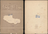
This map was printed by the Chunghwa (or Zhonghua) Book Company in Shanghai and published by the China Cartographic Publishing House. It is undated, but as mentioned above, the inclusion of a People's Liberation Committee in Chamdo indicates a date of October 1950 or later. The presence of the 'Xinjiang Uyghur Autonomous Region' (新疆維吾爾自治區) at the top suggests a date of 1955 or later, but other details, including the roads present and the retention of traditional characters over simplified, would mean that the map could not date to much later than 1955. The stamps on the cover of the map are somewhat faded, but are legible enough to indicate that this particular example was issued in Xi'an, most likely to a government office or library (Xi'an, meaning literally 'Western capital,' being a historic gateway to the west, on the doorstep of Tibetan communities in Gansu and Qinghai/Amdo). We are only aware of two other examples of this map in institutional collections, one in the David Rumsey Historical Map Collection and one at the East Asian Library at Stanford University, though it likely is held by at least some major institutions in China (the National Library of China refers to a 1956 map by this title as part of a database, but it lacks a call number and may be a digitized example).Cartographers
Chung Hwa Book Company (中華書局有限公司; 1912 – Present), also known as the Zhonghua Book Company, is a Chinese publishing house founded in Shanghai on January 1, 1912 by Lufei Kui (陸費逵, September 17, 1886 – July 9, 1941). Lufei was formerly employed by the Commercial Press (商务印书馆有限公司), another important Shanghai publishing instruction active from about 1897. The firm attained considerable prominence establishing subsidiaries in Singapore in 1923, Hong Kong in 1927, and Taipei in 1949. Many of these subsidiaries eventually spit off from the original company or were acquired by other firms. The parent firm is currently located in Beijing and trades as the Zhonghua Book Company. Further Details...
China Cartographic Publishing House (中国地图出版社; 1954 - present) is the only national-level publisher of maps in the People's Republic of China and is by far the largest publisher of maps in China. The firm was formed with the consolidation of the state-run Xinhua Map Agency and 15 other private press agencies, among them some of the earliest known modern Chinese map publishers dating to about 1900. Its official English name has been changed to Sino Map Press. Further Details...
Condition
Very good. Wear on old fold lines and slight loss at fold intersections. Reinforced on verso along old folds. Pinholes to margins.
References
Rumsey 15107.000. OCLC 946753788. Goldstein, M., A History of Modern Tibet, 1913-1951: The Demise of the Lamaist State, (Berkeley: University of California Press) 1989. Goldstein, M., A History of Modern Tibet, Vol. 2 The Calm before the Storm: 1951-1955, (Berkeley: University of California Press) 2009.