1789 Dezauche / De L'Isle Map of the United States and Canada
UnitedStatesCanada-delisle-1783-2$1,750.00

Title
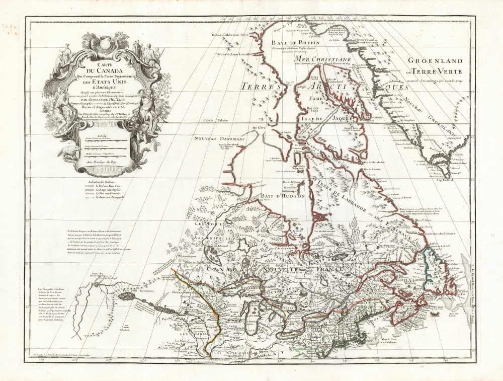
Carte du Canada Qui Comprend la Partie Septentrionale des Etats Unis D'Amerique.
1783 (dated) 20 x 26 in (50.8 x 66.04 cm) 1 : 10000000
1783 (dated) 20 x 26 in (50.8 x 66.04 cm) 1 : 10000000
Description
This is the 1783 Dezauche issue of Guillaume de l'Isle's seminal map of Canada and the Northern United States. Published after the close of the American Revolutionary War (1775 - 1783), this is one the first French maps to formally recognize the United States.
A Closer Look
De l'Isle's map first appeared in 1703. At that time, it was the most sophisticated cartographic representation of this region yet published, referencing various elements from the most recent explorations, including the Jesuit Relations, Pierre Le Moyne d'Ibervile, Pierre Le Sour, and Baron de Lahontan. The map's reach extends from Maryland and the Chesapeake north to Baffin Bay, including a superb depiction of the Great Lakes and Canada.A Topical Update to an Essential Map
At the close of the American Revolutionary War, in 1783, Dezauche, who had inherited De l'Isle's business from his immediate successor Buache, updated the classic 1703 map to include the borders of the newly-formed United States as established in the Treaty of Paris. United States territory is shown to begin in the northwest at the sources of the Mississippi. The border then extends eastward through the Lake of the Woods to bisect Lakes Superior, Huron, Erie, and Ontario (leaving Michigan or, as here, 'Lac des Illinois,' fully in U.S. territory). Eastward of the Great Lakes, the border passes northwest along the St. Lawrence before cutting east to divide Lake Champlain. It then follows the headlands to the Riviere Sainte-Croix, which exits into the Atlantic. To the west, the United States border is set along the Mississippi River.A Geographic Canard, Uncorrected
One of this map's most intriguing elements is De L'Isle's treatment of the speculative explorations of the Baron Louis Armand de Lahontan, which dominate the lower left. Lahontan (1666 - 1715) was a French military officer commanding the fort of St. Joseph near modern-day Port Huron, Michigan. Abandoning his post to live and travel with local Chippewa tribes, the Baron claimed to have explored much of the Upper Mississippi Valley and even to have discovered a river, which he dubbed the Riviere Longue or 'Long River.' He purported to have followed the river about half its length from its confluence with the Mississippi (the limit of his travels is marked 'Jusquicy est venue le Baron de Lahonton).' Beyond this point, Lahontan wrote of further lands along the river allegedly described by his guides. These included a great saline lake or sea (which De l'Isle included without clearly defining its bounds) and an extensive mountain range. De L'Isle expressed doubt about Lahontan's discoveries noting:Lahontan n'ait inventé toutes ces choses ce qu'il est difficile de resoudre étant le Seul qui a penetré dans ces vastes contrées.Nevertheless, Lahontan's information was followed by many important cartographers of his day: Moll, Popple, Sanson, and Chatelain to name just a few. But by the time Dezauche was editing this map so scrupulously on the East Coast, far better geographical information had become available, and the Lahontan geography shown here was, by 1783, a gross anachronism. Its preservation here is more a product of the authoritative nature of the map's geography of the East Coast than it is of any of its western features.
Lahontan [may have] invented all of these things, which is difficult to resolve as he was the only one to visit these vast lands. [our own translation]
An Amended Cartouche Revealing the Impact of Two Revolutions
The decorative title cartouche in the upper left features stylized New World fauna, including a beaver gnawing at the map's scales. Missionaries are shown converting indigenous American Indians. All these features were preserved from De l'Isle's 1703 work. The 1783 iteration of the map included the correction to its title to name the United States. Furthermore, this map is revealed to have been further amended and printed no earlier than 1789 (this state not in Tooley) as evidenced by the absence from the top of the cartouche of the French Fleurs de Lis, and the royal crown, which had become fatally unfashionable to display with the advent of the French Revolution.Publication History and Census
This map was published in J. Dezauche's 1789 reissue of G. De L'Isle and P. Buache's Atlas Geographique et Universel. We see 3 examples of the complete work listed in OCLC. Perhaps 20 examples of the separate map are cataloged in institutional collections.CartographerS
The De L'Isle family (fl. c. 1700 - c. 1760) (also written Delisle) were, in composite, a mapmaking tour de force who redefined early 18th century European cartography. Claude De L'Isle (1644 -1720), the family patriarch, was Paris based a historian and geographer under Nicholas Sanson. De L'Isle and his sons were proponents of the school of "positive geography" and were definitive figures, defining the heights of the Golden Age of French Cartography. Of his twelve sons, four, Guillaume (1675 - 1726), Simon Claude (1675 - 1726), Joseph Nicholas (1688 - 1768) and Louis (1720 - 1745), made a significant contributions to cartography. Without a doubt Guillaume was the most remarkable member of the family. It is said that Guillaume's skill as a cartographer was so prodigious that he drew his first map at just nine years of age. He was tutored by J. D. Cassini in astronomy, science, mathematics and cartography. By applying these diverse disciplines to the vast stores of information provided by 18th century navigators, Guillaume created the technique that came to be known as "scientific cartography", essentially an extension of Sanson's "positive geography". This revolutionary approach transformed the field of cartography and created a more accurate picture of the world. Among Guillaume's many firsts are the first naming of Texas, the first correct map of the Mississippi, the final rejection of the insular California fallacy, and the first identification of the correct longitudes of America. Stylistically De L'Isle also initiated important changes to the medium, eschewing the flamboyant Dutch style of the previous century in favor of a highly detailed yet still decorative approach that yielded map both beautiful and informative. Guillaume was elected to the French Academie Royale des Sciences at 27. Later, in 1718, he was also appointed "Premier Geographe du Roi", an office created especially for him. De L'Isle personally financed the publication of most of his maps, hoping to make heavy royalties on their sales. Unfortunately he met an untimely death in 1728, leaving considerable debt and an impoverished child and widow. De L'Isle's publishing firm was taken over by his assistant, Phillipe Buache who became, posthumously, his son in law. The other De L'Isle brothers, Joseph Nicholas and Louis De L'Isle, were employed in the Service of Peter the Great of Russia as astronomers and surveyors. They are responsible for cataloguing and compiling the data obtained from Russian expeditions in the Pacific and along the northwest coast of America, including the seminal explorations of Vitus Bering and Aleksei Chirikov. The De L'Isles, like their rivals the Vaugondys , must be considered speculative geographers. Speculative geography was a genre of mapmaking that evolved in Europe, particularly Paris, in the middle to late 18th century. Cartographers in this genre would fill in unknown areas on their maps with speculations based upon their vast knowledge of cartography, personal geographical theories, and often dubious primary source material gathered by explorers and navigators. This approach, which attempted to use the known to validate the unknown, naturally engendered many rivalries. The era of speculatively cartography effectively ended with the late 18th century explorations of Captain Cook, Jean Francois de Galaup de La Perouse, and George Vancouver. More by this mapmaker...
Phillipe Buache (February 7, 1700 - January 24, 1773) was a late 18th century French cartographer and map publisher. Buache began his cartographic career as the workshop assistant and apprentice to the important and prolific cartographer Guillaume de L'Isle. Upon De L'Isle's untimely death, Buache took over the publishing firm cementing the relationship by marrying De L'Isle's daughter. Over the years, Bauche republished many of De L'Isle's maps and charts. Buache was eventually appointed Premier Geographe du Roi, a position created-for and previously held by Guillaume de L'Isle. Buache is most respected for his introduction of hachuring as a method from displaying underwater elevation on a two dimensional map surface. Buache compiled maps based upon geographic knowledge, scholarly research, the journals of contemporary explorers and missionaries, and direct astronomical observation. Nevertheless, even in 18th century Paris geographical knowledge was severely limited - especially regarding those unexplored portions of the world, including the poles, the Pacific northwest of America, and the interior of Africa and South America. In these areas the Buache, like his primary rival Robert de Vaugondy, must be considered a speculative geographer or 'positive geographer'. Speculative geography was a genre of mapmaking that evolved in Europe, particularly Paris, in the middle to late 18th century. Cartographers in this genre would fill in unknown areas on their maps with speculations based upon their vast knowledge of cartography, personal geographical theories, and often dubious primary source material gathered by explorers and navigators. This approach, which attempted to use the known to validate the unknown, naturally engendered many rivalries. Buache's feuds with other cartographers, most specifically Didier Robert De Vaugondy, resulted in numerous conflicting papers being presented before the Academie des Sciences, of which both were members. The era of speculatively cartography effectively ended with the late 18th century explorations of Captain Cook, Jean Francois de Galaup de La Perouse, and George Vancouver. Buache was succeeded by his nephew Jean-Nicholas Buache de Neuville. Learn More...
Jean-Claude Dezauche (1745 - 1824) was a French map publisher active in Paris during the first half of the 19th century. He established his own engraving firm around 1770 after having engraved music since 1762. Dezauche bought the archives of Phillipe Buache and Guillaume de L'Isle from Jean Nicholas Buache, Buache's heir, in 1780. Dezauche soon obtained a monopoly on selling the charts produced by the Dépôt de la Marine. Jean-Claude Dezuache passed his business to his son, Jean André Dezauche, upon his death, who took over selling the Dépôt de la Marine charts. Learn More...
Source
Delisle, G., and Buache, P., Atlas Geographique et Universel, (Dezauche: Paris) 1789.
Condition
Excellent. Original platemark visible. Generous margins. Original outline color.
References
OCLC 1131676945. cf. Tooley, R. V., The Mapping of America, p. 20-1, #42, this state not recorded here. Kershaw, K. A., Early Printed Maps of Canada, 315. Karpinski, L. C., Bibliography of the Printed Maps of Michigan, 1804-1880, p. 40, 47.