This item has been sold, but you can get on the Waitlist to be notified if another example becomes available, or purchase a digital scan.
1907 Berthrong / Bond Map of the United States w/ Roads and Exploration
UnitedStatesExploration-berthrong-1907$475.00

Title
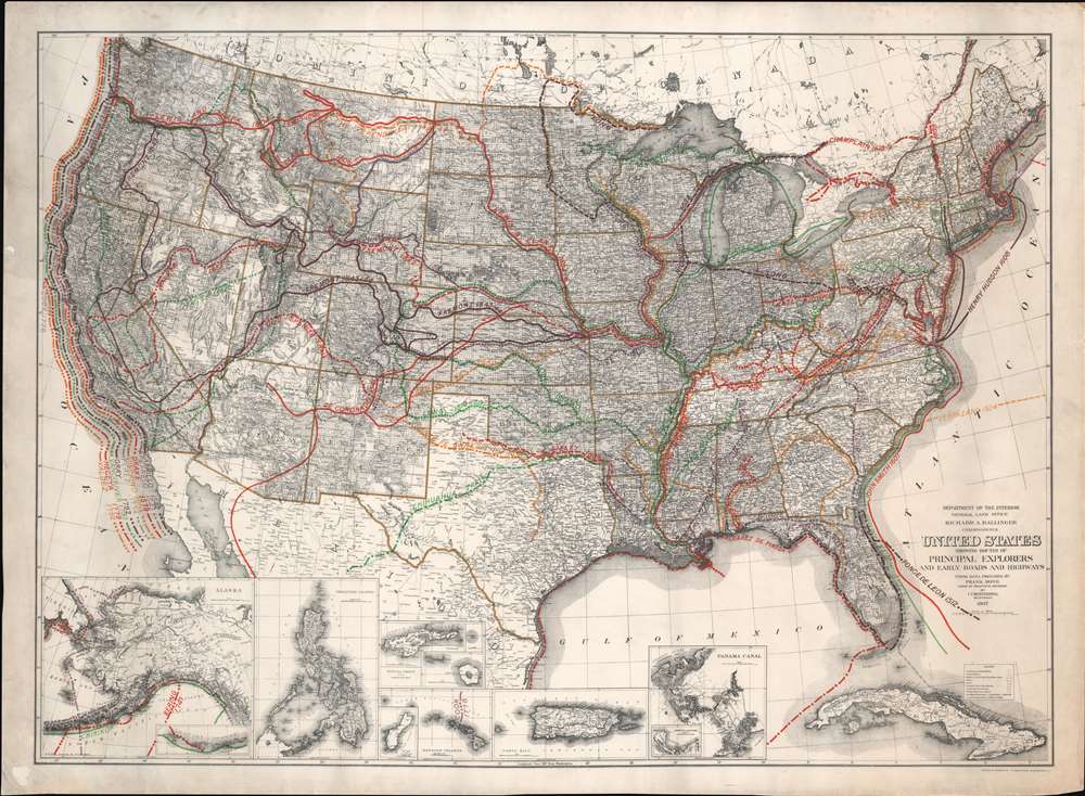
United States Showing Routes of Principal Explorers and Early Roads and Highways.
1907 (dated) 25 x 34 in (63.5 x 86.36 cm) 1 : 6000000
1907 (dated) 25 x 34 in (63.5 x 86.36 cm) 1 : 6000000
Description
A most fascinating production, this is a fine example of the 1907 first edition of the Berthrong / Bond map of the United States showing exploratory routes and improved roads. The base map is a reduction of the General Land Office map of the United States issued annually from 1899 to illustrate the extending and progress of the Public Surveys. That map has here been overlayed with color-coded routes illustrating the most prominent explorations from the 1500s through the mid-19th century. In addition, it shows important roads then in being built or improved, including the National highway, Braddock Road, the Great Trail. The map was intended to demonstrate the current state of geographical knowledge and underscore the fact that - by 1907, little was left unexplored.
The National Road
The National Road, begun in 1811 and completed in 1837, was the first major improved highway in the United States. The road has also been referred to as the Cumberland Turnpike, the Cumberland–Brownsville Turnpike (or Road or Pike), the Cumberland Pike, the National Pike, and the National Turnpike. The road, illustrated here by a dotted red line, connected the Ohio and Potomac Rivers and stretched from Cumberland, Maryland to the Illinois - Ohio border. Construction of the road came to an end when federal funding dried up due to the Panic of 1837.Braddock Road
The Braddock Road was opened by the Ohio Company in 1751 and rand from Fort Cumberland, the limit of navigation on the upper Potomac River, to the French military station at Fort Duquesne (Pittsburg) at the forks of the Ohio River. It received its name during the colonial-era French and Indian War (1753 - 1763), when it was improved by British General Edward Braddock. Braddock was accompanied by Virginia Militia Colonel George Washington on the disastrous 1755 Braddock Expedition's assault on French-held Fort Duquesne.Publication History and Census
This map was issued in the present first edition by the Department of the Interior General Land Office (GLO) in 1907. The data was compiled by Frank Bond and the map was drafted by Ithamar Parsons Berthrong. The base map was reduced by M. Hendges. It was lithographed in Washington D. C. by Andrew B. Graham. At least three subsequent editions followed, with the last known edition, the fourth, appearing in 1937.CartographerS
Ithamar Parsons Berthrong (February 26, 1853 - July 29, 1936) was an American surveyor, inventor, and draftsman active with the General Land Office of the U.S. Department of the Interior. Berthrong was born in Rochester, New York. He was made chief of the drafting division on March 23 of 1907. He is associated with many of the most important early 20th century maps issued by the GLO, among them, important maps of Arizona, Colorado, Wyoming, Oregon, Washington, and more. More by this mapmaker...
Frank Bond (1856 - 1940) was an American cartographer, draftsman, surveyor, illustrator, and politician. Born in rural Jones County, Iowa, Bond graduated from the University of Iowa. In 1772, he moved to Cheyenne Wyoming, where he worked for the Wyoming Surveyor-General's Office and later the General Land Office as a draftsman. He left this position to edit the Cheyenne Tribute and engage in local politics. Bond was elected as a member of the first Wyoming legislature. In 1900, he moved to Washington, D.C., where he held the positions of Chief of the Drafting Division and Chief Clerk at the General Land Office. While at the Land Office, Bond helped determine the borders of Yosemite National Park . As a skilled mapmaker and illustrator, Bond created numerous maps. He was also an active illustrator, painter and ornithologist, creating and preserving bird refuges throughout the country. He had a twin brother, Fred Bond, was also an important surveyor and draftsman. Learn More...
The General Land Office (GLO) (1812 - 1946) was an independent agency of the United States government responsible for public domain lands in the United States. Created in 1812, it took over functions previously conducted by the Department of the Treasury. The GLO oversaw the surveying, platting, and sale of public lands in the western United States. It also administered the Preemption Act of 1841, which allowed individuals who were already living on federal land to purchase up to 160 acres of land before it was offered for sale to the general public, if they met certain requirements. Following the passage of the Homestead Act in 1862, which was also administered by the GLO, claims under the Preemption Act sharply decreased. The GLO became a part of the newly-created Department of the Interior in 1849. In 1891 Grover Cleveland and Congress created 17 forest reserves, due to public concern over forest conservation, which were initially managed by the GLO, until they were transferred to the Forest Service in 1905. In 1946 the Government Land Office was merged with the United States Grazing Service to become the Bureau of Land Management. Today the Bureau of Land Management administers the roughly 246 million acres of public land remaining under federal ownership. Learn More...
Andrew B. Graham (1845 - September 9, 1909) was an American lithographer active in Washington, D.C. in late 19th and early 20th century. Graham was born in Washington D.C., the son of a lithographer and engraver. After college, he joined the U.S. Coast Survey, where he was a draftsman until 1889. He retired from the Coast Survey to take over management of his father's lithography firm. The firm, Andrew B. Graham Company, was one of several that thrived on lucrative government publication contracts. Graham died of 'brain fever' in his Washington D. C. residence on September 9 of 1909. Some of his work was republished posthumously until about 1917, and his firm was active until at least the early 1920s. Learn More...
Condition
Very good. On original linen. Some edge toning.
References
OCLC 35064333. 'America transformed. Part 1: the United States expands westward,' organized by the Norman B. Leventhal Map and Education Center at the Boston Public Library, 2019. Boston Public Library, Leventhal Center, G3701.S12 1908 .B47. Yale University, 75j 1908.