This item has been sold, but you can get on the Waitlist to be notified if another example becomes available, or purchase a digital scan.
1795 Carey / Doolittle Map of Vermont
Vermont-carey-1795-2$475.00

Title
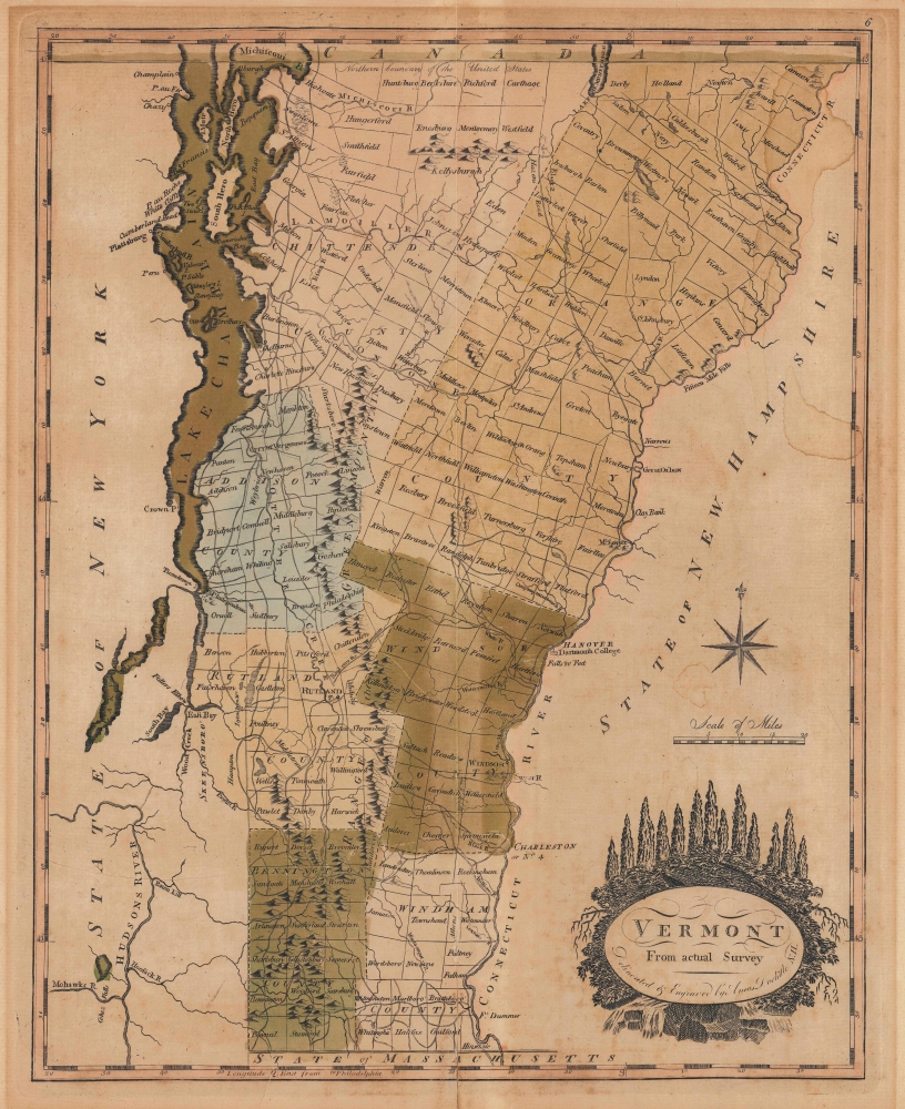
Vermont From Actual Survey.
1795 (undated) 15.25 x 12.25 in (38.735 x 31.115 cm) 1 : 696960
1795 (undated) 15.25 x 12.25 in (38.735 x 31.115 cm) 1 : 696960
Description
This is the first map of Vermont published in the United States, here in striking original color. This 1795 work was drawn and engraved by Amos Doolittle for Matthew Carey's Carey's American Edition of Guthrie's Geography Improved, the first atlas published in the United States.
Vergennes is marked simply as 'city,' due to the unique circumstances of its creation; it was not chartered as a town or village but instead cobbled together from pieces of preexisting neighboring towns. Consequently, it is known as 'Vermont's first city,' as well as 'America's smallest city,' as it occupies only two square miles.
Several towns have changed names since the publication of this map, while new towns were added in the small unincorporated parts of the state, especially along the Green Mountains and in the state's far north, near the border with Quebec. For example, Harwick in southeastern Rutland County later became Mount Tabor, while the unincorporated mountainous area to its east became Weston (incorporated 1799). Similarly, Newport, on Lake Memphremagog, was only founded in 1793, too late to be included in Doolittle's data, while the nearby town of Carthage later changed its name to Jay to honor John Jay.
Longitude is measured from Philadelphia, then the U.S. capital, as is common on Carey's maps. A lovely title cartouche highlights Vermont's dense forests and running rivers.
A Closer Look
Counties and towns, roads, rivers, lakes, mountains, and other features are labeled throughout. Especially notable are Burlington (still quite small at this time), Bennington, and Dartmouth College across the Connecticut River in Hanover, New Hampshire.Vergennes is marked simply as 'city,' due to the unique circumstances of its creation; it was not chartered as a town or village but instead cobbled together from pieces of preexisting neighboring towns. Consequently, it is known as 'Vermont's first city,' as well as 'America's smallest city,' as it occupies only two square miles.
Several towns have changed names since the publication of this map, while new towns were added in the small unincorporated parts of the state, especially along the Green Mountains and in the state's far north, near the border with Quebec. For example, Harwick in southeastern Rutland County later became Mount Tabor, while the unincorporated mountainous area to its east became Weston (incorporated 1799). Similarly, Newport, on Lake Memphremagog, was only founded in 1793, too late to be included in Doolittle's data, while the nearby town of Carthage later changed its name to Jay to honor John Jay.
Longitude is measured from Philadelphia, then the U.S. capital, as is common on Carey's maps. A lovely title cartouche highlights Vermont's dense forests and running rivers.
The Vermont Republic and Vermont's Early History
Vermont has always done things a little differently. Despite the important contributions of Vermonters (especially the 'Green Mountain Boys') to the American Revolutionary War (1775 - 1783), Vermont was an independent republic for the duration of the conflict. Due to territorial disputes with New York, Vermont even considered joining Quebec at one point. Following the defeat of the British, momentum built for Vermont joining the Union and an agreement was reached on the territorial dispute with New York in 1790. The following March, Vermont was quickly admitted to the Union. The state was sparsely populated at the time but saw significant growth at the close of the 18th century. The 1790 census, actually conducted in 1791, counted 85,425 residents, while that of 1800 listed 154,465.Publication History and Census
This map was drawn and engraved by Amos Doolittle for inclusion in Matthew Carey's 1795 Carey's American Edition of Guthrie's Geography Improved, published in Philadelphia. The same map also appeared in the largely overlapping Carey's American Atlas, published soon afterwards; even the note along the top border here was retained for the American Atlas printing. Later editions of Carey's atlas printed in the early 19th century also continued to use this map, with some updates. Regardless of printing, the 1795-1796 edition of the map is only independently cataloged in OCLC by the Bayerische Staatsbibliothek.CartographerS
Matthew Carey (January 28, 1760 - September 16, 1839) was a Dublin born publisher who established himself in Philadelphia in the late 18th and early 19th century. A young man of socially progressive views, Carey's first known publication, produced when he was but 17 years old, was a pamphlet criticizing dueling. Another pamphlet, issued in the same year, attacked the Irish penal code. Shortly afterwards, in 1779, legal issues, possibly arising from his liberal political activism, forced Carey to flee to Paris. In Paris, Carey had the good fortune to befriend the visiting American diplomat and founding father, Benjamin Franklin (1706 - 1790). As an Irishman chafing under the rule of England, Carey sympathized with and admired the American revolutionary. The liberally minded pair struck up a lifelong friendship and Carey was hired to work at Franklin's press in Passy, France. A year later, Carey returned to Ireland and resumed his politically provocative publishing career with The Freemans's Journal and The Volunteer's Journal. It didn't take long for political pressure to once again force Carey from Ireland - this time to America (1784). Although largely without funds, Carey convinced Gilbert du Motier, Marquis de Lafayette (1757 - 1834), who he knew from Franklin's Paris circle, to lend him funds to establish a new publishing concern in Philadelphia. Despite this loan, Carey's firm remained under financed and opened on a shoestring budget. It was most likely his limited budget that led Carey to some of his most important publishing innovations. At the time cartographic publishing was dominated by large printing houses in London and Paris where most, if not all, of the work was completed in house. Without the finances to emulate this large publishing houses, Carey was forced to outsource much of his publishing work. This set the stage for subsequent American publishers who, in order to compete effectively with European firms, relied on an often bewildering network of alliances and collaborations. Carey was also a master of republishing many of his own maps in multiple different atlases and formats to maximize their profitability. His most important work is without a doubt the 1795 issue of the American Atlas the first atlas to be published in America. Carey died in 1839 but was succeeded by his son Henry Charles Carey (1793 - 1879) who, in partnership with his brother-in-law Isaac Lea (1792 - 1886), published numerous important maps and atlases under the Carey and Lea, Lea Brothers, and Lea and Blanchard imprints. More by this mapmaker...
Amos Doolittle (May 18, 1754 - February 2, 1832) was an American engraver, silversmith, and map publisher active in Connecticut during the late 18th and early 19th centuries. Most likely because of the overlap in their careers and lifetimes, Doolittle is often referred to as the 'Revere of Connecticut'. He was born in Cheshire, Connecticut, the son of Ambrose and Martha Munson Doolittle. He apprenticed under the silversmith Eliakim Hitchcock. Doolittle was a self-taught artist who specialized in copper engraved scenes from the American Revolutionary War. Having acquired a considerable reputation as an engraver, Doolittle was sought out by many early Americans eager to learn the art, including James Wilson and Ralph Earl. Cartographically Doolittle is recognized for engraving several important maps of New Haven and Connecticut. Later in life he began publishing as 'Amos Doolittle and Son', having brought his sone into the business. We do not know who this is, but at least one imprint is signed 'Amos and A. B. Doolittle', so he may be Amos Jr.? During the Revolutionary War he served under Benedict Arnold as a member of the Governor's Second Company of Guards. Following the war he settled in New Haven, Connecticut and is buried in that town's Grove Street Cemetery. Learn More...
William Guthrie (1708 - March 9, 1770) was a Scottish historian, journalist, and writer. Born in Brechin, he studied at Aberdeen University with the idea of becoming a parochial schoolmaster. Instead, in 1730, he elected to settle in London and try his hand at literature. He covered parliamentary debates f or the Gentleman's Magazine and soon earned a reputation for being a political writer. He published several scholarly works, including a History of England from the Invasion of Julius Caesar to 1688 in four volumes, and, most notably, his Geographical Historical, and Commercial Grammar. Learn More...
Source
Carey, M., Carey's American Edition of Guthrie's Geography Improved, (Philadelphia) 1795.
Condition
Fair. Centerfold exhibits wear and verso reinforcement. Toning and aged original color. Some dampstaining in upper right quadrant.
References
Rumsey 2542.004. OCLC 163340327.