
1903 Philip Bird's-Eye View Map of Natal During the Second Boer War

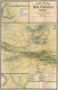

Bird's Eye View of War District Natal. To Accompany the Official Railway Guide.
Devilish Fight to Dislodge the Boers.
- Digital Map Information
- Suitable for large format printing
- File Size: 51.41 MB
- File Type: ZIP / TIFF
- ICC color profile embedded
- Delivered instantly via download link
Devilish Fight to Dislodge the Boers.
This is a 1903 George Philip and Son bird's-eye view of Natal, now KwaZulu-Natal, South Africa. It provides a detailed and comprehensive overview of the Second Boer War (1899 - 1902), a difficult conflict that had important implications for the British Empire and the changing nature of warfare.A Closer Look
This sheet includes three views with supplementary information, with the largest at center being an overview of the heartland of Boer resistance in Natal, between Colenso and Ladysmith (uMnambithi). Roads, railways, waterways, areas of elevation, regions, and settlements are noted. A range of symbols represents different aspects of the military campaign, as described in the legend below the title and a reference list at the bottom right. Numbers on the map refer to the locations of different key positions, skirmishes, and battles that occurred in late 1899 and early 1900. An inset at top-left depicts fighting around Dundee in the earliest stage of the conflict in October 1899. A smaller inset view portrays the elevation and Boer positions around Colenso, the site of a disastrous British defeat on December 15, 1899, which nonetheless saw British troops exhibit remarkable bravery in saving artillery from being captured by the Boers. An inset at bottom-left displays the coastal region of Natal around Durban as far inland as Brynbella and environs, where the British force to relieve Ladysmith first encountered Boer strongholds.Natal and the Second Boer War
Natal was a particularly fraught region, as it had earlier been a short-lived independent Boer republic that was incorporated into the British Cape Colony in 1843-44, a move grudgingly accepted by many Boers as their presence had led to regular fighting with the indigenous Zulu population. Although most Boers fled the new colony for the Orange Free State and Transvaal, a handful remained, particularly deep in the interior, and seethed at British rule and the influx of settlers and workers from Europe and India.Also known as the Boer War, Anglo-Boer War, or South African War, the Second Boer War (October 11, 1899 - May 31, 1902) was a conflict fought between the British Empire and the independent Boer states, the Republic of Transvaal / South African Republic (Zuid-Afrikaansche Republiek) and the Orange Free State. Although tensions in southern Africa between the British and the Boers had been simmering for nearly a century, the Second Boer War was sparked by the discovery of the Witwatersrand Gold Reef near modern-day Johannesburg in 1886. British and other foreign fortune hunters, uitlanders as they were known among the Boers, poured into the region, threatening Boer sovereignty. Boers were also unhappy about the expanding rail network in Natal, which they perceived as a means of imposing British control and linking the Boer territories more closely with the British global trade network, which would necessarily bring in more uitlanders.
After negotiations to address the tensions failed, the Boers mobilized their militias quickly, seized the railways in the interior of Natal, and successfully won a string of battles. Although a ragtag force at first glance, the Boers had the advantage of knowing the terrain, being experienced hunters and horsemen, and having a strong motivation to resist, emboldened by their victory in the First Boer War twenty years prior. They descended on Natal and besieged several settlements, including Ladysmith and Colenso. British counterattacks under Gen. Redvers Buller (depicted here) initially failed miserably, but with superior numbers, the British managed to relieve Ladysmith in February 1900. The war humbled the great imperial power, and Buller was replaced by the more capable Lord Roberts (1832 - 1914). Reinforcements flooded into South Africa, bringing more than 400,000 men from far-flung colonies.
Having regrouped, the British under Roberts were able to relieve the sieges and win a string of battles in February 1900. The Boers were completely outnumbered, and within a few months, the British seized control of both the Orange Free State and the Transvaal. Nevertheless, fighting continued in the form of guerrilla attacks, countered with sometimes brutal scorched-earth tactics and the mass internment of civilians, until a negotiated settlement was reached in 1902. The war gained considerable international attention and was notable for presaging later developments in warfare, such as the use of barbed wire and machine guns, as well as concentration camps for civilians.
Publication History and Census
This map was originally compiled by C.W.F. Harrison and J. C. Sturgeon and was then published by George Philip and Son to accompany Harrison's Natal: an illustrated official railway guide and handbook of general information, published in London in 1903. The map is only independently cataloged in OCLC at the University of KwaZulu-Natal and the Msunduzi Municipal Library, and it appears on the private market from time to time. The entire book is well-represented in institutional collections, being held by roughly 15 institutions.Cartographer
George Philip (1800 - 1882) was a map publisher and cartographer active in the mid to late-19th century. Philip was born into a Calvinst family in Huntly, Aberdeenshire, Scotland. Around 1819 he apprenticed himself to William Grapel, a Liverpool printer and bookseller. Fifteen years later, in 1834, Philip founded his own Liverpool book and map firm. Philip's earliest cartographic ventures were mostly educational material issued in tandem with John Bartholomew Sr., August Petermann, and William Hughes. In 1848, Philip admitted his son, George Philip Jr. (1823 - 1902) into the firm, renaming it George Philip and Son Ltd. George Philip Jr. ran the firm until his death in 1902, by which time it had developed into a major publishing concern. His successors established the London Geographical Institute, a factory where they embraced modern printing techniques to produce thousands of economical and high quality maps. In April 1988, George Philip & Son was acquired by Octopus Publishing, a branch of Reed International. Nonetheless, today the firm trades and publishes to this day as George Philip and Son. Further Details...
Source
Harrison, C. W., Natal : an illustrated official railway guide and handbook of general information, (London: Payne Jennings) 1903.
Condition
Good. Wear along original fold lines. Creasing. Old verso repairs at fold intersections. Verso repairs to fold separations and at fold intersections.
References
OCLC 896620834, 1046515715. Entire book - OCLC 229920585, 65679834. National Library of Australia Bib ID: 8124103. University of Cape Town Pamphlet Collection BAP 916.83 HAR.