
1899 Britton and Rey Map of San Francisco Sewer System

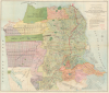

System Of Sewerage for the City and County of San Francisco.
The Best Laid Plans...
- Digital Map Information
- Suitable for large format printing
- File Size: 53.09 MB
- File Type: ZIP / TIFF
- ICC color profile embedded
- Delivered instantly via download link
The Best Laid Plans...
This is a scarce 1899 map of a planned but never-realized sewer system for the city (and county) of San Francisco, printed by Britton and Rey. Aside from its representation of the planned sewer system, the map is also significant for representing similar planned but only partly realized street layouts in newly-developing areas in the western and southern parts of the city.A Closer Look
As the largest city in the western United States at the time, San Francisco was a model metropolis and its city planners knew it. To accommodate the city's growing population, civil engineers devised ways to make the city both beautiful and functional. The partially-completed 'sewerage system' charted here was meant to drain low lying parts of the city where rainwater and sewage tended to collect, connect houses to wider, modern sewer networks (though not mentioned here, the accompanying report explains that the city is to be divided into sewer districts noted here by color-shading and outlines), and drain sewage via outfalls into the Bay or the ocean. However, as with many of San Francisco's urban plans in this era, this sewerage plan was never fully realized, mostly due to the destructive 1906 earthquake and fire. Afterwards, resources were directed towards reconstruction and improving the city's incoming water supply to fight any future fires. It took several decades before a modern citywide system of sewers and drainage was established, by which time new technologies and changes in the overall urban plan resulted in a different result than that envisioned here. Even today, the city struggles to find an environmentally-responsible way to dispose of its sewage, as a recent U.S. Supreme Court case highlighted (City and County of San Francisco v. EPA).In addition to the sewer system, the map is notable for displaying elevations with hachure lines throughout the city, giving a sense of its many hills and valleys. The map also includes street grids for parts of the city that were virtually uninhabited at the time, such as the Richmond and Sunset Districts. Even the partially developed portions along the edge of the main part of the city would be rethought in the aftermath of the 1906 earthquake and fire. For example, Market St. is seen here ending at Castro St., but would later be extended up towards Twin Peaks before turning into Portola Dr. near Clipper St. Likewise, the nearby neighborhoods of 'Stanford Heights' and 'Sunnyside Add'n' (now Diamond Heights and Miraloma Park) would not be built with the geometric street grid seen here but with winding streets following the area's topography, the preferred means of laying out streets in the aftermath of the earthquake.
In a similar manner, the streets in the hillier areas between India Basin and South Basin (Bayview-Hunters Point) also were built to follow topography rather than a fixed grid, as seen here. Much of the landfill areas ghosted in at right here were built with a fairly geometric street grid as imagined, though the plans for future development were a bit too ambitious, with the landfill ending around Maryland Street instead of extending for another several blocks north and south of the Islais Creek Channel. The landfill proposed in the Marina District here was also scuttled by the 1906 earthquake, after which only a portion of the landfill was undertaken (using rubble from the earthquake to shore up the sandy terrain), upon which the grounds of the 1915 Panama-Pacific Exposition were built.
More generally, the map is significant for reflecting structures and streets that were actually built around this time, rather than just planned. For example, this map identifies the Parnassus location of the 'Affiliated Colleges,' the basis for today's University of California San Francisco.
Publication History and Census
This map was prepared by civil engineers C. E. Grunsky, Marsden Manson, and C. S. Tilton, and was printed by San Francisco stalwarts Britton and Rey. It appeared as Plate No. 6 in the 1899 Report Upon a System of Sewerage for the City and County of San Francisco co-authored by Grunsky, Manson, and Tilton. This map is only independently cataloged among the holdings of Stanford University / the David Rumsey Historical Map Collection and the University of California Berkeley, while the entire report is more broadly distributed in institutional collections. Both the map and the entire report are very scarce to the market, with the most recent sale we can identify being in 2015.Cartographers
Britton and Rey (1852 - 1916) was a lithographic firm based in San Francisco founded by Joseph Britton (1825 - 1901) and Jacques Joseph Rey (1820 - 1892). The leading firm in the area during the second half of the 19th century, Britton and Rey eventually earned the reputation of being the western Currier and Ives. They published both large-format and postcard views of California, as well as with stock certificates, stationery, and maps. Within the partnership, Rey was the artist and Britton the principal lithographer. Britton was also principally concerned with the business aspects of the firm. The firm also printed lithographs by other artists, including Thomas Almond Ayres (1816 - 1858), George Holbrook Baker (1824 - 1906), Charles Christian Nahl (1818 - 1878), and Frederick August Wenderoth (1819 - 1884). After Rey's death in 1892 and Britton's subsequent retirement, the firm passed to Rey's son, Valentine J. A. Rey, who ran the firm until at least the 1906 San Francisco earthquake and fire. A. Carlisle and Company, another San Francisco printer, acquired the remains of the Britton and Rey firm in 1916. For more information about Joseph Britton and Jacques Joseph Rey, please reference their individual biographies included in our cartographer database. Further Details...
Joseph Britton (1825 - July 18, 1901) was born in Yorkshire, England, and immigrated to the United States in 1835 with his family, living in New York City, becoming a lithographer by 1847. In 1849, he left New York to seek his fortune in California during the California Gold Rush. He made the journey with George Gordon’s ‘Gordon’s California Association’, and chose the voyage which included an overland trek via Nicaragua. The voyage was supposed to last 60 days, but instead lasted an incredible 8 months. After several unsuccessful years in various gold mining camps, Britton relocated to San Francisco and established a lithography firm, probably in 1851, and then entered into a short-lived collaboration with C.J. Pollard in 1852, named Pollard and Britton. By late 1852, Britton had formed a partnership with the lithographer Jacques Joseph Rey. Rey married Britton’s sister in 1855, but Britton remained a life-long bachelor and lived with the Rey family. Rey and Britton were well integrated into San Francisco. They owned a plumbing and gas-fitting firm, which apparently Rey managed. They also worked with several different lithographers off and on, but their partnership solidified by 1867. Britton was one of the three original investors in Andres Hallidie’s first San Francisco cable-car line on Clay Street and served twice as a San Francisco City and County Supervisor. Further Details...
Jacques Joseph Rey (1820 - 1892) was born in Bouxwiller, Alsace, France, and apparently was trained in art and lithography. Around 1850, he immigrated to California. Rey, a lithographer by training, entered into a partnership with Joseph Britton (1825 - 1901) by late 1852. Rey married Britton’s sister in 1855, but Britton, who remained a life-long bachelor, lived with the newlyweds. Rey and Britton were well integrated into San Francisco. They owned a plumbing and gas-fitting firm, which apparently Rey managed. They also worked with several different lithographers off and on, but their partnership solidified by 1867. Following Rey’s death and Britton’s retirement, Rey’s son, Valentine J. A. Rey, took over the business and ran it at least until the 1906 San Francisco earthquake and fire. The firm continued to produce works until 1915, after which it was acquired by A. Carlisle and Company. Further Details...
Source
Grunsky, C, Manson, M. and Tilton, C., Report upon a system of sewerage for the city and county of San Francisco, (San Francisco: City and County of San Francisco) 1899.
Condition
Very good. Minor reinforcement on verso at fold intersections.
References
Rumsey 3683.000. OCLC 25885318.