1867 (1878) U.S. Coast Survey Chart, Northern Massachusetts, New Hampshire, Southern Maine Coast
WellsToCapeAnn-uscs-1878$600.00

Title
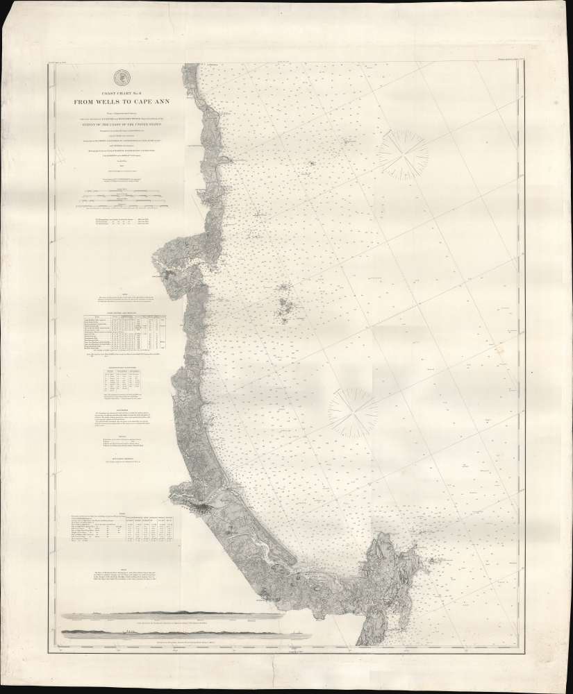
Coast Chart No. 8 From Wells to Cape Ann.
1878 (dated) 37.5 x 30 in (95.25 x 76.2 cm) 1 : 80000
1878 (dated) 37.5 x 30 in (95.25 x 76.2 cm) 1 : 80000
Description
A remarkably detailed nautical map or chart originally produced by the U.S. Coast Survey in 1867, updated to 1878, of the Atlantic coast of New England from Wells and Ogunquit in Maine to Gloucester on Cape Ann, Massachusetts.
The land along the coast is illustrated to a minute degree of precision, to roughly a mile inland (at bottom up to the Eastern Railroad, running between Boston and Portland, Maine), with individual farms and buildings indicated. At bottom-left are two profile views of the coastline near Thatcher's Island off Cape Ann and the entrance to the harbor at Gloucester, respectively.
A Closer Look
Coverage ranges from the beaches below Wells (the town itself is off the map just to the north) and Ogunquit in Maine, through Portsmouth and the brief section of New Hampshire coastline, and through Newburyport, Ipswich, Rockport, and Gloucester, Massachusetts. Fathoms, shoals, hazards, islands, lighthouses and beacons (also listed in a table at left), buoys (marked in red and black), and other navigational essentials are noted in tremendous detail and to a distance far from the coast, out into open ocean. Extensive information is also provided, via abbreviations (listed in another table at left), on the type of mud, rock, and other material at the ocean bottom. Additional data is provided at left, including tables of tides and notes on soundings and the shifting of buoys and lights.The land along the coast is illustrated to a minute degree of precision, to roughly a mile inland (at bottom up to the Eastern Railroad, running between Boston and Portland, Maine), with individual farms and buildings indicated. At bottom-left are two profile views of the coastline near Thatcher's Island off Cape Ann and the entrance to the harbor at Gloucester, respectively.
Fishtown
At this time, Gloucester was the center of the New England fishing industry, staffed by immigrants from the Azores and Italy, and a thriving commercial port as well. The fishing industry was long established in the city but had fallen to a nadir in the early 19th century before reviving in the mid-19th century. Cod fishing was particularly important to the city's economy, and improved charts such as this were invaluable to mariners working the increasingly crowded shores and waters off New England. Still, fishing was a dangerous business. In 1879, just a year after this chart's publication, 279 fishermen died when their ships were lost at sea, with one particularly nasty gale on Georges Bank in February 1879 sinking 13 ships carrying nearly 150 crew members. For the town's tercentenary in 1923, a large bronze statue was commissioned to memorialize the fisherman lost at sea throughout the town's history; today, the statue is one of the town's main landmarks.Publication History and Census
This chart was originally published in 1867 by the U.S. Coast Survey, then re-issued in 1877 with corrections, and the present example was printed in 1878 with minor changes to navigational aids (i.e. the magnetic variation or declination in the compasses). The OCLC notes it among the holdings of Stanford University, the University of Chicago, the University of Virginia, the Boston Public Library, Salem State University, and the Staats- und Universitätsbibliothek Bremen.CartographerS
The Office of the Coast Survey (1807 - present) founded in 1807 by President Thomas Jefferson and Secretary of Commerce Albert Gallatin, is the oldest scientific organization in the U.S. Federal Government. Jefferson created the "Survey of the Coast," as it was then called, in response to a need for accurate navigational charts of the new nation's coasts and harbors. The spirit of the Coast Survey was defined by its first two superintendents. The first superintendent of the Coast Survey was Swiss immigrant and West Point mathematics professor Ferdinand Hassler. Under the direction of Hassler, from 1816 to 1843, the ideological and scientific foundations for the Coast Survey were established. These included using the most advanced techniques and most sophisticated equipment as well as an unstinting attention to detail. Hassler devised a labor intensive triangulation system whereby the entire coast was divided into a series of enormous triangles. These were in turn subdivided into smaller triangulation units that were then individually surveyed. Employing this exacting technique on such a massive scale had never before been attempted. Consequently, Hassler and the Coast Survey under him developed a reputation for uncompromising dedication to the principles of accuracy and excellence. Unfortunately, despite being a masterful surveyor, Hassler was abrasive and politically unpopular, twice losing congressional funding for the Coast Survey. Nonetheless, Hassler led the Coast Survey until his death in 1843, at which time Alexander Dallas Bache, a great-grandson of Benjamin Franklin, took the helm. Bache was fully dedicated to the principles established by Hassler, but proved more politically astute and successfully lobbied Congress to liberally fund the endeavor. Under the leadership of A. D. Bache, the Coast Survey completed its most important work. Moreover, during his long tenure with the Coast Survey, from 1843 to 1865, Bache was a steadfast advocate of American science and navigation and in fact founded the American Academy of Sciences. Bache was succeeded by Benjamin Pierce who ran the Survey from 1867 to 1874. Pierce was in turn succeeded by Carlile Pollock Patterson who was Superintendent from 1874 to 1881. In 1878, under Patterson's superintendence, the U.S. Coast Survey was reorganized as the U.S. Coast and Geodetic Survey (C & GS) to accommodate topographic as well as nautical surveys. Today the Coast Survey is part of the National Oceanic and Atmospheric Administration or NOAA as the National Geodetic Survey. More by this mapmaker...
Alexander Dallas Bache (July 19, 1806 - February 17, 1867) was an American physicist, scientist and surveyor. Bache is best known in cartographic circles as the Superintendent of the U.S. Coast Survey from 1843 to 1865. Born in Philadelphia, Bache, a great grandson of the statesman and inventor Benjamin Franklin, had a varied career primarily focused on education. He toured Europe on behalf of Girard College and composed an important treatise on European Education. Later he served as president of Philadelphia's Central High School and was a professor of natural history and chemistry at the University of Pennsylvania. On the death of Ferdinand Rudolph Hassler, Bache was appointed Superintendent of the United States Coast Survey. Picking up where Hassler left off Bache presided over the Survey during its most prolific period and oversaw the mapping of most of the United States coastline. To this day his name appears on countless marine pilot books and U.S. Coast Survey nautical charts. For his work he was elected Associate Fellow of the American Academy of Arts and Sciences, a Fellow of the Royal Society of Edinburgh, and a Foreign Member of the Royal Society. Following the Civil War, Bache was elected a 3rd Class Companion of the Military Order of the Loyal Legion of the United States. He died at Newport, Rhode Island and was buried in the Congressional Cemetery in Washington, DC, where he is commemorated with a monument built by American architect Henry Hobson Richardson. Learn More...
Carlile Pollock Patterson (August 24, 1816 - August 15, 1881) was the fourth superintendent of the United States Coast Survey. Born in Shieldsboro (now Bay St. Louis), Mississippi and the son of the American naval officer Daniel Todd Patterson (1786 - 1839), Carlile joined the navy as a midshipman in 1830. He graduated from Georgetown College in Kentucky as a civil engineer in 1838 and was attached to the U.S. Coast Survey from 1838 - 1841. In 1841, he was commissioned as a lieutenant. As commander of the Coast Survey schooner Phoenix, Patterson led the first USCS hydrographic expedition of the Gulf of Mexico in 1845. Patterson resigned from the Navy in 1853. At the outbreak of the Civil War in 1861, Patterson returned to federal service as a civilian hydrographic inspector in the Coast Survey, in charge of the charting and survey work. He was appointed as the Superintendent of the U.S. Coast and Geodetic Survey in 1874, a post he held until his death. Learn More...
Condition
Good. Large tear extending 7 inches into the map on center bottom, closed on verso. Professionally repaired and backed on linen.
References
OCLC 317745027.