1796 Carey Map of the West Indies
WestIndies-carey-1796$250.00

Title
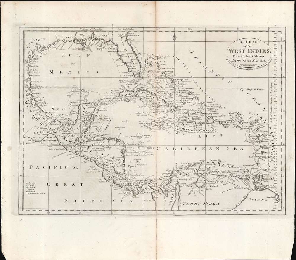
A Chart of the West Indies From the Latest Marine Charts and Surveys.
1796 (undated) 11.5 x 15.75 in (29.21 x 40.005 cm) 1 : 11750000
1796 (undated) 11.5 x 15.75 in (29.21 x 40.005 cm) 1 : 11750000
Description
This is a c. 1796 map of the West Indies from Carey's General Atlas, the first atlas published in the new American Republic.
The prevalence of the map is difficult to determine since it is not always cataloged with the year recorded and there is a proliferation of catalog listings for the Carey atlas maps, but it appears to be held by a handful of universities and research institutions in the United States while being scarce to the market.
A Closer Look at the Map
The map stretches from the Spanish and French colonies of West Florida and Louisiana at north to the modern states of Columbia, Venezuela, and Guyana in the south. A small key at bottom-left lists the abbreviations used to distinguish the ownership for various islands and territories between competing empires. One interesting feature of this map is the use of Philadelphia, where it was engraved and published, as the prime meridian. It also includes a scale of nautical leagues along the right side of the map.Publication History and Census
This map is likely from an early edition of Carey's General Atlas (sometimes subtitled American Edition of Guthrie's Geography improved), multiple editions of which were printed between 1795 and 1818. This is likely an early edition as later editions included colored ink to show borders between countries or to shade entire countries to more easily distinguish them. The map itself provides some clues as to its date, as it appears to predate the dispute over West Florida between Spain and the United States (later editions of the map remove West Florida). The western half of Hispaniola is referred to as belonging to France, so the map must predate 1804, when Haiti became independent.The prevalence of the map is difficult to determine since it is not always cataloged with the year recorded and there is a proliferation of catalog listings for the Carey atlas maps, but it appears to be held by a handful of universities and research institutions in the United States while being scarce to the market.
CartographerS
Matthew Carey (January 28, 1760 - September 16, 1839) was a Dublin born publisher who established himself in Philadelphia in the late 18th and early 19th century. A young man of socially progressive views, Carey's first known publication, produced when he was but 17 years old, was a pamphlet criticizing dueling. Another pamphlet, issued in the same year, attacked the Irish penal code. Shortly afterwards, in 1779, legal issues, possibly arising from his liberal political activism, forced Carey to flee to Paris. In Paris, Carey had the good fortune to befriend the visiting American diplomat and founding father, Benjamin Franklin (1706 - 1790). As an Irishman chafing under the rule of England, Carey sympathized with and admired the American revolutionary. The liberally minded pair struck up a lifelong friendship and Carey was hired to work at Franklin's press in Passy, France. A year later, Carey returned to Ireland and resumed his politically provocative publishing career with The Freemans's Journal and The Volunteer's Journal. It didn't take long for political pressure to once again force Carey from Ireland - this time to America (1784). Although largely without funds, Carey convinced Gilbert du Motier, Marquis de Lafayette (1757 - 1834), who he knew from Franklin's Paris circle, to lend him funds to establish a new publishing concern in Philadelphia. Despite this loan, Carey's firm remained under financed and opened on a shoestring budget. It was most likely his limited budget that led Carey to some of his most important publishing innovations. At the time cartographic publishing was dominated by large printing houses in London and Paris where most, if not all, of the work was completed in house. Without the finances to emulate this large publishing houses, Carey was forced to outsource much of his publishing work. This set the stage for subsequent American publishers who, in order to compete effectively with European firms, relied on an often bewildering network of alliances and collaborations. Carey was also a master of republishing many of his own maps in multiple different atlases and formats to maximize their profitability. His most important work is without a doubt the 1795 issue of the American Atlas the first atlas to be published in America. Carey died in 1839 but was succeeded by his son Henry Charles Carey (1793 - 1879) who, in partnership with his brother-in-law Isaac Lea (1792 - 1886), published numerous important maps and atlases under the Carey and Lea, Lea Brothers, and Lea and Blanchard imprints. More by this mapmaker...
William Guthrie (1708 - March 9, 1770) was a Scottish historian, journalist, and writer. Born in Brechin, he studied at Aberdeen University with the idea of becoming a parochial schoolmaster. Instead, in 1730, he elected to settle in London and try his hand at literature. He covered parliamentary debates f or the Gentleman's Magazine and soon earned a reputation for being a political writer. He published several scholarly works, including a History of England from the Invasion of Julius Caesar to 1688 in four volumes, and, most notably, his Geographical Historical, and Commercial Grammar. Learn More...
William Barker (June 29, 1770 - April 19, 1805) was an engraver active in Philadelphia un the late 18th and early 19th centuries. Barker was born in Philadelphia, the son of Elihu Barker (17?? - 1792). Both father and son worked for the firm of Mathew Carey (1760 - 1839) and engraved maps for Carey's American Atlas, considered the first general atlas published in America. He appears in Philadelphia directories for 1795 - 1796 and 1800 - 1809. His business may have been carried on by a son of the same name, but it is unclear. Learn More...
Source
Carey, M., Carey's General Atlas, (Philadelphia: Carey) 1796.
Condition
Average. Centerfold split repaired on verso.
References
Rumsey 2862.043. OCLC 70802719, 53079559.