
1948 Admiralty Nautical Map or Chart of the Huangpu River, Shanghai

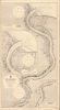

China The Whangpoo.
Navigating Shanghai's Waters and Turbulent Politics.
- Digital Map Information
- Suitable for large format printing
- Full resolution TIFF file
- ICC color profile embedded
- Delivered instantly via download link
Navigating Shanghai's Waters and Turbulent Politics.
This is a 1948 British Admiralty nautical chart or maritime map of the Huangpu (Whangpoo) River. It was produced during the Chinese Civil War (1927 - 1949), shortly after World War II (1939 - 1945), when Shanghai was in a state of turmoil, anxiety, and uncertainty.A Closer Look
This map depicts the region along the Huangpu River from just south of the urban core of Shanghai to the river's mouth, where it empties into the Yangzi (Yangtze) River. The downtown section of Shanghai along the 'Bund' and near the intersection of the Huangpu with the Suzhou Creek (Soochow Ho here) appears towards bottom, just to the right of the title. Buildings are illustrated along the entire length of the river, with different neighborhoods or sections of the city labeled in large block letters. Foreign consulates, including the German and Japanese, are labeled, along with train stations, fire stations, police stations, hospitals, churches, and other important public buildings near the Huangpu. The International Settlement (though not the French Concession) is maintained, anachronistically, as it had been eliminated during the war.Hydrographic information along the Huangpu is highly detailed, with myriad depth soundings included along the whole length of the river, allowing for ease of navigation. Navigational hazards, including wrecks, are noted, as are lights both within the river and along its banks. Information on tides, magnetic variations of the compass, and other details important to navigators is also included. Two inset maps appear, one depicting the Woosung Bar, the critically important site where the Huangpu meets the Yangzi River near where the latter empties into the East China Sea, and the other presenting a continuation of the Huangpu to the south of where the main chart ends.
Historical Context
When Shanghai was designated a treaty port in the 1842 Treaty of Nanjing, it was a fairly unassuming Chinese city and seemed an odd choice. But the British understood the potential of Shanghai due to its location on the Huangpu, itself near the mouth of the Yangzi River, which could act as a gateway deep into the interior of China. In the following decades, it dictated the flow of international trade, industrial raw materials, and food supplies. In the early 20th century, and especially under the Nanjing government of Chiang Kai-Shek (Jiang Jieshi), major efforts were undertaken to modernize Shanghai port facilities, especially in Wusong (Woosung), at the confluence of the Huangpu and Yangzi. The Huangpu also had important military significance as it was wide and deep enough to accommodate warships, a fact the Japanese exploited in the 1937 battle for the city when they sent devastating naval gunfire directly into the city's commercial and residential cores.This map was produced amid the hardships of the 1940s. During the Japanese occupation of the city (beginning in 1937 with the Chinese-administered parts of the city and moving to the foreign concessions in late 1941), control of the Huangpu allowed the occupying forces to strangle Western commercial interests and systematically extract resources to fuel their imperial war effort. In the late 1940s, the Chinese Civil War intensified, and hyperinflation crippled the urban economy, while many of Shanghai's wealthy residents fled the city in the face of the Communists and Chiang's heavy-handedness, with his son, Chiang Ching-kuo, employing methods he had learned in the Soviet Union to raid banks and 'war profiteer' businesses. Students and workers groups (infiltrated by the Communists) regularly clashed with the state, which responded with arbitrary violence, including torture and executions. When Communist troops marched into the city in May 1949 in an orderly fashion, residents were wary but hopeful that stability and security might be in the offing.
Publication History and Census
This chart was prepared by the British Admiralty, updating a chart originally prepared in 1927 using charts of the Chinese Maritime Customs Service and updated continuously thereafter. The British Library catalogs several editions of the chart, but not the present one, which does not appear in any institutional collections.Cartographer
The British Admiralty Office (1795 - Present) or the United Kingdom Hydrographic Office refers to the Branch of the English government that is responsible for the command of the British Navy. In 1795 King George III created the United Kingdom Hydrographic Office, known in short as the U.K.H.O., to provide top notch nautical charts to the vast Royal Navy. Prior the founding of the Admiralty the surveying and creation of nautical charts was primarily a commercial venture wherein the cartographer himself, more of than not, actually financed the printing of his own material. The great navigator Cook himself is known to have scrambled for funds to publish his own seminal charts - the most important and advanced of the period. The system of privately funded nautical mapping and publishing left vast portions of the world uncharted and many excellent charts unpublished. King George III, responding significant loss in trade revenue related to shipwrecks and delay due to poor charts, recognized the need for an institutionalized government sponsored cartographic agency - the Admiralty. The first head of the Admiralty, a position known as Hydrographer, was the important cartographer Alexander Dalrymple. Dalrymple started by organizing and cataloging obtainable charts before initiating the laborious process of updating them and filling in the blanks. The first official Admiralty Chart appeared in 1800 and detailed Quiberon Bay in Brittany. By 1808 the position of Hydrographer fell to Captain Thomas Hurd. Hurd advocated the sale of Admiralty charts to the general public and, by the time he retired in 1829, had issued and published some 736 charts. Stewardship of the organization then passed to Rear Admiral Sir Francis Beaufort. It was under Beaufort's administration that the Admiralty truly developed as a "chart making" as opposed to a "chart cataloging" institution. Beaufort held his post from 1829 to 1854. In his 25 years at the Admiralty Beaufort created nearly 1500 new charts and sponsored countless surveying and scientific expeditions - including the 1831 to 1836 voyage of the H.M.S. Beagle. By 1855 the Admiralty's chart catalog listed some 1,981 charts. Further Details...
Condition
Excellent. Lightly toned else fine.
References
OCLC 557924492 (earlier editions).